
Marong map unit Tfe2
Back to: A Land Capability Study of the Rural City of Marong
| Map Unit: | Tertiary fan, gentle slope, 2 | Map Unit Symbol: | Tfe2 |
| % of Study Area: | 0.04 |
General Description:
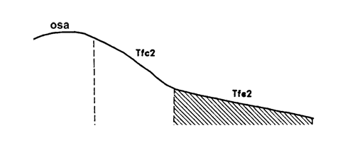
Colluvial fans developed on the southern slopes of the metamorphic aureole ridge overlying granodiorite. The soils are dominantly yellow duplex with fine sandy loam topsoils, hardsetting, bleached A2 horizons and extremely mottled clay subsoils. Many quartz and metamorphosed sedimentary fragments occur on the soil surface and throughout the profile. In the subsoil, the combination of clay and gravel has produced a compacted layer. Variations include fewer coarse fragments within the profile, particularly on lower slopes. Drainage lines within this unit often expose granodiorite boulders and so have been classified as granitic.
Site characteristics:
| Parent material age: | Tertiary | Depth seasonal watertable: | > 5 m |
| Lithology: | Sediments | Potential recharge to groundwater: | Moderate |
| Landform Pattern: | Undulating hills | Flooding risk: | Nil |
| Element: | Slopw | Drainage: | Well drained |
| Slope common: | 9% | Depth to hardrock: | > 1.5 m |
| Slope range: | 3-10% | ||
| Rock outcrop: | 0% |
Major vegetation: Grey Box, Yellow Box, Red Stringybark, Golden Wattle, Lightwood, Hedge Wattle, Spreading Wattle
Present land use: Native pasture
| Land degradation: | Water erosion | Wind erosion | Salting | Acidification | |
Sheet/rill | Gully | ||||
| Susceptibility | Very high | High | High | Moderate | High |
| Incidence | High | High | High | Moderate | Low |
Soil profile characteristics:
| Permeability (measured - average, range): | 510, 330 - 650 mm/day |
| Permeability (estimated): | - |
| Available water capacity: | 287 mm H2O |
| Linear shrinkage (B horizon): | 12.4% |
Soil profile description:
| A | 0 -14 cm | Brownish black (10YR3/2) fine sandy loam, weak structure, subangular blocky peds 5-10 mm, rough fabric, moderately weak consistence, many medium sized subangular metamorphic and quartz gravel fragments, moderate organic matter, pH 6.2. Clear transition to |
| A2 | 14-44 cm | Dull yellowish brown (10YR5/4) hardsetting fine sandy loam, bleached (10YR7/4) when dry, massive, earthy fabric, moderately weak consistence, a few medium sized subangular metamorphic and quartz gravel fragments, pH 5.4. Abrupt transition to |
| B | 44-112 + cm | Dull yellow orange (10YR6/7) medium clay, abundant medium sized distinct grey, orange, red and white mottles, moderate structure, subangular blocky peds 5-10 mm, rough fabric, moderately firm consistence, many coarse angular metamorphic and quartz fragments, pH 4.6. |
Soil classification:
| Factual Key (Northcote): | Dy 3.41 |
| Australian Soil Classification: | Bleached-Mottled, Yellow, Kurosol; deep, thick, loamy, moderately gravelly |
| Unified Soil Group: | CL |
Interpretation of soil analyses*
Horizon | pH | Gravel % | E.C. (salts) | Nutrient Status | P | K | Al | Organic Matter | Dispersibility |
| A | 6.2 | 44 | VL | L | S | S | S | M | H |
| A2 | 5.3 | 19 | VL | L | S | S | S | L | H |
| B | 4.6 | 34 | L | L | S | S | S | VL | L |
Land capability assessment
Land Use | Class | Major limiting feature(s)/ landuse |
| Agriculture (CTS values) | C3T3S5 | Very susceptible to sheet/rill erosion |
| Effluent disposal (septic tanks) | 2 | Nil |
| Farm dams (earthen) | 4 | Low suitablity of subsoil, lack of dispersion in subsoil, rapid permeability |
| Building foundations - slab | 3 | Gentle slope |
| Building foundations - stumps/footings | 2 | Nil |
| Secondary roads | 3 | Gentle slope, Universal Soil Group |
| Urban residential | 3 | Secondary roads, building foundations (slab) |
| Rural residential | 4 | Farm dams |
The high resolution PDF file provided on this page can be viewed using the free Adobe PDF reader, this software can be installed for free from the Adobe website (external link).
A Land Capability Study of the Rural City of Marong - map unit Tfe2 - (PDF - 39.1 KB)
© State of Victoria (Agriculture Victoria) 1996 - .

This work, Victorian Resources Online, is licensed under a Creative Commons Attribution 4.0 licence. You are free to re-use the work under that licence, on the condition that you credit the State of Victoria (Agriculture Victoria) as author, indicate if changes were made and comply with the other licence terms.
The licence does not apply to ‘branding’ or some ‘images or photographs’ that may be owned by third parties. We ask you to seek prior approval to use images using the VRO feedback form. Access to higher quality images can also be provided on request.
This page was last updated on .