
A Land Capability Study of the Shire of Newham and Woodend
In 1992, a land capability study was undertaken by the former Department of Conservation and Environment in the Shire of Newham & Woodend. Different land areas were recognised by aerial photo interpretation, field inspection and sampling, enabling a base map at a scale of 1:25,000 to be produced.
Thirty one map units were identified and the land characteristics considered relevant for land capability assessment described in terms of geology, landform, climate, soils and vegetation. The capability of the map units for specific land uses was assessed in terms of the kind and degree of limitations.
The Information was aimed to be used by planners to assist in the preparation of planning strategies and encourage the most appropriate land uses and management practices to minimise land degradation in the short term and long term, but sustain productivity.
To view the information PDF requires the use of a PDF reader. This can be installed for free from the Adobe website (external link).
| Dga (PDF 135KB) | Dgb (PDF 135KB) | Dgc (PDF 139KB) | Dge (PDF 138KB) | Dgg (PDF 137KB) | Dgp (PDF 139KB) | Dra (PDF 123KB) | Drb (PDF 133KB) | Drc (PDF 143KB) | Dre (PDF 138KB) |
| Osb (PDF 140KB) | Osc (PDF 139KB) | Osd (PDF 138KB) | Ose (PDF 139KB) | Osf (PDF 158KB) | Osg (PDF 138KB) | Qa1 (PDF 135KB) | Qa2 (PDF 149KB) | Tba (PDF 143KB) | Tbc (PDF 242KB) |
| Tbe (PDF 157KB) | Tbf (PDF 132KB) | Tbg (PDF 142KB) | Tva (PDF 128KB) | Tvb (PDF 150KB) | Tvc (PDF 156KB) | Tve (PDF 137KB) | Tvf (PDF 139KB) | Tvg (PDF 158KB) | Tvh (PDF 132KB) |
| Tvo (PDF 154KB) |
 | Front Page and Table of Contents (PDF 104KB) | 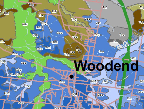 Land Capability Study of Newham Woodend - Map Units | |
| Summary (PDF 94KB) | |||
| Acknowledgements (PDF 647KB) | |||
| 1 | Introduction (PDF 73KB) | ||
| 2 | Land Capability Assessment (PDF 240KB) | ||
| 3 | Land Management Guidelines (PDF 82KB) | ||
| 4 | Detailed Map Descriptions and Capability Ratings (PDF 571KB) (See list above for individual map units) | ||
| 5 | Description of the Environment (PDF 757KB) | ||
| References (PDF 133KB) | |||
| Glossary (PDF 133KB) | |||
| Appendices Appendix 1 - Notes to accompany Land Capability Rating Tables (PDF 492KB) Appendix 2 - Physical and Chemical Analytical Results (PDF 2.2MB) Appendix 3 - Saturated Hydraulic Conductivity - Double Ring Infiltration Method (PDF 176KB) |
© State of Victoria (Agriculture Victoria) 1996 - .

This work, Victorian Resources Online, is licensed under a Creative Commons Attribution 4.0 licence. You are free to re-use the work under that licence, on the condition that you credit the State of Victoria (Agriculture Victoria) as author, indicate if changes were made and comply with the other licence terms.
The licence does not apply to ‘branding’ or some ‘images or photographs’ that may be owned by third parties. We ask you to seek prior approval to use images using the VRO feedback form. Access to higher quality images can also be provided on request.
This page was last updated on .