
Calcarosols
Calcarosols lack strong texture contrast between surface (A) and subsoil (B) horizons. These soils are also calcareous throughout and often have accumulations of calcium carbonate (lime) in the soil profile. These soils form on calcareous, aeolian sediments of variable texture.
In the Mallee, Calcarosols generally have a small, gradual increase in clay content with depth. Lime is abundant in the subsoils, either in soft form, in nodules or as blocks, and it may extend to the surface of medium to heavy textured soils. The pH tends to be highly alkaline. However, the upper horizons in sands may only be weakly alkaline. Sodicity and salinity levels are usually high in the heavier subsoils.
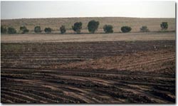 Dune and swale landscape near Walpeup. |
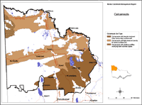
| Calcarosols in the Mallee Region. This map of Calcarosols in the Mallee region has been developed by Jim Rowan and is based on the Land Systems of Victoria (1:250 000). It shows areas where Calcarosols are most likely to occur within the region and should only be used as a general indication of their distribution. Please note that other soil types may also occur within these mapped areas. Calcarosols may occur in areas not mapped here, however, these are most likely to be minor occurrences. |
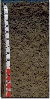
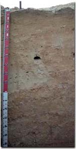 A sandy Calcarosol associated with a dune near Waleup. |
The Calcarosols in the Mallee region vary quite considerably in terms of soil texture - ranging from those dominated by sands to those that are clayey throughout. Soil texture has a big influence on the agronomic performance of the land. Sands are easily worked, but they have low fertility reserves and are very prone to wind erosion. Heavier textured soils are more fertile and less erodible, but more prone to salting and hardsetting when over-cultivated. | 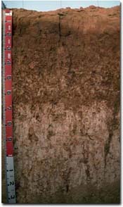 A Calcarosol associated with swales near Walpeup. These soils have a sandy loam surface. |
 A Calcarosol near Birchip. This soil has a light clay surface that grades to medium to heavy clay. |
Three kinds of Calcarosols are shown on the map - light textured, heavy textured and stony.
|
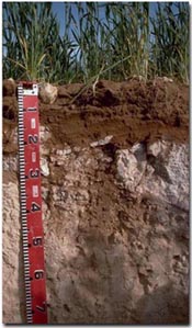 A shallow Calcarosol overlying hard calcrete material near Walpeup. |
|
© State of Victoria (Agriculture Victoria) 1996 - 2025.

This work, Victorian Resources Online, is licensed under a Creative Commons Attribution 4.0 licence. You are free to re-use the work under that licence, on the condition that you credit the State of Victoria (Agriculture Victoria) as author, indicate if changes were made and comply with the other licence terms.
The licence does not apply to ‘branding’ or some ‘images or photographs’ that may be owned by third parties. We ask you to seek prior approval to use images using the VRO feedback form. Access to higher quality images can also be provided on request.
This page was last updated on 23/03/2020.