
Site GL173
Location: Dobie.
Australian Soil Classification: Mottled, Epipedal, Brown VERTOSOL (confidence level 1)
Land Mapping Unit: Hillside Basalts.
General Land Unit Description: This land unit represents the gently undulating to undulating basalt plains around Ararat. The plains are often dissected with very slight rises. The soils on the plains are commonly Brown Vertosols (represented by this site). There are commonly large cracks on the surface when the soil is dry. The soil indicates that there is some gilgai micro-relief although it is not that evident at the surface. Rock outcrop can occur, particularly on the crests of the small rises. Ferromanganiferous nodules may also occur above the clayey subsoil, often occurring as a thin band.
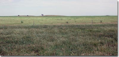 Site GL173 Landscape |
| Site Description: Slope: 2% Geology: Quaternary basalt. Landform pattern: Level to gently undulating plain. Position in landscape: Plain. Internal drainage: Poorly drained. |
Soil Profile Morphology:
Surface Soil
| A1 | 0-15 cm | Dark brown (10YR3/3) medium clay; strong very fine polyhedral structure; firm consistence when dry; pH 5.6; clear but wavy change to: | 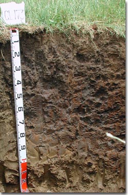 Site GL173 Profile |
| Subsoil | |||
| B21 | 15-40 cm | Brown (10YR5/3) with many distinct reddish yellow (7.5YR6/8) mottles; heavy clay; strong coarse prismatic, parting to strong coarse angular blocky structure, very firm consistence (dry); pH 6.1; clear change to: | |
| B22 | 40-90 cm | Dark greyish brown (10YR4/2) with many distinct strong brown (7.5YR4/6) mottles; heavy clay; strong coarse prismatic, parting to strong coarse angular blocky structure; few distinct slickensides; pH 6.4; diffuse change to: | |
| B3 | 90-140 cm | Light olive brown (2.5Y5/4) with many faint light brownish grey (2.5YR6/2) mottles; heavy clay; strong lenticular structure; few distinct slickensides; pH 6.5. | |
Key Profile Features:
- Clay texture throughout soil profile.
- Significant cracking when dry.
Soil Profile Characteristics:
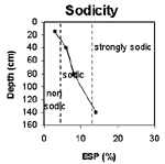
pH | Salinity Rating | |||
Surface (A1 horizon) | Moderately Acid | Low | Non-Sodic | None 1 |
Subsoil (15-40 cm) | Slightly Acid | Low | Marginally Sodic | None 1 |
Deeper Subsoil (90-140 cm) | Slightly Acid | Low | Sodic | None 2 |
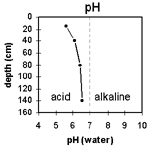 | 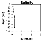 |  |  |
Horizon | Horizon Depth (cm) | pH (water) | pH (CaCl2) | EC 1:5 | Exchangeable Cations | |||
Ca | Mg | K | Na | |||||
meq/100g | ||||||||
A1 | 0-15 | 5.6 | 4.6 | 0.09 | 6.4 | 7.6 | 0.80 | 0.86 |
B21 | 15-40 | 6.1 | 5.1 | 0.14 | 6.4 | 10 | 0.60 | 1.9 |
B22 | 40-80 | 6.4 | 5.3 | 0.26 | 5.5 | 9.4 | <0.1 | 2.6 |
B3 | 80-140 | 6.5 | 6.3 | 0.27 | 4.7 | 11 | 0.1 | 4.3 |
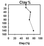
Horizon | Horizon Depth (cm) | Exchangeable Aluminium mg/kg | Exchangeable Acidity meq/100g | Field Capacity pF2.5 | Wilting Point pF4.2 | Coarse Sand (0.2- 2.0 mm) | Fine Sand (0.02- 0.2 mm) | Silt (0.002- 0.02 mm) | Clay (<0.002 mm) |
A1 | 0-15 | 28 | 15 | 34 | 45 | 6 | 19 | 14 | 55 |
B21 | 15-40 | 13 | 14 | 22 | 28 | 5 | 14 | 10 | 69 |
B22 | 40-80 | <10 | 13 | 43 | 51 | 3 | 13 | 14 | 67 |
B3 | 80-140 | <10 | 11 | 27 | 31 | 1 | 10 | 8 | 79 |
© State of Victoria (Agriculture Victoria) 1996 - .

This work, Victorian Resources Online, is licensed under a Creative Commons Attribution 4.0 licence. You are free to re-use the work under that licence, on the condition that you credit the State of Victoria (Agriculture Victoria) as author, indicate if changes were made and comply with the other licence terms.
The licence does not apply to ‘branding’ or some ‘images or photographs’ that may be owned by third parties. We ask you to seek prior approval to use images using the VRO feedback form. Access to higher quality images can also be provided on request.
This page was last updated on .