
PVI 5
| Site: PVI 5 | Land Unit: Buckley Swamp Peats |
| Aust. Soil Class.: Terric, Basic, Sapric ORGANOSOL (confidence level 1) | |
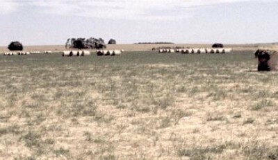 | General Land Unit Description: Buckley Swamp consists of a valley infilled by an earlier lava flow, with the subsequent blockage of the drainage line resulting in peat accumulation. The area has been drained and burnt at various times in the past, resulting in some decomposition and loss of peat. The dominant soils of the plain are Organosols with massive or well-structured surfaces. The soils of the backplain are commonly Hydrosols with well structured surfaces and peaty horizons. There are also minor occurrences of Vertosols. |
Site Description:
| Geology: Quaternary basalt overlain by alluvials | Landform pattern: Flood plain |
| Position in landscape: Drainage depression | Internal drainage: Imperfectly drained |
| A1 | 0-20 cm | Black (10YR2/1), loam, weak coarse blocky structure, very weak consistence (dry), pH 5.8. Clear change to: | 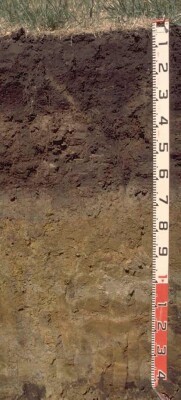 |
| Subsoil | |||
| B21 | 20-30 cm | Black (10YR2/1), fine sandy clay loam (organic), strong medium polyhedral, parting to strong fine to very fine polyhedral structure, very firm consistence (dry), pH 5.8. Sharp change to: | |
| P21 | 30-45 cm | Very pale brown (10YR7/3), laminated sapric peat. Sharp change to: | |
| P22 | 45-60 cm | Very dark grey (10YR3/1), clayey peat. Sharp change to: | |
| D1 | 60-70 cm | Grey (5Y5/1), medium clay, pH 7.0. Clear change to: | |
| D2 | 70-80 cm | Grey (5Y6/1) with yellow (5Y7/6) mottles, sandy clay. Sharp change to: | |
| D3 | 80+ cm | Pale olive (5Y6/4), sandy clay loam, pH 8.0, rusty root channel mottling. |
Key Profile Features
- Very high organic matter levels in upper soil profile
pH | Salinity Rating | Sodicity | Dispersion | |
Surface soil (A1 horizon) | Moderately Acid | Low | Non-Sodic | None |
Upper subsoil (20-30 cm) | Moderately Acid | Low | Non-Sodic | None |
Deeper subsoil (at 60-70 cm) | Moderately Alkaline | HIgh | Non-Sodic | - |
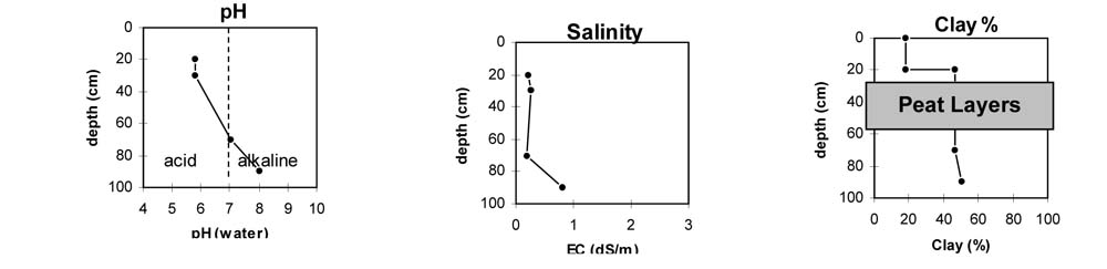
Horizon | Horizon Depth | pH (water) | pH CaCl2 | EC dS/m | NaCl % | Exchangeable Cations | Ex Al mg/kg | Ex Ac meq/100g | Field pF2.5 | Wilting Point pF4.2 | Coarse Sand (0.02-0.2mm) | Fine Sand (0.02-0.2mm) | Silt (0.02-0.02mm) | Clay (<0.002mm) | Total Carbon (% w/w) | |||
Ca | Mg | K | Na | |||||||||||||||
meq/100g | ||||||||||||||||||
A1 | 0-20 | 5.8 | 5.6 | 0.21 | 32 | 16 | 0.27 | 1.3 | 23 | 30 | 72.6 | 52.6 | 39.3 | 8.7 | 12 | 18 | 23 | |
B21 | 20-30 | 5.8 | 5.7 | 0.25 | 39 | 22 | 0.72 | 1.7 | 28 | 31 | 76.7 | 63.7 | 7.4 | 36.8 | 6 | 46.5 | 28 | |
P21 | 30-45 | Peat Layers | ||||||||||||||||
P22 | 45-60 | |||||||||||||||||
D1 | 60-70 | 7.0 | 6.0 | 0.20 | 9.8 | 12 | 0.43 | 1.2 | 7.4 | 36.8 | 6 | 46.5 | ||||||
D3 | 80+ | 8.0 | 7.6 | 0.81 | .1 | 21 | 17.5 | 50 | ||||||||||
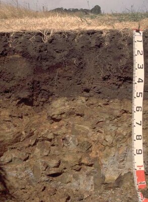 | Site PVI 5a - Paralithic, Basic, Sapric ORGANOSOL Note: In some areas of the paddock the weathered basalt occurs within 50 cm of the soil surface. |
© State of Victoria (Agriculture Victoria) 1996 - .

This work, Victorian Resources Online, is licensed under a Creative Commons Attribution 4.0 licence. You are free to re-use the work under that licence, on the condition that you credit the State of Victoria (Agriculture Victoria) as author, indicate if changes were made and comply with the other licence terms.
The licence does not apply to ‘branding’ or some ‘images or photographs’ that may be owned by third parties. We ask you to seek prior approval to use images using the VRO feedback form. Access to higher quality images can also be provided on request.
This page was last updated on .