
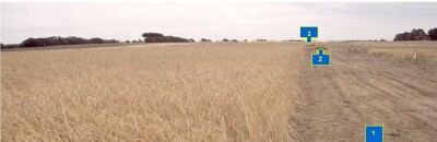
PVI 2
| Site: PVI 2 | Land Unit: Monivae Basalt |
| Aust. Soil Class.: Vertic (& Ferric), Eutrophic, Yellow SODOSOL (thick, clay loamy surface) (confidence level 1) | |
 | General Land Unit Description: The level to gently undulating basalt plains between Branxholm and Glenthompson consist of an association of Vertic or Ferric Brown Chromosols and Ferric Brown Sodosols. The Chromosols typically occur on the upper slopes and crests of very slight rises that may have scattered surface boulders, and Sodosols on the lower slopes and depressions. Sodosols or Vertosols, occasionally with a sporadic bleached subsurface horizon, are usually found in open depressions or drainage lines. |
Site Description:
| Geology: Quaternary basalt | Landform pattern: Plain |
| Position in landscape: Midslope of low rise (lower lying) | Internal drainage: Moderately well drained |
| A1 | 0-20 cm | Brown (10YR4/3), very fine sandy clay loam, weak coarse blocky (occasionally parting to strong coarse to medium polyhedral structure), very weak consistence (dry), pH 5.5. Clear change to: | 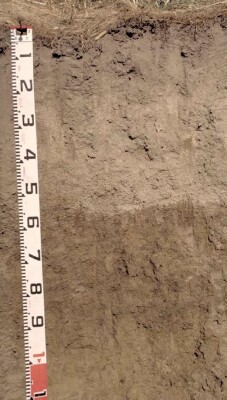 |
| A21 | 20-40 cm | Yellowish brown (10YR5/4) with strong brown (7.5YR5/8) mottles, conspicuously bleached (10YR7/2 dry), fine sandy clay loam, massive, strong consistence (dry), pH 6.0. Clear change to: | |
| A22 | 40-55 cm | Yellowish brown (10YR5/4), conspicuously bleached (10YR7/2 dry), fine sandy clay loam, massive, firm consistence (dry), very many (80%) ferruginous nodules, (2-10 mm size). Abrupt and wavy change to: | |
| Subsoil | |||
| B21 | 55-65 cm | Brownish yellow (10YR6/6) with brown (10YR4/3) and dark red (2.5YR4/8) mottles, medium clay, moderate coarse blocky, parting to strong medium blocky structure, some dark staining on ped faces, very firm consistence (moist), pH 7.1. Clear change to: | |
| Note: In some areas the upper subsoil (B21 horizon) can be darker (10YR4/4) with brownish yellow (10YR6/6) mottles. In these areas, there is usually less ferruginous gravel in the A2 horizon. These variations are associated with the original gilgai microrelief. | |||
| B22 | 65-90 cm | Brownish yellow (10YR6/8) with very dark greyish brown (10YR3/2) mottles, medium clay, moderate to strong coarse prismatic, parting to moderate to strong medium prismatic and moderate coarse to medium blocky structure, some manganese stains, very firm consistence (moist), pH 7.1. Gradual change to: | |
| B23 | 90-120+ cm | Brownish yellow (10YR6/6) with many (40%) light grey (2.5Y7/2) mottles, medium heavy clay, strong lenticular structure, firm consistence (moist), pH 7.2. | |
Key Profile Features
- Variation in soil profile features associated with gilgai microrelief
- Strong texture contrast between surface (A) horizons and subsoil (B) horizon
- Thick conspicuously bleached subsurface (A2) horizon
- Large amount of ferruginous nodules in subsurface (A2) horizon
- Vertic (cracking) properties (i.e. lenticular peds) in deep subsoil
pH | Salinity Rating | Sodicity | Dispersion | |
Surface soil (A1 horizon) | Strongly Acid | Low | Non-Sodic | None |
Upper subsoil (55-65 cm) | Near Neutral | Low | Marginally Sodic | None |
Deeper subsoil (at 90-120 cm) | Near Neutral | Low | Sodic | None |
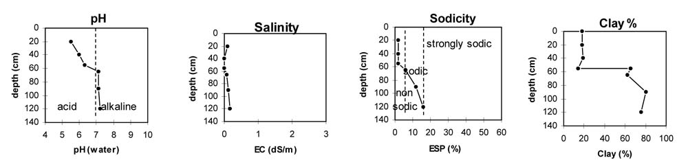
Horizon | Horizon Depth | pH (water) | pH CaCl2 | EC dS/m | NaCl % | Exchangeable Cations | Ex Al mg/kg | Ex Ac meq/100g | Field pF2.5 | Wilting Point pF4.2 | Coarse Sand (0.02-0.2mm) | Fine Sand (0.02-0.2mm) | Silt (0.02-0.02mm) | Clay (<0.002mm) | |||
Ca | Mg | K | Na | ||||||||||||||
meq/100g | |||||||||||||||||
A1 | 0-20 | 5.5 | 4.2 | 0.09 | 3.5 | 1.7 | 0.28 | 0.28 | 37.1 | 10.9 | 3.5 | 40.1 | 29.0 | 18.5 | |||
A21 | 20-40 | 6.0 | 4.8 | <0.05 | 2.2 | 1.3 | 0.10 | 0.17 | 26.2 | 7.6 | 10.8 | 40.4 | 28.5 | 19.0 | |||
A22 | 40-55 | 6.3 | 5.2 | <0.05 | 2.4 | 1.5 | 0.13 | 0.18 | 16.5 | 9.0 | 54.5 | 16.0 | 13.0 | 14.5 | |||
B21 | 55-65 | 7.1 | 5.8 | 0.08 | 3.9 | 6.5 | 0.33 | 1.2 | 8.7 | 39.5 | 23.5 | 10.2 | 17.1 | 10.0 | 62.0 | ||
B22 | 65-90 | 7.1 | 5.7 | 0.11 | 4.9 | 8.9 | 0.33 | 1.9 | 49.9 | 30.2 | 1.2 | 10.2 | 7.0 | 80.5 | |||
B23 | 90-120 | 7.2 | 5.9 | 0.17 | 4.8 | 9.8 | 0.28 | 2.9 | 51.7 | 30.0 | 2.5 | 12.5 | 9.0 | 75.5 | |||
© State of Victoria (Agriculture Victoria) 1996 - .

This work, Victorian Resources Online, is licensed under a Creative Commons Attribution 4.0 licence. You are free to re-use the work under that licence, on the condition that you credit the State of Victoria (Agriculture Victoria) as author, indicate if changes were made and comply with the other licence terms.
The licence does not apply to ‘branding’ or some ‘images or photographs’ that may be owned by third parties. We ask you to seek prior approval to use images using the VRO feedback form. Access to higher quality images can also be provided on request.
This page was last updated on .