
MM252
| Site: MM252 | Land Unit: Merri River Basalts |
| Aust. Soil Class.: Vertic, Eutrophic, Black CHROMOSOL (confidence level 4) | |
| General Land Unit Description: This complex unit comprises the rolling low hills and valley sides adjacent to the Merri River, north of Warrnambool, together with its alluvial plains and terraces. This unit is a complex mix of geologies. The major geology is basalt, although Tertiary marl can also occur, along with the alluvial plains and terraces. The hillslopes facing the river are neutral, well structure Black Dermosols, while their crests are neutral Black Chromosols, which are relatively shallow. The soils of the hillslopes away from the creek merge with the soils of the basalt plan and are Mottled Brown Chromosols. The alluvial plains and lower level terraces are alkaline, black self-mulching cracking clays (Vertosols), while in situations where there are terraces at more than one level, the soils of the higher terraces are neutral, well-structured black gradational soils (Black Dermosols). |
Site Description:
| Geology: Quaternary basalt | Landform pattern: Rolling low hills |
| Position in landscape: Flat | Internal drainage: Imperfectly drained |
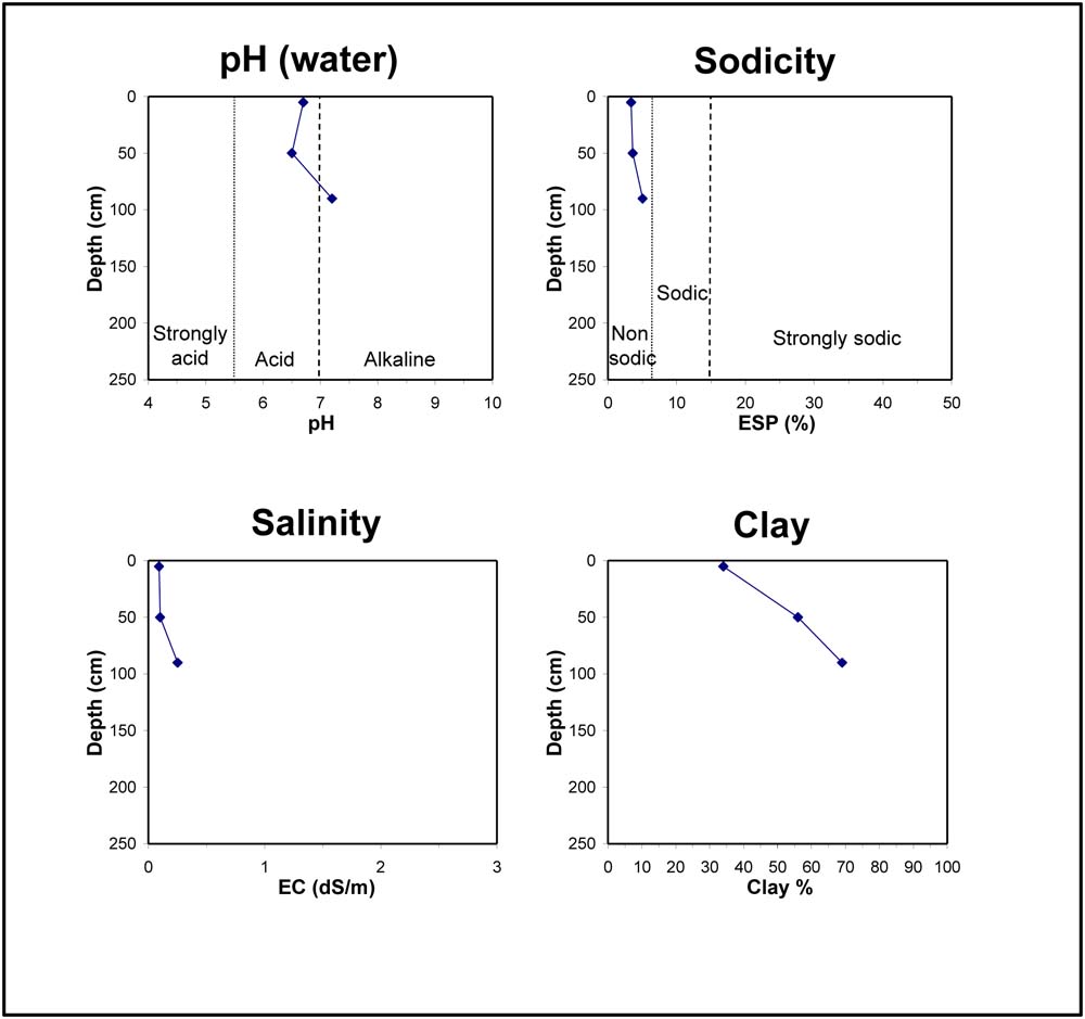
| A1 | 0-10 cm | Very dark brown (10YR2/2) clay loam, strong blocky structure (20-50 mm), very firm consistence when moderately moist, pH 6.7, cracking surface condition. Clear transition to: |
| Subsoil | ||
| B21 | 10-90 cm | Very dark brown (10YR2/2) heavy clay, strong blocky structure (5-10 mm), smooth fabric, firm consistence when moderately moist, pH 6.5. Gradual transition to: |
| B22 | 90+ cm | Very dark greyish brown (10YR3/2) medium clay, massive structure, firm consistence when moderately moist, pH 7.2. |
Key profile features:
- Strong texture contrast between topsoil and subsoil
- Cracking surface
© State of Victoria (Agriculture Victoria) 1996 - .

This work, Victorian Resources Online, is licensed under a Creative Commons Attribution 4.0 licence. You are free to re-use the work under that licence, on the condition that you credit the State of Victoria (Agriculture Victoria) as author, indicate if changes were made and comply with the other licence terms.
The licence does not apply to ‘branding’ or some ‘images or photographs’ that may be owned by third parties. We ask you to seek prior approval to use images using the VRO feedback form. Access to higher quality images can also be provided on request.
This page was last updated on .