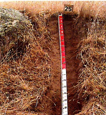
LSWW25
| Site: LSWW25 | Land Unit: Nareen Granite |
| Aust. Soil Class.: Bleached, ?, Red CHROMOSOL (confidence level 3) | |
| General Land Unit Description: Granite material is mainly found dissecting the Glenelg River and on the low hills and rises around Nareen. The dominant soil type is a Mottled Brown Chromosol (GL161) although this site represents variant that occurs on the better drained slopes. Due to the steep slopes, the lower slopes tend to have colluvial material deposited on top. This is the minor soil type representing the Nareen Granites land unit, occurring mainly on the dissected slopes to the Glenelg River. |
Site Description:
| Slope: 10% | Geology: Ordovician granite / granodiorite |
| Landform pattern: Low hills and rises | Position in landscape: Mid slope |
| Internal drainage: Moderately well drained |
| A1 | 0-10 cm | Brown (7.5YR4/2) sandy loam, moderate subangular blocky structure, (peds 5-10 mm), weak consistence when dry, many (30%) granitic fragments, pH 5.7. Clear to abrupt transition to: |  |
| A2 | 10-140 cm | Brown (7.5YR4/2) sandy clay loam, conspicuously bleached, weak to massive structure, weak consistence when dry, many (40-50%) granitic fragments, pH 5.7. Transition to: | |
| Subsoil | |||
| B2 | 140-150 cm | Dusky red (2.5YR4/3) medium heavy clay, polyhedral structure, smooth faced peds, granitic fragments are common (15%), pH 5.6. Transition to: | |
| C | 150+ cm | Weathered granitic bedrock |
Key Profile Features
- Strong texture contrast between topsoil and subsoil
- Bleached A2 horizon
- Acidic topsoil
- Acidic subsoil
- Small amount of clay formation from the granite bedrock
- Strong structure of the subsoil


