
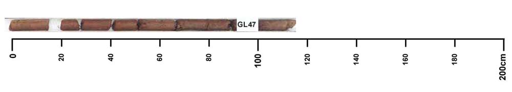
GL47
| Site: GL47 | Land Unit: Follet Dunes and Plains |
| Aust. Soil Class.: Haplic, Eutrophic, Red CHROMOSOL (high free iron) (confidence level 1) | |
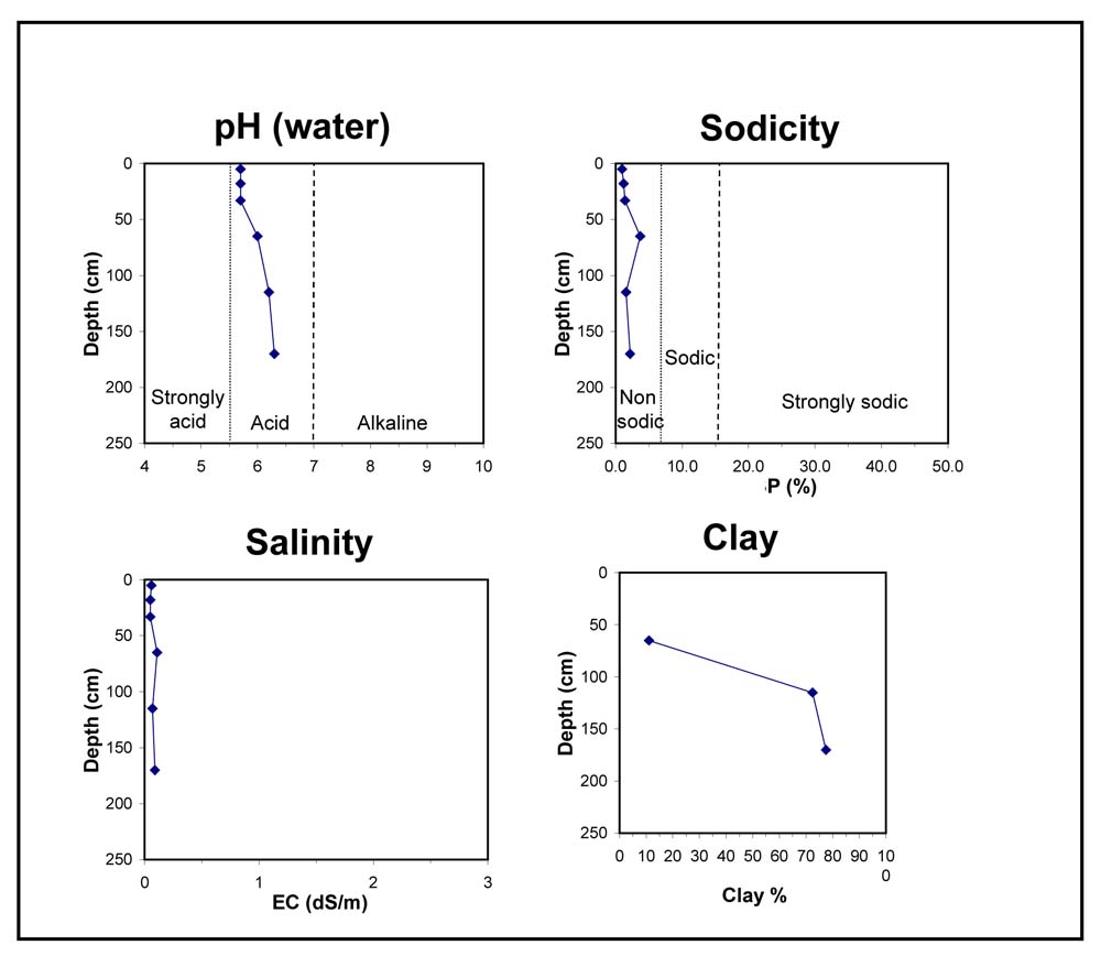
 | General Land Unit Description: The majority of this land unit falls south of the Kanawinka fault. This land unit comprises areas with deep sand deposits. The residual landscape is thought to be influenced by the retreat of the Murray Sea which left stranded beach ridges oriented south west–north east. These were subsequently covered by superficial sand sheets in later depositional phases, which formed the landscape we see today. The major landforms in this land unit are dunes and swales. Podosols and Kurosols or Chromosols are the major soil types found on the dunes and rises. The Kurosols or Chromosols tend to have a deep sandy topsoil over the clay. The common soil types on the swales are black cracking clay (Vertosols) or Grey Sodosols. Some Ferric Kurosols or Chromosols can also occur on the swales or lower slopes of the dunes. This site is characterised by a strong texture contrast (Chromosol) but it also has a high level of free iron (7.9 %) in the subsoil, which is it’s most distinguishing feature. This soil typically occurs on the lower dunes and slopes of some of the dunes. This soil tends to have a heavier textured subsoil compared to the Tenosols and Rudosol. This soil type has been mapped as aeolian geology, possibly due to the deep sandy topsoil. It is not clear what the origin of the subsoil is, although it is likely that it may be of basalt origin, since high free iron is often associated with this geology. This soil type is similar to site GL41, GL42, GL43 and GL80 and they tend to have a higher capability of supporting a range of land uses (e.g. Viticulture), due to their favourable physical and chemical properties. |
Site Description:
| Slope: 3% | Geology: Quaternary aeolian |
| Landform pattern: Dune | Position in landscape: Lower slope |
| Internal drainage: Moderately well drained |
| 1A11 | 0-10 cm | Very dark grey (10YR3/1) sand, massive structure, weak consistence when dry, pH 5.7; transition to: |
| 1A12 | 10-25 cm | Dark greyish brown (10YR4/2) sand, massive structure, weak consistence when dry, pH 5.7; transition to: |
| 1A13 | 25-40 cm | Brown (7.5YR4/4) sand, massive structure, weak consistence when dry, pH 5.7; transition to: |
| 1A14 | 40-95 cm | Strong brown (7.5YR5/6) sand, very faint red mottles are common, massive structure, strong consistence when dry, pH 6.0; transition to: |
| Subsoil | ||
| 2B21 | 95-200 cm | Dark red (2.5YR3/6) light clay, moderate to strong structure, sand veins present, pH 6.2. |
Key profile features:
- Deep sandy topsoil
- Strong textural contrast between topsoil and subsoil
- High free iron in the subsoil
© State of Victoria (Agriculture Victoria) 1996 - .

This work, Victorian Resources Online, is licensed under a Creative Commons Attribution 4.0 licence. You are free to re-use the work under that licence, on the condition that you credit the State of Victoria (Agriculture Victoria) as author, indicate if changes were made and comply with the other licence terms.
The licence does not apply to ‘branding’ or some ‘images or photographs’ that may be owned by third parties. We ask you to seek prior approval to use images using the VRO feedback form. Access to higher quality images can also be provided on request.
This page was last updated on .