
DOW98 (Plot 4)
| Site: DOW98 (Plot 4) | Land Unit: Follet Dunes and Plains |
 |
General Land Unit Description:
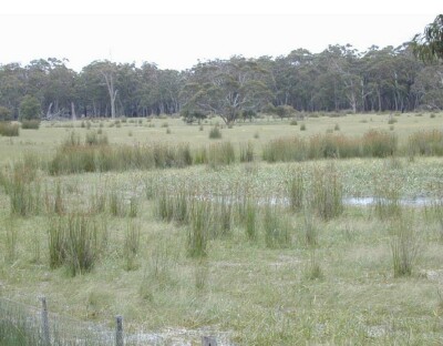
The major landforms in this land unit are dunes and swales. Podosols and Kurosols or Chromosols are the major soil types found on the dunes and rises. Podosols are soils with a ‘coffee rock’ layer (refer to photograph below). The Kurosols or Chromosols tend to have a deep sandy topsoil over the clay. The common soil types on the swales are black cracking clay (Vertosols) or Grey Sodosols. Some Ferric Kurosols or Chromosols can also occur on the swales or lower slopes of the dunes. 2.5 year old Eucalyptus globulus plantation on ex-agricultural land |
Site Description:
| Geology: Quaternary aeolian | Landform pattern: Gently Undulating Plain |
| Internal drainage: Imperfectly drained |
Soil Profile Morphology
| A1 | 0-20 cm | Dark greyish brown (10YR4/2) sandy loam; weak granular structure (5-10 mm); very weak consistence when dry; many medium roots; clear and smooth transition to: | 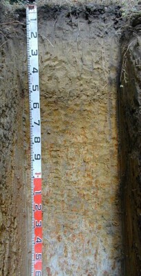 |
| A2 | 20-40 cm | Light yellowish brown (10YR6/4) sandy loam (plus); massive structure; very weak consistence when dry; many medium roots; clear and smooth transition to: | |
| A3 | 40-50 cm | Yellowish brown (10YR5/4) sandy clay; massive structure; very weak consistence when moderately moist; few medium ferruginous nodules; many very fine macropores; aereal porosity 0.2%; many medium roots; clear and smooth transition to: | |
| Subsoil | |||
| Bs | 50-55 cm | Yellowish brown (10YR5/4) sandy clay; unable to assess structure and macroporosity due to the presence of very many segregations; weak consistence when moderately moist; very many medium ferruginous nodules; few very fine roots; abrupt and smooth transition to: | |
| B21 | 55-85 cm | Brown (10YR5/6) with few medium distinct red (2.5YR4/8) mottles, light clay; moderate polyhedral structure (20-50 mm) parting to moderate polyhedral structure (10-20 mm); weak consistence when moderately moist; common very fine macropores; areal porosity 0.1%; few very fine roots; diffuse and smooth transition to: | |
| B22 | 85-130 cm | Yellowish brown (10YR5/6) with many medium distinct red (2.5YR4/8) and light grey (10YR7/2) mottles, light clay; moderate polyhedral structure (20-50 mm) parting to moderate polyhedral structure (10-20 mm); weak consistence when moist; common very fine macropores; areal porosity 0.08%; few very fine roots; gradual and smooth transition to: | |
| B3 | 130-160 cm | Light grey (10YR7/2) with many coarse prominent red (2.5YR4/8) and brownish yellow (10YR6/8) mottles, medium heavy clay (with sand); weak polyhedral structure (20-50 mm); firm consistence when moist; few very fine macropores; areal porosity 0.03%; few very fine roots. | |
| 160-390 cm | Medium to heavy grey clays (coarsely structured with slickensides) with pockets of red/brown sandy clay, live roots to 300 cm, remnant roots to 390 cm in cracks and in planes along ped faces. | ||
Notes: Sampled by: Ian Sargeant and Paul Feikema (11 December 2000)
© State of Victoria (Agriculture Victoria) 1996 - .

This work, Victorian Resources Online, is licensed under a Creative Commons Attribution 4.0 licence. You are free to re-use the work under that licence, on the condition that you credit the State of Victoria (Agriculture Victoria) as author, indicate if changes were made and comply with the other licence terms.
The licence does not apply to ‘branding’ or some ‘images or photographs’ that may be owned by third parties. We ask you to seek prior approval to use images using the VRO feedback form. Access to higher quality images can also be provided on request.
This page was last updated on .