
Site GL175
Location: Langi Logan South.
Land Mapping Unit: Ararat Schists.
Australian Soil Classification: Bleached-Mottled, Eutrophic, Brown CHROMOSOL (confidence level 1).
General Land Unit Description:
This land unit consists of hills with metamorphic schists. The soils tend to be quite shallow, often around 60 cm in depth. There can be a bleached subsurface (A2) horizon. In some cases, particularly on the steeper slopes and crests, there can be many quartz coarse fragments, usually above the clay subsoil. The most common landform is undulating rises, which this site represents. The steeper the land the shallower the soil, and banded rock outcrops become more apparent. The capability of the low hills and hills land units are limited due to the slope, rock outcrops and shallow soils, as well as the susceptibility to water erosion. The gently undulating plains generally form the lower slopes of the rises. These have better capability for land use options and generally have deeper soils and a more favourable landscape.
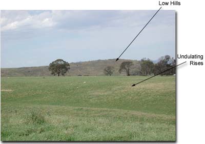 Site GL175 Landscape |
Site Description:
Slope: 16%
Geology: Cambrian schists.
Landform Pattern: Undulating rises.
Position in Landscape: Lower slope.
Internal Drainage: Moderately well drained.
Soil Profile Morphology:
Surface Soil
| A1 | 0-30 cm | Dark brown (10YR3/3); fine sandy loam; weak coarse angular blocky structure; very firm consistence (dry); pH 5.9; abrupt change to: | 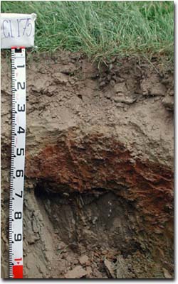 Site GL175 Profile |
| A2 | 30-45 cm | Yellowish brown (10YR5/6); fine sandy loam; conspicuously bleached (10YR8/2 dry); massive structure, firm to very firm consistence (dry); many large angular quartz coarse fragments (10-50 mm); pH 6.5; clear and wavy change to: | |
| Subsoil | |||
| B21 | 45-60 cm | Yellowish brown (10YR5/6); medium heavy clay; many distinct red (2.5YR4/8) mottles; strong coarse prismatic, parting to strong coarse angular blocky structure; very firm consistence (dry); pH 7.0; change to: | |
| C | 60-120+ cm | Weathered rock. | |
Key Profile Features:
- Strong texture contrast between surface (A) horizons and subsoil (B) horizons.
- Shallow soil profile.
- Conspicuously bleached subsurface (A2) horizon.
- Many coarse fragments in subsurface (A2) horizon.
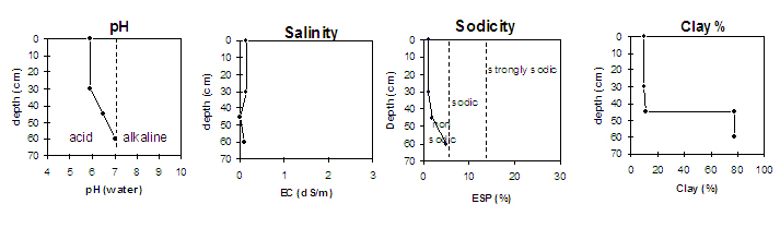
Soil Profile Characteristics:
pH | Salinity Rating | |||
Surface (A1 horizon) | Moderately Acid | Low | Non-Sodic | None |
Subsoil (45-60 cm) | Neutral | Low | Non-Sodic | None |
 |
Horizon | Horizon Depth (cm) | pH (water) | pH (CaCl2) | EC 1:5 | Exchangeable Aluminium mg/kg | Exchangeable Acidity meq/100g | Exchangeable Cations | |||
Ca | Mg | K | Na | |||||||
meq/100g | ||||||||||
A1 | 0-30 | 5.9 | 5.2 | 0.13 | <10 | 7.1 | 3.3 | 1.1 | 0.91 | 0.11 |
A2 | 30-45 | 6.5 | 5.8 | <0.05 | 2.9 | 1.2 | 0.92 | 0.26 | 0.13 | |
B21 | 45-60 | 7.0 | 6.2 | 0.10 | 5.5 | 10 | 0.94 | 0.84 | ||
Horizon | Horizon Depth (cm) | Field Capacity pF2.5 | Wilting Point pF4.2 | Coarse Sand (0.2- 2.0 mm) | Fine Sand (0.02- 0.2 mm) | Silt (0.002- 0.02 mm) | Clay (<0.002 mm) |
A1 | 0-30 | 23 | 7 | 16 | 52 | 16 | 10 |
A2 | 30-45 | 20 | 5 | 18 | 51 | 19 | 12 |
B21 | 45-60 | 46 | 28 | 3 | 11 | 9 | 78 |
Profile Described By: Natalie Baxter, Nathan Robinson, Grant Boyle and Mark Imhof (October 2001).
© State of Victoria (Agriculture Victoria) 1996 - .

This work, Victorian Resources Online, is licensed under a Creative Commons Attribution 4.0 licence. You are free to re-use the work under that licence, on the condition that you credit the State of Victoria (Agriculture Victoria) as author, indicate if changes were made and comply with the other licence terms.
The licence does not apply to ‘branding’ or some ‘images or photographs’ that may be owned by third parties. We ask you to seek prior approval to use images using the VRO feedback form. Access to higher quality images can also be provided on request.
This page was last updated on .