
Site GL159
Location: Gritjurk.
Land Unit: Dundas Trachyte
Australian Soil Classification: Ferric (& Reticulate), Eutrophic, Yellow CHROMOSOL (confidence level 1).
Geology: Cainozoic Duricrust.
General Land Unit Description: The level surface of the Dundas Tablelands predominantly consists of Brown Chromosols and to a lesser extent Yellow Chromosols with a ferric horizon (typically occurring above the clay subsoil). The soil is commonly developed over a strongly weathered mottled zone. This red and white mottling (sometimes referred to as ‘tiger mottling’) is thought to be the result of deep chemical weathering which occurred during the late Tertiary period. Red gum is the dominant vegetation found on this land unit.
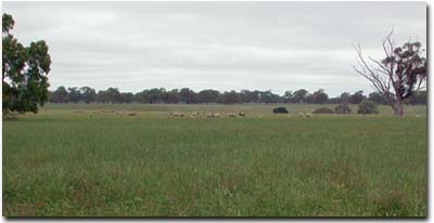 Site GL159 Landscape. |
Land Mapping Unit: Dundas Redgum.
Site Description:
Landform Pattern: Plain.
Position in Landscape: Flat.
Slope: 1%
Internal drainage: Imperfectly drained.
Soil Profile Morphology:
Surface Soil
| A1 | 0-15 cm | Very dark greyish brown (10YR3/2); loam, fine sandy to sandy clay loam; weak medium blocky structure; firm consistence (dry); very few fine ferruginous nodules; pH 5.4; abrupt to clear change to: | 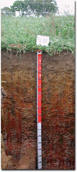 Site GL159 Profile. |
| A21 | 15-25 cm | Brown (10YR4/3); fine sandy loam; massive; firm consistence (moist); a few fine ferruginous nodules; pH 5.8; clear change to: | |
| A22 | 25-35 cm | Dark yellowish brown (10YR3/4); loam, fine sandy; massive structure; firm consistence (moist); many fine ferruginous nodules; pH 6.3; clear and wavy change to: | |
| Subsoil | |||
| B21 | 35-50 cm | Brownish yellow (10YR6/6); medium heavy clay; contains a common amount of faint coarse yellowish brown (10YR5/6) mottles; weak medium polyhedral structure; firm consistence (moist), few medium ferruginous nodules and very few coarse manganiferous nodules, pH 6.9; clear and wavy change to: | |
| B3 | 50-75 cm | Yellowish brown (10YR5/4); medium heavy clay; many prominent coarse dark red (2.5YR3/6) mottles; strong fine sub-angular blocky structure; firm consistence (moist); many medium ferruginous nodules and course manganiferous nodules common; pH 7.0; clear change to: | |
| BC | 75-180 cm | Tiger mottling present. |
Key Profile Features:
- Ferric horizons.
- Mottled subsoil.
Soil Profile Characteristics:
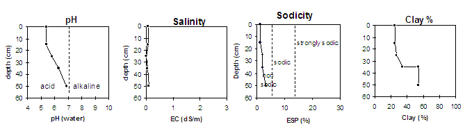
pH | Salinity Rating | |||
Surface (A1 horizon) | Strongly Acid | Low | Non-Sodic | None |
Subsoil (35-50 cm) | Slightly Acid | Low | Non-Sodic | None |
Deeper Subsoil (50-75 cm) | Neutral | Low | Non-Sodic | - |
 |
Horizon | Horizon Depth (cm) | pH (water) | pH (CaCl2) | EC 1:5 | Exchangeable Aluminium mg/kg | Exchangeable Acidity meq/100g | Exchangeable Cations | |||
Ca | Mg | K | Na | |||||||
meq/100g | ||||||||||
A1 | 0-15 | 5.4 | 4.9 | 0.06 | 13 | 14 | 7.3 | 1.3 | 0.27 | 0.14 |
A21 | 15-25 | 5.8 | 5.2 | <0.05 | <10 | 6.2 | 3.8 | 1.4 | 0.18 | 0.20 |
A22 | 25-35 | 6.3 | 5.7 | 0.05 | <10 | 6.5 | 4.1 | 2.1 | 0.15 | 0.26 |
B2 | 35-50 | 6.9 | 6.3 | 0.09 | <10 | 7.4 | 4.5 | 4.4 | 0.24 | 0.59 |
BC | 50-80 | 7.0 | 6.5 | 0.13 | ||||||
Horizon | Horizon Depth (cm) | Field Capacity pF2.5 | Wilting Point pF4.2 | Coarse Sand (0.2- 2.0 mm) | Fine Sand (0.02- 0.2 mm) | Silt (0.002- 0.02 mm) | Clay (<0.002 mm) |
A1 | 0-15 | 28 | 12 | 22 | 35 | 10 | 25 |
A21 | 15-25 | 22 | 8 | 23 | 39 | 9 | 27 |
A22 | 25-35 | 23 | 10 | 21 | 38 | 5 | 35 |
B2 | 35-50 | 32 | 17 | 15 | 24 | 2 | 54 |
BC | 50-80 |
Profile Described By: Natalie Baxter, Nathan Robinson, Grant Boyle and Mark Imhof (October 2001).
© State of Victoria (Agriculture Victoria) 1996 - .

This work, Victorian Resources Online, is licensed under a Creative Commons Attribution 4.0 licence. You are free to re-use the work under that licence, on the condition that you credit the State of Victoria (Agriculture Victoria) as author, indicate if changes were made and comply with the other licence terms.
The licence does not apply to ‘branding’ or some ‘images or photographs’ that may be owned by third parties. We ask you to seek prior approval to use images using the VRO feedback form. Access to higher quality images can also be provided on request.
This page was last updated on .