
Land Degradation
Land Degradation in South West Victoria
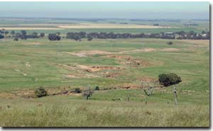 Land degradation (gullying) near Mt Challicum | Potential land degradation in Glenelg-Hopkins is mainly water erosion, including sheet, gully, tunnel and deposition, while wind erosion types include sheet and deposition. The tunnel and gully erosion maps presented here for the Glenelg-Hopkins Catchment Management Region are subsets from the original data presented in the articles on tunnel erosion and gully erosion in the Statewide VRO site, so that the accuracy of information has not been improved. |
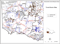 Glenelg-Hopkins Tunnel Erosion Sites | Most tunnelling was located in the west-central part of the region, particularly around the Casterton-Coleraine area, although some may have been destroyed (such as those discussed by Gibbons and Downes in 1964). On the other hand, new tunnels may have formed elsewhere and are not marked. |
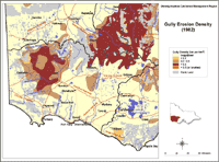 Glenelg-Hopkins Gully Erosion Density, 1982 | Similarly, the spatial distribution of gully erosion in the region may have altered since the time that the map was constructed. The highest density of gullying was >0.5 km/km2 and this extended north of the Crawford River to the regional boundary. Large patches of gully erosion in the 0.2 – 0.5 km/km2 range were found both surrounding and within the above-mentioned area, near the Wannon River west of Willaura and along the Hopkins River. The coincidence with tunnel erosion was most frequent in these two categories of gully density. An area of gully erosion < 0.2 km/km2 was mapped along the Glenelg River north of Casterton. The density of gullying was rated as ‘low’ in most of the region. |
Wind erosion
Wind erosion affects mainly fine, dry, saline and sodic soils that have poor soil structure. With salinity covering 27 472 ha (Munro, 2000) and sodic soils estimated to cover a considerable proportion of the Glenelg-Hopkins Catchment Management Region, wind erosion is a significant problem, especially during a series of dry years.
The Glenelg-Hopkins CMA soil conservation soil management program has identified the north of the catchment, in the Ararat, Lexton, and Glenthompson districts and the Casterton Land System have been to be priority areas for on ground works (RCS, 1997).
The Susceptibility to Wind Erosion map is intended to be used with existing Land Systems data to determine the likely impact of wind erosion for areas within the catchment region.The map was developed DPI/DSE's Centre for Land Protection Research (CLPR) as part of the Glenelg-Hopkins Land Resource Assessment project. Criteria are based on Lorimer (1985) and use surface texture in semi-arid to sub-humid areas and exposure to particularly strong winds in humid areas. The criterion for susceptibility to wind erosion in semi-arid areas is surface soil texture. Scores are given to rate texture from nil to high. Land characteristics and management factors involved in wind erosion | 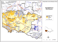 Glenelg-Hopkins Susceptibility to wind erosion |
Water erosion
A draft of the Glenelg-Hopkins Catchment Management Regional Waterway Management Strategy (GHCMA, 2001) summarised the waterway erosion studies conducted within the catchment within the Glenelg, Hopkins and Portland Drainage Basins.
The Susceptibility to Water Erosion maps are intended to be used with existing Land Systems data to determine the likely impact of wind erosion for areas within the catchment region.The maps were developed DPI/DSE's Centre for Land Protection Research (CLPR) as part of the Glenelg-Hopkins Land Resource Assessment project. | 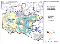 Glenelg-Hopkins Region, Susceptibility to Water Erosion (Sheet) | 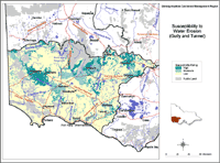 Glenelg-Hopkins Region, Susceptibility to Water Erosion (Gully & Tunnel) |
Measurement is based on McDonald et al (1990) and uses soil depth (the average depth to solid rock). Rating scores are based on observations in hilly sub-humid areas where water erosion is relatively severe. These scores are rated from nil to high. Land characteristics and management factors involved in gully and tunnel erosion. Land characteristics and management factors involved in sheet and rill erosion. Water stability. | ||
Mass Movement
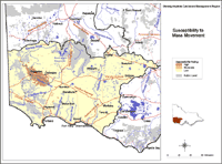 Glenelg-Hopkins Mass Movement Land characteristics and management factors involved in landslides. |  Landslips near Coleraine |
Gibbons, F.R. and Downes, R.G. (1964) `A study of the land in south-western Victoria`. Soil Conservation Authority of Victoria Technical Communication No. 3. (Government Printer: Melbourne)
© State of Victoria (Agriculture Victoria) 1996 - .

This work, Victorian Resources Online, is licensed under a Creative Commons Attribution 4.0 licence. You are free to re-use the work under that licence, on the condition that you credit the State of Victoria (Agriculture Victoria) as author, indicate if changes were made and comply with the other licence terms.
The licence does not apply to ‘branding’ or some ‘images or photographs’ that may be owned by third parties. We ask you to seek prior approval to use images using the VRO feedback form. Access to higher quality images can also be provided on request.
This page was last updated on .