
GL161
Australian Soil Classification: Mottled, Mesotrophic, Brown CHROMOSOL (confidence level 1)
General Landscape Description: Low hills.
Site Description: Upper slope (1%)
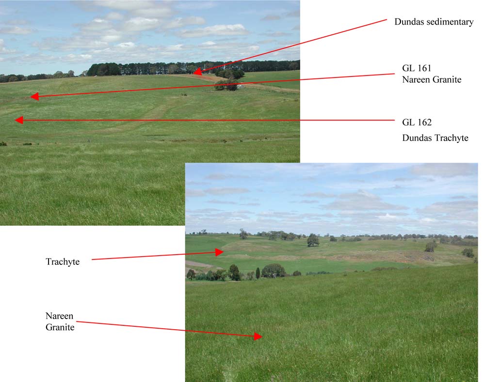
Land Unit: Nareen Granite
Geology: Ordovician granite / granodiorite
General Land Unit Description: This site is located on a granite low hill. The soils have granite parent material occurring at around one metre. Further down the slope there is a band of trachyte (GL162) outcropping. The area is a mix of geologies. This is the major soil type representing the Nareen Granite land unit, although it has not been mapped as granite due to restrictions of scale.
Soil Profile Morphology:
Horizon | Depth (cm) | |||
A1 | 0-10 | Very dark greyish brown (10YR3/2); coarse sandy loam; weak medium subangular blocky structure; very firm consistence, dry; pH 5.9; gradual change to: | 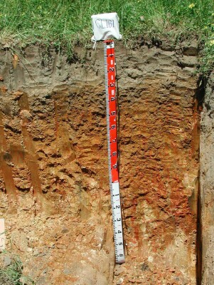 | |
A2 | 10-30 | Dark greyish brown (10YR4/2); sandy loam; weak to massive structure; very firm to strong consistence; pH 5.2; clear change to: | ||
B21 | 30-50 | Yellowish brown (10YR5/4), with many distinct coarse red (2.5YR4/6) mottles; medium heavy clay; moderate fine subangular blocky structure; strong consistence, dry; organic staining present; pH 5.6; gradual change to: | ||
B22 | 50-85 | Yellowish brown (10YR5/6), with many distinct medium dark yellowish brown (10YR4/6) mottles; medium clay; strong fine lenticular structure; strong consistence, dry; pH 6.0; diffuse change to: | ||
B23 | 85-100 | Light olive brown (10YR5/6), many prominent medium dark yellowish brown (10YR4/6) mottles; medium clay; moderate to strong lenticular to polyhedral structure (10-50 mm), consistence firm, dry; pH 6.2; gradual change to: | ||
BC | 100-150 | Weathered granite; gradual change to: | ||
C | 150-170 | Weathered granite. | ||
Soil Profile Characteristics:
Soil Profile Characteristics:
- | pH | Salinity | ||
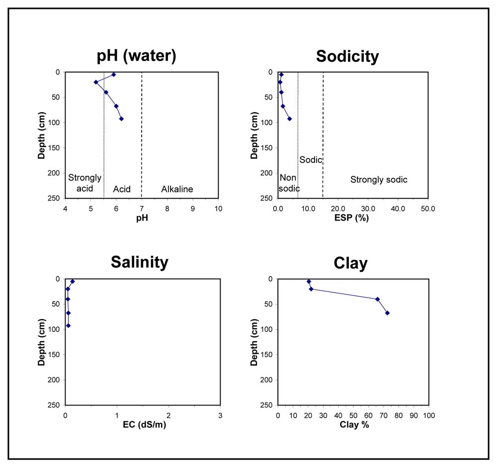
Surface Soil (A1 horizon) | Moderately Acid | Low | Non Sodic | None |
Subsoil (30-50 cm) | Moderately Acid | Very Low | Non Sodic | None |
Deeper Subsoil (85-100 cm) | Slightly Acid | Low | Non Sodic | None |
Chemical and Physical Analysis:
Horizon | Horizon Depth (cm) | pH (water) | pH (CaCl2) | EC dS/m | Organic Carbon % | Total Nitrogen % | Exchangeable Aluminium ppm | Exchangeable Acididty meq/100g | Exchangeable Cations | Coarse Sand (0.2-2.0 mm) % | Fine Sand (0.02-0.2 mm) % | Silt (0.002-0.02 mm) % | Clay (<0.002 mm) % | Field Capacity % w/w | Wilting Point % w/w | |||
Ca | Mg | K | Na | |||||||||||||||
meq/100g | ||||||||||||||||||
A1 | 0-10 | 5.9 | 5.6 | 0.14 | 5.4 | 0.34 | <10 | 9.6 | 6.3 | 1.3 | 0.74 | 0.2 | 37 | 25 | 9 | 21 | 36.7 | 12.3 |
A2 | 10-30 | 5.2 | 4.5 | <0.05 | 32 | 7.4 | 1.7 | 0.81 | 0.15 | 0.07 | 34 | 32 | 9 | 22 | 18.3 | 8.3 | ||
B21 | 30-50 | 5.6 | 4.9 | <0.05 | 14 | 8.7 | 3.3 | 3.8 | 0.21 | 0.17 | 12 | 15 | 7 | 66 | 31.0 | 21.2 | ||
B22 | 50-85 | 6.0 | 5.9 | 0.06 | <10 | 7.1 | 3.4 | 4.1 | 0.19 | 0.24 | 6 | 13 | 8 | 73 | 37.2 | 24.6 | ||
B23 | 85-100 | 6.2 | 6.0 | 0.06 | 3.4 | 0.14 | 0.31 | 43.5 | 26.3 | |||||||||
Key Profile Features:
- Strongly acidic A2 horizon
- Mottled subsoil
- Strong texture contrast between topsoil and subsoil
Profile Described By:
© State of Victoria (Agriculture Victoria) 1996 - .

This work, Victorian Resources Online, is licensed under a Creative Commons Attribution 4.0 licence. You are free to re-use the work under that licence, on the condition that you credit the State of Victoria (Agriculture Victoria) as author, indicate if changes were made and comply with the other licence terms.
The licence does not apply to ‘branding’ or some ‘images or photographs’ that may be owned by third parties. We ask you to seek prior approval to use images using the VRO feedback form. Access to higher quality images can also be provided on request.
This page was last updated on .