
Freshwater Creek Land System
Download the pdf version of this document: Freshwater Creek Land System (PDF - 244 KB)
To view the information, PDF requires the use of a PDF reader. This can be installed for free from the Adobe website (external link).
| These gently sloping plains with heavy soils are similar to many areas on the basaltic plains of Western Victoria. Unlike most pasts of the plains, this originally carried a woodland of Eucalyptus viminalis and E. ovata, which now exists mainly as roadside remnants. These species tend to be replaced by E. leucoxylon in the east and E. camaldulensis in the north, the latter species being the most common tree on the basaltic plains in western Victoria. The presence of E. viminalis and E. ovata may reflect the climate, which is wetter than is normal for basaltic plains. The main land use is sheep and beef cattle grazing. The low incidence of basaltic outcrops means that much of the area is arable, and cereal cropping is common. Minor soil salting and gully erosion occur. | 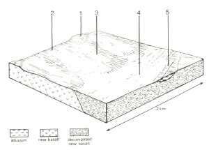 |
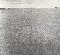 Flat or very gently undulating plains are typical of much of the basalt outcrops in western Victoria. This area carries significantly more trees than is usual on these basalt plains. | 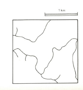 |
Area: 41 km2 | Component and its proportion of land system | ||||
1 7% | 2 10% | 3 65% | 4 15% | 5 3% | |
| CLIMATE Rainfall, mm | Annual: 600 – 650, lowest January (30), highest August (60) | ||||
Temperature, 0oC | Annual: 14, lowest July (9), highest February (19) | ||||
Temperature: less than 10oC (av.) June – July | |||||
Precipitation: less than potential evapotranspiration October – mid April | |||||
GEOLOGY Age, lithology | Pleistocene basalt with some areas of scoria and tuff | ||||
TOPOGRAPHY Landscape | Gently undulating plains in the catchment of Thompson Creek | ||||
Elevation, m | 5 – 140 | ||||
Local relief, m | 20 | ||||
Drainage pattern | Dendritic | ||||
Drainage density, km/km2 | 1.9 | ||||
| Land form | Gentle rise | Valley floor | |||
| Land form element | Cone, scarp | Upper slope, east | Middle slope | Lower slope | - |
| Slope (and range), % | 8 (6-20) | 3 (1-7) | 3 (0-6) | 2 (0-3) | 1 (0-1) |
| Slope shape | Convex | Convex | Linear | Linear | Concave |
| NATIVE VEGETATION Structure | Woodland | Open forest | Woodland | Woodland | Woodland |
| Dominant species | E. viminalis, Acacia melanoxylon, E. camaldulensis | E. viminalis, E. ovata, Casuarina stricta | E. viminalis, E. ovata, E. camaldulensis, E. leucoxylon, Casuarina stricta | E. ovata, E. viminalis, E. camaldulensis, E. leucoxylon, Casuarina stricta | E. ovata, E. viminalis, E. camaldulensis |
| SOIL Parent material | Scoria, freshly weathered basalt | In-situ deeply weathered basalt | In-situ basalt | Colluvial basaltic wash | Alluvium derived mainly from basalt |
| Description | Stony red-brown gradational soils | Mottled yellow and red duplex soils | Grey-brown duplex soils, coarse structure | Yellow sodic duplex soils | Grey gradational soils |
| Surface texture | Gravelly loam | Fine sandy loam | Fine sandy loam | Fine sandy loam | Sandy loam |
| Permeability | High | Moderate | Low | Low | Low |
| Depth, m | 0.3 | 1.8 | 1.4 | >2 | >2 |
| LAND USE | Completely cleared areas: Beef cattle grazing; dairy farming; cropping | ||||
| SOIL DETERIORATION HAZARD Critical land features, processes, forms | Stony shallow soils with low water holding capacity and impermeable rock layers are prone to sheet erosion. | Minor hazards | Dispersible subsoils are prone to gully erosion. | Sodic subsoils with low permeabilities and rising water tables lead to soil salting. Dispersible subsoils are prone to some gully erosion. | Rising saline water tables lead to waterlogging, salting and compaction. High discharge rates along watercourses lead to some streambank erosion. |
© State of Victoria (Agriculture Victoria) 1996 - .

This work, Victorian Resources Online, is licensed under a Creative Commons Attribution 4.0 licence. You are free to re-use the work under that licence, on the condition that you credit the State of Victoria (Agriculture Victoria) as author, indicate if changes were made and comply with the other licence terms.
The licence does not apply to ‘branding’ or some ‘images or photographs’ that may be owned by third parties. We ask you to seek prior approval to use images using the VRO feedback form. Access to higher quality images can also be provided on request.
This page was last updated on .