
Aire Land System
Download the pdf version of this document: Aire Land System (PDF - 603 KB)
To view the information, PDF requires the use of a PDF reader. This can be installed for free from the Adobe website (external link).
| The steeply dissected spurs and ridges in the wetter parts of the Otway Range comprise the Aire Land System, the largest land system in the study area. Rapid downcutting of streams following uplift of the Range has been responsible for forming this rugged landscape, with many slopes more than 60% and cliffs and bluffs in the central part north of Apollo Bay. The soils are young and moderately fertile. Tall open forests of Eucalyptus regnans reach heights approaching 100 m in the Calder River catchment, but most of the tallest trees have now been milled. E. obliqua and E. cypellocarpa are also common, while E. viminalis occurs in the west and E. globulus is found close to the coast. Pine forests cover large areas of this land system and other parts have been cleared for agriculture. The main hazards to land use are landslips and sheet erosion. Losses in organic matter and soil structure are often apparent following clearing. | 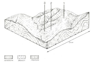 |
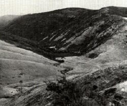 Some areas of the Aire land system have been cleared for agriculture, but the terrain is difficult to manage and many areas have become covered in bracken an non-productive scrub. | 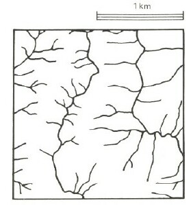 |
Area: 762 km2 | Component and its proportion of land system | ||
1 10% | 2 80% | 3 10% | |
| CLIMATE Rainfall, mm | Annual: 1,100 – 1,750, lowest January (60), highest August (170) | ||
| Temperature, 0oC | Annual: 11, lowest July (7), highest February (16) | ||
Temperature: less than 10oC (av.) May – September | |||
Precipitation: less than potential evapotranspiration December – February | |||
| GEOLOGY Age, lithology | Lower Cretaceous feldspathic sandstone and mudstone | ||
| TOPOGRAPHY Landscape | Deeply dissected hills of the Otway Range | ||
| Elevation, m | 90 – 560 | ||
| Local relief, m | 165 | ||
| Drainage pattern | Trellis pattern with isolated radial areas | ||
| Drainage density, km/km2 | 4.7 | ||
| Land form | Hill | ||
| Land form element | Crest | Upper and middle slope | Lower slope, drainage line |
| Slope (and range), % | 20 (5-30) | 40 (25-80) | 25 (5-40) |
| Slope shape | Convex | Linear | Concave |
| NATIVE VEGETATION Structure | Tall open forest | Tall open forest | Tall open forest to tall closed forest |
| Dominant species | E. obliqua, E. cypellocarpa, E. regnans, E. ovata, E. globulus, E. viminalis, Acacia melanoxylon | E. regnans, E. cypellocarpa, E. obliqua, E. ovata, E. viminalis, E. globulus | E. regnans, E. obliqua, Acacia melanoxylon, Nothofagus cunninghamii, E. cypellocarpa, E. ovata, E. viminalis, E. globulus |
| SOIL Parent material | In-situ weathered rock | In-situ weathered rock | Alluvium and colluvium |
| Description | Brown gradational soils | Brown gradational soils | Dark brown gradational soils |
| Surface texture | Loam | Loam | Loam |
| Permeability | Moderate | Moderate | High |
| Depth, m | 1.4 | 1.2 | >2 |
| LAND USE | Uncleared areas: Hardwood forestry for scantlings, posts, pole and pulpwood; softwood plantations for sawlogs and pulpwood; nature conservation; water supply; passive recreation. Minor cleared areas: Beef cattle grazing and dairy farming on mainly improved pastures; row cropping on gentler slopes. | ||
| SOIL DETERIORATION HAZARD Critical land features, processes, forms | High rainfall, moderate permeability and leaching plus loss of organic matter and soil structure upon disturbance lead to nutrient decline and soil compaction, also sheet erosion on steeper slopes. | Clay subsoils on steep slopes subject to periodic saturation are prone to landslips. Steep slopes are prone to sheet and rill erosion. High rainfall, moderate permeability and leaching plus loss of organic matters and soil structure upon disturbance lead to nutrient decline and soil compaction. | Rapid surface run-off from adjacent hills lead to scour gullying, siltation and flooding. High rainfall, high permeability and leaching plus loss of organic matter and soil structure upon disturbance lead to nutrient decline and soil compaction. |
© State of Victoria (Agriculture Victoria) 1996 - .

This work, Victorian Resources Online, is licensed under a Creative Commons Attribution 4.0 licence. You are free to re-use the work under that licence, on the condition that you credit the State of Victoria (Agriculture Victoria) as author, indicate if changes were made and comply with the other licence terms.
The licence does not apply to ‘branding’ or some ‘images or photographs’ that may be owned by third parties. We ask you to seek prior approval to use images using the VRO feedback form. Access to higher quality images can also be provided on request.
This page was last updated on .