
20.3 View Point - Emerged Platform
|
This information has been developed from the publications:
|
| Location: | 20-508183. One kilometre southwest of Point Sturt. |  View Point. Emerged platform or terrace (A). Arrows indicate abandoned gutters at rear of present sea level platform. |
Access: | Great Ocean Road. | |
Ownership: | Crown land. | |
Geomorphology: | The shore platform here has multiple ramparts similar to those at Point Sturt and Wye River (Sites 20.1 and 20.2). The platform is also backed by a terrace of similar form to Point Sturt and clearly displays abandoned platform characteristics (see Site 20.2), including a long narrow gutter (or gulch), potholes and tafoni or cavitation weathering. | |
Significance: | International. The assemblage of features make this a major site to study abandoned shoreline and inter-tidal features. As some doubt is attached to the mechanism of shore platform development, the site assumed great significance as an easily accessible one to observe these processes. |
 Abandoned gutter at rear of present shore platform at View Point. |
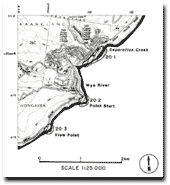 Sites 20.1, 20.2 & 20.3 |
© State of Victoria (Agriculture Victoria) 1996 - .

This work, Victorian Resources Online, is licensed under a Creative Commons Attribution 4.0 licence. You are free to re-use the work under that licence, on the condition that you credit the State of Victoria (Agriculture Victoria) as author, indicate if changes were made and comply with the other licence terms.
The licence does not apply to ‘branding’ or some ‘images or photographs’ that may be owned by third parties. We ask you to seek prior approval to use images using the VRO feedback form. Access to higher quality images can also be provided on request.
This page was last updated on .