
24.8 Parker River to Point Lewis
|
This information has been developed from the publications:
|
| Location: | 24-223970 to 243989. Coast north-east from and including Parker River Estuary. | 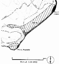 Figure 95: Sites 24.7 and 24.8 |
| Access: | Parker Hill Track and Blanket Bay Road off Cape Otway Road. | |
| Ownership: | Crown land (Otway National Park). | |
| Geology/Geomorphology: | This coastal sector is unusual in the Otway Shire as it is aligned parallel to the strike of the Mesozoic rocks which dip consistently landward at 20o between Parker River and Blanket Bay. The coast in plane view is straight without major indentations or embayments apart from the Parker River. The lower course of this river is aligned along a fault (Geol. Surv. Vic., 1973). The estuarine sector has developed where the fault zone crosses the coast allowing the stream to cut a wider valley in the fractured rock. The estuarine sector is short and largely filled by a threshold of tidal delta of inwashed sand. The Parker River enters the estuary over a series of cascades and small falls. North of the Parker River estuary the coastal slopes are formed from truncated spurs and valleys giving a "blunted" profile referred to as a steep coast. Cliffing is confined to a short basal section fronted by a relatively narrow super tidal shore platform. The profile of the platform is related to the thickness and lithology of the Mesozoic rocks, the wider sections coinciding with thicker bedded sequences. These outcrops display a variety of sedimentary structures that serve as indicators of depositional and tectonic environments of the Otway Group. The site includes an important fossil find 500 metres south of Point Lewis. Sandstone beds in the shore platform are rich in bone material and the site has yielded two dinosaur maxillae (upper jaw and teeth) and a tooth of a new species of lungfish. | |
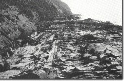 Shore platform and coastal profile north of the Parker River. |  Parker River estuary. The estuary mouth is filled by inwashed sand. | |
| Significance: | National. This is the most prolific bone site found to date in the Otway area. It is only the second Australian site from which part of a dinosaur skull is known. As the bone fragments occur over a distance of several hundred metres in the shore platform, further detailed study may reveal other important material. The physiography of the shore platform differs from the rest of the Otway area, due to the consistent landward slip of the formation and the absence of calcareous dunes (Bridgewater Formation) east of Point Franklin. The straight coastal alignment may be due to faulting suggesting that the bounding Torquay Fault may be very close inshore (Edmund Gill pers. comm.). | |
Reference: | Flannery, T. F. and Rich, T. (1982). "Dinosaur digging in Victoria with special reference to the eastern Otway Ranges." | |
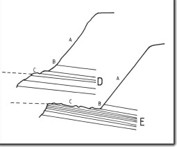 Coastal profiles north of the Parker River. Vegetated steep slope (A), basal cliff (B), shore platform (C). D indicates thick sandstone beds, and E represents thinner interbedded sandstone and siltstone. Pecked lines show high water mark. | 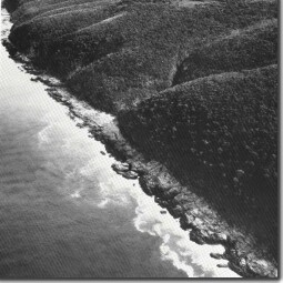 Coastal profile north of Parker River. |
© State of Victoria (Agriculture Victoria) 1996 - .

This work, Victorian Resources Online, is licensed under a Creative Commons Attribution 4.0 licence. You are free to re-use the work under that licence, on the condition that you credit the State of Victoria (Agriculture Victoria) as author, indicate if changes were made and comply with the other licence terms.
The licence does not apply to ‘branding’ or some ‘images or photographs’ that may be owned by third parties. We ask you to seek prior approval to use images using the VRO feedback form. Access to higher quality images can also be provided on request.
This page was last updated on .