
Warrion Hill
|
This information has been obtained from the report: Eruption Points of the Newer Volcanic Province of Victoria by Neville Rosengren. This report was published in 1994 and was prepared for the National Trust of Australia (Victoria) and the Geological Society of Australia (Victorian Division). The review of eruption points was based on an earlier unpublished manuscript Catalogue of the post-Miocene volcanoes of Victoria compiled by O P Singleton and E B Joyce (Geology Department, University of Melbourne 1970). |
| Location: | Labaam. | 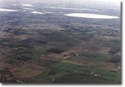 Warrion Hill. |
38 13 30S 143 32 00E (external link); 7621-4-3 (Warrion) 214662. 12 km NE of Colac. South Dreeite - Warrion Road. Colac. | ||
Land Tenure/Use: | Private land. Grazing and cropping, windbreaks, irregular outcrop, quarry. | |
Type 9: | Composite lava and scoria volcano. | |
Warrion Hill is an irregular group of scoria mounds and a broad, flat-topped lava mound with steep sides. It differs from the nearby Red Rock complex in the absence of maars and craters and it predates the Red Rock eruptions. A quarry on the lower northern slopes shows red and black scoria overlain by a thin lava flow. Extensive lava flows from the base of Warrion Hill towards the north retain original stony rise surfaces. | ||
279 m; 120 m. | ||
Regional: | This is a large eruption site with an unusually long and varied eruption history of alternating lava flows and scoria eruptions. | |
© State of Victoria (Agriculture Victoria) 1996 - .

This work, Victorian Resources Online, is licensed under a Creative Commons Attribution 4.0 licence. You are free to re-use the work under that licence, on the condition that you credit the State of Victoria (Agriculture Victoria) as author, indicate if changes were made and comply with the other licence terms.
The licence does not apply to ‘branding’ or some ‘images or photographs’ that may be owned by third parties. We ask you to seek prior approval to use images using the VRO feedback form. Access to higher quality images can also be provided on request.
This page was last updated on .