
Mount Vite Vite
|
This information has been obtained from the report: Eruption Points of the Newer Volcanic Province of Victoria by Neville Rosengren. This report was published in 1994 and was prepared for the National Trust of Australia (Victoria) and the Geological Society of Australia (Victorian Division). The review of eruption points was based on an earlier unpublished manuscript Catalogue of the post-Miocene volcanoes of Victoria compiled by O P Singleton and E B Joyce (Geology Department, University of Melbourne 1970). |
| Location: | 37 49 30S 143 11 30E (external link); 7522-3-N (Derrinallum North) 929110. 13 km N of Derinallum. Alexanders Road. | 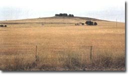 Mount Vite Vite. |
Hampden. | ||
Land Tenure/Use: | Private land. Grazing, bare with windbreak on crest. | |
Type 4: | Lava hill. | |
Mount Vite Vite is a basalt lava cone with a flat top and prominent lava ridges on the eastern side. Lava flows retain original stony rise surfaces. | ||
287 m; 30 m. | ||
Regional: | Good example of a volcano within the Skipton Plains. | |
© State of Victoria (Agriculture Victoria) 1996 - .

This work, Victorian Resources Online, is licensed under a Creative Commons Attribution 4.0 licence. You are free to re-use the work under that licence, on the condition that you credit the State of Victoria (Agriculture Victoria) as author, indicate if changes were made and comply with the other licence terms.
The licence does not apply to ‘branding’ or some ‘images or photographs’ that may be owned by third parties. We ask you to seek prior approval to use images using the VRO feedback form. Access to higher quality images can also be provided on request.
This page was last updated on .