
Red Rock (Alvie)
|
This information has been obtained from the report: Eruption Points of the Newer Volcanic Province of Victoria by Neville Rosengren. This report was published in 1994 and was prepared for the National Trust of Australia (Victoria) and the Geological Society of Australia (Victorian Division). The review of eruption points was based on an earlier unpublished manuscript Catalogue of the post-Miocene volcanoes of Victoria compiled by O P Singleton and E B Joyce (Geology Department, University of Melbourne 1970). |
| Location: | 38 15 30S 143 30 00E (external link); 7621-4-3 (Warrion) 7621-3-4 (Colac) 7521-2-1 (Nalangil) 7521-1-2 (Wool Wool) 200530. 12 km NW of Colac. Corangamite Lake Road and Red Rock Road. Colac. |
A 'virtual aerial tour' of Red Rock (Alvie) is provided in this video clip. This low quality video clip runs for 47 seconds and is 1.6 MB in size, which will take some time to automatically download if you are using a slow internet connection. We also provide a high quality version of the clip, and to view this you need to click on the 'HD' button that appears in the navigation controls for the player. This high quality version of the clip is 5.3 MB.
| Click the 'play' button and the video should display directly in your browser if this does not happen you may need to update the 'Adobe Flash Player'. This free software can be downloaded from the Adobe website (external link). |
| Land Tenure/Use: | Mainly private land. Lake surfaces are public land. Public road to two lookouts. Four sets of operating and disused quarries. Extensive exposure of pyroclastic materials i.e.scoria and tuff. |
Type 8: | Nested/buried tuff ring maar. Red Rock is one of the most complex eruption points in the Newer Volcanics Province and includes maars, tuff rings and scoria cones with a basal lava flow from another source (probably Warrion Hill). Up to 30 eruption centres have been mapped in the area measuring 4 km by 3 km just south of the township of Alvie and there are several small eruption points just north of the township. The eruption sequence includes an initial extended phase of maar and tuff ring formation with minor intervening scoria phases when phreatomagmatic activity declined due to depletion of groundwater. There are nine entire craters up to 75 m deep, some containing lakes including Lakes Purdiguluc, Werowrap and Coragulac. Lake Purdiguluc is formed by at least five coalescing eruption points. Following the maar activity there was an extended phase of scoria eruption in the north around Lake Werowrap which buried part of the maars and tuff deposits. On the basis of a single radiocarbon assay, a date of approximately 8,000 years has been advanced for the age of the Red Rock tuff eruption. 200+ m; 60 m. |
| International: | Red Rock is the most concentrated cluster of eruption points known in the Newer Volcanics Province. It shows a variety of eruption mechanisms and the craters and cones are in an excellent state of preservation. Ollier (1967a) advanced Red Rock as the type locality of “Red Rock Maars” i.e. overlapping multiple eruption points. Although the age is uncertain, it is clearly one of the most recently active volcanoes in Victoria. Of particular interest is the interleaving of volcanic ejects and lake and lunette deposits. |
| References | Skeats, E.W. & James, A.V.G. 1937. Basaltic barrier and other surface features of the Newer Basalts of western Victoria. Proceedings of the Royal Society of Victoria 49, pp. 245-278. Hills, E.S. 1940. The physiography of Victoria (1st edn). Whitcombe & Tombs, Melbourne. Ollier, C.D. & Joyce, E.B. 1964. Volcanic physiography of the Western Plains of Victoria. Proceedings of the Royal Society of Victoria 77, pp. 357-376. Ollier, C.D. 1967a. Landforms of the Newer Volcanic Province of Victoria. In J.N. Jennings & J.A. Mabbutt (eds), Landform studies from Australia and New Guinea. ANU Press, pp. 315-339. Gill, E.D. 1978. Radiocarbon dating of the volcanoes of western Victoria, Australia. Victorian Naturalist 95, pp. 152-158. Cas, R., Allen, R., Bull, S & Sukhyar, J 1984a. The Red Rock volcanic complex. Volcanics Workshop 1984, Monash University, Melbourne (unpubl). Tickell, S.J., Cummings, S, Leonard, J.G. & Withers, J.A. 1991. Colac 1:50 000 map geological report. Geological Survey of Victoria Report 89 |
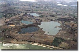 Red Rock (Alvie) viewed from the west |  Detailed map of area Detailed map of area | 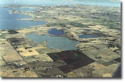 Red Rock (Alvie) viewed from the southeast. |
© State of Victoria (Agriculture Victoria) 1996 - 2025.

This work, Victorian Resources Online, is licensed under a Creative Commons Attribution 4.0 licence. You are free to re-use the work under that licence, on the condition that you credit the State of Victoria (Agriculture Victoria) as author, indicate if changes were made and comply with the other licence terms.
The licence does not apply to ‘branding’ or some ‘images or photographs’ that may be owned by third parties. We ask you to seek prior approval to use images using the VRO feedback form. Access to higher quality images can also be provided on request.
This page was last updated on 23/03/2020.