
Mount Myrtoon
|
This information has been obtained from the report: Eruption Points of the Newer Volcanic Province of Victoria by Neville Rosengren. This report was published in 1994 and was prepared for the National Trust of Australia (Victoria) and the Geological Society of Australia (Victorian Division). The review of eruption points was based on an earlier unpublished manuscript Catalogue of the post-Miocene volcanoes of Victoria compiled by O P Singleton and E B Joyce (Geology Department, University of Melbourne 1970). |
| Location: | 38 09 11S 143 14 29E (external link): 7521-4-2 (CAMPERDOWN) 964746. 12 km NE of Camperdown. Mount Myrtoon Lane. | 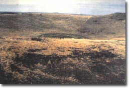 Mount Myrtoon. |
Hampden. | ||
Land Tenure/Use: | Private land. Bare, grazing and small quarry. | |
Type 5: | Scoria cone with crater. | |
The small circular scoria cone has a rim of coarse red and black scoria, agglomerate and spatter. The crater is relatively steep on both inner and outer slopes as a result of some welding of the spatter and the coarseness of the scoria. The crater is 26 m deep with a thin alluvial deposit. A small scoria pit has removed part of the southern rim. | ||
210+ m; 60 m. | ||
Regional: | This is one of a small number of scoria cones to have a well-defined enclosed crater. The rim is unusually steep with a good display of lava spatter. | |
© State of Victoria (Agriculture Victoria) 1996 - .

This work, Victorian Resources Online, is licensed under a Creative Commons Attribution 4.0 licence. You are free to re-use the work under that licence, on the condition that you credit the State of Victoria (Agriculture Victoria) as author, indicate if changes were made and comply with the other licence terms.
The licence does not apply to ‘branding’ or some ‘images or photographs’ that may be owned by third parties. We ask you to seek prior approval to use images using the VRO feedback form. Access to higher quality images can also be provided on request.
This page was last updated on .