
Mount Leura
|
This information has been obtained from the report: Eruption Points of the Newer Volcanic Province of Victoria by Neville Rosengren. This report was published in 1994 and was prepared for the National Trust of Australia (Victoria) and the Geological Society of Australia (Victorian Division). The review of eruption points was based on an earlier unpublished manuscript Catalogue of the post-Miocene volcanoes of Victoria compiled by O P Singleton and E B Joyce (Geology Department, University of Melbourne 1970). |
| Location: | 38 14 34S 143 09 23E (external link): 7521-4-2 (CAMPERDOWN) 887647. Eastern outskirts of the Town of Camperdown. Town of Camperdown; Shire of Hampden. | 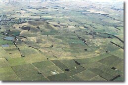 Southern section of Mount Leura Maar. |
| Land Tenure/Use: | Private land for most of the area. Small area of public land at Mount Leura scoria cone. Mount Sugarloaf is a National Trust of Australia (Victoria) property. There are two operating tuff pits on the northern tuff rim. On the north-east of Mount Leura, there are two mines for scoria and tuff. Other private land is as agricultural or residential use. | |
| Type 8: | Nested tuff ring maar. | |
Mount Leura is a scoria cone surrounding a dry crater 100 m deep and is the central and most obvious component of a larger volcanic complex southeast of the town of Camperdown. The complex includes a broad shallow maar crater measuring 2.5 km by 1.7 km, surrounded by a low tuff ring. Inside this cone are the secondary eruption points of Mount Leura and several smaller unnamed mounds and cones of scoria. These may represent eruptions along a north-south fissure. The walls of the cone are alternating layers of tuff and scoria with numerous blocks and volcanic bombs. Mount Sugarloaf is a conical mound on the south-western flank of Mount Leura. It represents a final stage of activity of the Leura volcano when a small vent ejected a large volume of lava fragments in a short time, without a change in the direction of the eruption column. This produced a steep, symmetrical, conical mound of volcanic ash, scoria and larger blocks and bombs. The scoria at Mount Leura is notable for the inclusions of high temperature megacrusts and xenoliths (fragments of the lower crust and mantle of the earth) which occur here in unusually high concentrations. | ||
310+ m; 130 m. | ||
National: | The Mount Leura complex is one of the largest maar and tuff ring volcanoes in Victoria and one of a small number of nested or complex maars in the Newer Volcanics. The relationship between the various components of the complex are very readily observed, where the Mount Leura cone and crater are the central and dominant features. Mount Sugarloaf, on the south-western rim of Mount Leura, is an unusually symmetrical scoria mound. The site provides easily accessible examples of many of the landforms produced by volcanic activity in Victoria during the late Tertiary. The peridotite xenoliths are numerous and are of international significance as examples of lower crust and upper mantle material. | |
References: | Gill, E. D. (1978). Radiocarbon dating of the volcanoes of western Victoria, Australia. Victorian Naturalist 89, pp. 188-192. Edney, W.J. & Nicholls, I.A. 1984. Mount Leura volcanic centre. Volcanics Workshop 1984, Monash University, Melbourne (unpubl.). Nicholls, I.A. (1984). Inclusions of mantle and crustal origin in basaltic deposits of the Western District. Volcanics Workshop 1984, Monash University, Melbourne (unpubl.). (Includes an extensive bibliography relating mainly to the inclusions.) | |
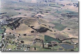 Mount Sugarloaf and crater of Mount Leura |
© State of Victoria (Agriculture Victoria) 1996 - 2025.

This work, Victorian Resources Online, is licensed under a Creative Commons Attribution 4.0 licence. You are free to re-use the work under that licence, on the condition that you credit the State of Victoria (Agriculture Victoria) as author, indicate if changes were made and comply with the other licence terms.
The licence does not apply to ‘branding’ or some ‘images or photographs’ that may be owned by third parties. We ask you to seek prior approval to use images using the VRO feedback form. Access to higher quality images can also be provided on request.
This page was last updated on 23/03/2020.