
Mount Lawaluk
|
This information has been obtained from the report: Eruption Points of the Newer Volcanic Province of Victoria by Neville Rosengren. This report was published in 1994 and was prepared for the National Trust of Australia (Victoria) and the Geological Society of Australia (Victorian Division). The review of eruption points was based on an earlier unpublished manuscript Catalogue of the post-Miocene volcanoes of Victoria compiled by O P Singleton and E B Joyce (Geology Department, University of Melbourne 1970). |
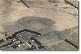
| Location: | 37 50 00S 143 53 00E (external link): 7622-2-1 (Grenville) 538084. 20 km S of Bunninyong Shelford - Mt Mercer Road. | 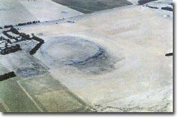 Mt Lawaluk lava disc. |
Leigh. | ||
Land Tenure/Use: | Private land. Grazing and farm property. | |
Type 3: | Lava disc. | |
This small, lava-capped mesa (flat-topped hill) has been described as a circular lava disc with steep rocky sides. There is a shallow basin on the top and prominent cliffed basalt outcrop on the north and north-east side. Ollier (1967a, 1969) cited this as an example of a lava disc, an unusual eruption whereby a single sheet of lava swells in a bulbous form from a vent - the congealed skin containing a more fluid interior - and then collapses or deflates to spread radially as a flattened or concave disc. | ||
370+ m; 30 m. | ||
State: | This site has been cited as the type example of a small lava disc. There are very few such structures described. | |
References: | Ollier, C.D. & Joyce, E.B. (1964). Volcanic physiography of the Western Plains of Victoria. Proceedings of the Royal Society of Victoria 77, pp. 357-376. Ollier, C. D. (1967a). Landforms of the Newer Volcanic Province of Victoria. In J.N. Jennings & J.A. Mabbutt (eds), Landform studies from Australia and New Guinea. ANU Press, pp. 315-339. Ollier, C.D. (1969). Volcanoes. ANU Press, Canberra. King, R.L. (1985). Explanatory note on the Ballarat 1:250 000 geological map. Geological Survey of Victoria Report 75. King, R.L. (1990b). Geological features on the Ballarat 1:250 000 sheet. Geological Survey of Victoria Unpublished Report 1990/8. | |
 Mount Lawaluk. | 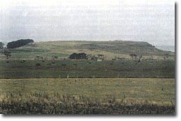 Mount Lawaluk. |
© State of Victoria (Agriculture Victoria) 1996 - .

This work, Victorian Resources Online, is licensed under a Creative Commons Attribution 4.0 licence. You are free to re-use the work under that licence, on the condition that you credit the State of Victoria (Agriculture Victoria) as author, indicate if changes were made and comply with the other licence terms.
The licence does not apply to ‘branding’ or some ‘images or photographs’ that may be owned by third parties. We ask you to seek prior approval to use images using the VRO feedback form. Access to higher quality images can also be provided on request.
This page was last updated on .