
Larundel Hill
|
This information has been obtained from the report: Eruption Points of the Newer Volcanic Province of Victoria by Neville Rosengren. This report was published in 1994 and was prepared for the National Trust of Australia (Victoria) and the Geological Society of Australia (Victorian Division). The review of eruption points was based on an earlier unpublished manuscript Catalogue of the post-Miocene volcanoes of Victoria compiled by O P Singleton and E B Joyce (Geology Department, University of Melbourne 1970). |
| Location: | Green Hill (Cargerie) | 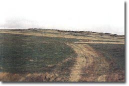 Larundel Hill. |
37 47 00S 143 56 30E (external link); 7622-2-1 (Grenville) 594125. 16 km SE of Buninyong. Mount Mercer-Elaine Road. | ||
Buninyong | ||
| Land Tenure/Use: | Private land. Cleared, irregular outcrop. | |
Type 1: | Lava cone with crater. | |
This is a small, low lava cone with a shallow crater open to the west. A ridge of lava forms an arcuate rim around the eastern side. The base contains a small swamp. | ||
10+ m; 30 m. | ||
Regional: | This is a small, low lava cone with a shallow crater open to the west. A ridge of lava forms an arcuate rim around the eastern side. The base contains a small swamp. | |
References: | Yates, H. 1954. The basalts and granitic rocks of the Ballarat district. Proceedings of the Royal Society of Victoria 66, pp. 63-101. | |
© State of Victoria (Agriculture Victoria) 1996 - .

This work, Victorian Resources Online, is licensed under a Creative Commons Attribution 4.0 licence. You are free to re-use the work under that licence, on the condition that you credit the State of Victoria (Agriculture Victoria) as author, indicate if changes were made and comply with the other licence terms.
The licence does not apply to ‘branding’ or some ‘images or photographs’ that may be owned by third parties. We ask you to seek prior approval to use images using the VRO feedback form. Access to higher quality images can also be provided on request.
This page was last updated on .