
Hardie Hill
|
This information has been obtained from the report: Eruption Points of the Newer Volcanic Province of Victoria by Neville Rosengren. This report was published in 1994 and was prepared for the National Trust of Australia (Victoria) and the Geological Society of Australia (Victorian Division). The review of eruption points was based on an earlier unpublished manuscript Catalogue of the post-Miocene volcanoes of Victoria compiled by O P Singleton and E B Joyce (Geology Department, University of Melbourne 1970). |
| Location: | 37 45 00S 143 52 60E (external link); 7622-2-1 (Grenville) 541179. 11 km S of Buninyong. | 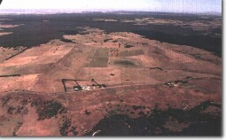 Hardie Hill. |
Buninyong. | ||
Land Tenure/Use: | Private land. Grazing, cleared scattered trees, partly drained swamp. | |
Type 7: | Tuff ring and maar crater. | |
Hardie Hill is a high point on the southern rim of a tuff ring surrounding a broad shallow maar crater. The crater measures 2.4 km x 1.6 km and opens towards the north-east with a small creek draining to the Yarrowee River. The crater floor is uneven with only a small area of swamp (now drained). There are small, shallow landslips on part of the northern wall of the crater. There are no clear exposures of material either in road cutting or natural sections. | ||
440+ m; 60 m. | ||
Regional: | Although an indistinct example of a maar, this site is in an area well north of the main development of this eruption type. There is a substantial accumulation of tuff which has built a ridge much higher than most of the southern maars. | |
References: | Yates, H. 1954. The basalts and granitic rocks of the Ballarat District. Proceedings of the Royal Society of Victoria 66, pp. 63-101. | |
© State of Victoria (Agriculture Victoria) 1996 - .

This work, Victorian Resources Online, is licensed under a Creative Commons Attribution 4.0 licence. You are free to re-use the work under that licence, on the condition that you credit the State of Victoria (Agriculture Victoria) as author, indicate if changes were made and comply with the other licence terms.
The licence does not apply to ‘branding’ or some ‘images or photographs’ that may be owned by third parties. We ask you to seek prior approval to use images using the VRO feedback form. Access to higher quality images can also be provided on request.
This page was last updated on .