
Lake Elingamite
|
This information has been obtained from the report: Eruption Points of the Newer Volcanic Province of Victoria by Neville Rosengren. This report was published in 1994 and was prepared for the National Trust of Australia (Victoria) and the Geological Society of Australia (Victorian Division). The review of eruption points was based on an earlier unpublished manuscript Catalogue of the post-Miocene volcanoes of Victoria compiled by O P Singleton and E B Joyce (Geology Department, University of Melbourne 1970). |
| Location: | 38 21 24S 143 00 20E (external link); 7521-3-4 (Cobden) & 7421-2-1 (Dixie) 752527. 5 km SW of Cobden. Oates Road and Rohans Road. | 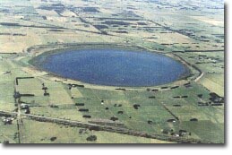 Lake Elingamite. |
Heytesbury. | ||
| Land Tenure/Use: | Public land (lake and shoreline). Public boat ramp. Most of tuff ring and higher level lake shoreline is in private land. Pasture and grazing. | |
Type 7: | Tuff ring and maar crater. | |
Lake Elingamite is an almost perfectly circular maar 2 km in diameter which is completely enclosed by a tuff ring. The tuff ring rises to 15 m on the eastern side as a narrow ridge but on the west of the lake is lower and broader. The inner edge of the tuff ring is steep. This is unlikely to be initial explosion or collapse slope but rather a fossil cliff line eroded by wave action at higher lake levels. | ||
140+ m; 15 m. | ||
Regional: | Lake Elingamite is a classical example of a simple maar or “Pulvermaar”. It displays different topography from other small maars with the even rim and steep inner cliffs. Much of the site is public land. The deposits of the lake floor have not been investigated but are likely to contain sedimentary/organic material that may be used to date the age of the eruption and are significant for palaeoclimatic studies of western Victoria. | |
References: | Ollier, C.D. & Joyce, E.B. 1964. Volcanic physiography of the Western Plains of Victoria. Proceedings of the Royal Society of Victoria 77, pp 357-376. Ollier , C.D.1967b. Maars: their characteristics, varieties and definition. Bulletin volcanologique 31, pp. 45-73. | |
© State of Victoria (Agriculture Victoria) 1996 - .

This work, Victorian Resources Online, is licensed under a Creative Commons Attribution 4.0 licence. You are free to re-use the work under that licence, on the condition that you credit the State of Victoria (Agriculture Victoria) as author, indicate if changes were made and comply with the other licence terms.
The licence does not apply to ‘branding’ or some ‘images or photographs’ that may be owned by third parties. We ask you to seek prior approval to use images using the VRO feedback form. Access to higher quality images can also be provided on request.
This page was last updated on .