
Mount Buninyong
|
This information has been obtained from the report: Eruption Points of the Newer Volcanic Province of Victoria by Neville Rosengren. This report was published in 1994 and was prepared for the National Trust of Australia (Victoria) and the Geological Society of Australia (Victorian Division). The review of eruption points was based on an earlier unpublished manuscript Catalogue of the post-Miocene volcanoes of Victoria compiled by O P Singleton and E B Joyce (Geology Department, University of Melbourne 1970). |
| Location: | 37 39 17S 143 55 27E (external link); 7622-1-2 (Yendon) 580285. 3 km E of Buninyong. Mount Buninyong Road. | 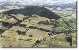 Mount Buninyong. |
Buninyong. | ||
Land Tenure/Use: | Public land on upper parts of this site. Private land at base. Public road to lookout and communications towers at summit. Outcrop only in road cuts. | |
Type 9: | Composite lava and scoria cone. | |
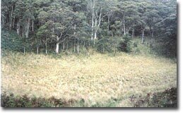
Mount Buninyong is a composite breached scoria cone from which issued a number of lava flows. There is a deep, well-defined central crater which has been breached on the north-western side. On the eastern side, the cone rises abruptly above older weathered lava flows but the topography around the western side is irregular as younger lava flows issued from here via the explosive breach of the cone. The breach may thus represent the site of a second crater. Small parasitic lava vents occur around the base. With over 200 m of local relief, Mount Buninyong is one of the highest scoria cones in Victoria. The lavas include olivine-rich xenoliths and megacrysts of clinopyroxene. Road cuttings expose coarse volcanic agglomerate and thin pods of lava. | ||
745 m; 200+ m. | ||
State: | Mount Buninyong is one of the most distinctive volcanic features of the Central Highlands group of Newer Volcanics. It is an excellent example of a composite volcano and the most obvious example in Victoria of a breached scoria cone and associated lava flows. It illustrates well the varied topography developed on adjacent lava flows of different ages. It is the only major scoria cone with a deep crater that is substantially in public ownership and has not been quarried. It is one of the few scoria eruption points to retain a natural woodland cover. Megacryst site. | |
References: | Yates, H. 1954. The basalts and granitic rocks of the Ballarat district. Proceedings of the Royal Society of Victoria 66, pp. 63-101. King, R.L. 1990b. Geological features on the Ballarat 1:250 000 sheet. Geological Survey of Victoria Unpublished Report 1990/8. | |
 Mount Buninyong |
© State of Victoria (Agriculture Victoria) 1996 - .

This work, Victorian Resources Online, is licensed under a Creative Commons Attribution 4.0 licence. You are free to re-use the work under that licence, on the condition that you credit the State of Victoria (Agriculture Victoria) as author, indicate if changes were made and comply with the other licence terms.
The licence does not apply to ‘branding’ or some ‘images or photographs’ that may be owned by third parties. We ask you to seek prior approval to use images using the VRO feedback form. Access to higher quality images can also be provided on request.
This page was last updated on .