
OTR499
Australian Soil Classification: Humose-Mottled, Melacic, Red KANDOSOL Bleached-Sodic, Eutrophic, Black Kurosol
Northcote Factual Key: Dd1.41
General Landscape Description: Low hills, dissected plateau
Site Description: Hillslope - mid slope Slope: 0%
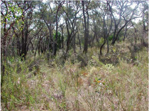
Native Vegetation: E.obliqua, A.suaveolens Xanthorrhea australis, Heath spp.
Geology: Ted: Paleogene (Tertiary) marine sediments; silt, fine sand, clay (Demons Bluff Formation)
 |
Soil Profile Morphology:
Surface Soil
| A1 | 0-10 cm | Black (10YR2/1); loamy fine sand; apedal single grain structure; gradual boundary to: | |
| A2 | 10-30 cm | Grey (10YR5/1); loamy fine sand; apedal single grain structure; clear wavy boundary to: | |
| Subsoil | |||
| B21 | 30-50 cm | Very dark greyish brown (10YR3/2); sandy clay loam; weak coarse subangular blocky structure; organic stains on ped faces; diffuse boundary to: | |
| B22 | 50-120 cm | Dark yellowish brown (10YR4/4); sandy clay loam; coarse subangular blocky structure; clay skin cutans; diffuse boundary to: | |
| C | 120+ cm | Yellowish brown (10YR5/6); sandy clay; apedal massive structure. | |
Soil Profile Characteristics:
Salinity Rating | |||
Surface (A1 horizon) | Very Strongly Acid | Low | Non-Sodic |
Subsoil (B21 horizon) | Strongly Acid | Very Low | Non-Sodic |
Deeper Subsoil (at 120 cm) | Strongly Acid | Medium | Sodic |

| The surface is very strongly acid. The subsoil is strongly acid. | The salinity rating in the surface is low. The upper subsoil has a salinity rating of very low. Salinity rating increases to medium in the deeper subsoil. | This profile is non-sodic until about 100 cm, when it becomes sodic. | Low clay content at the surface. Sharp increase in clay content at the A/B interface. |
| Horizon | Horizon Depth (cm) | pH (water) | EC dS/m | Organic Carbon % | Total N % | P ppm | K ppm | Free Fe % | Exchangeable Cations | Total Bases cmolc/kg | Ex Ac cmolc/kg | CEC cmolc/kg | |||
| Ca | Mg | K | Na | ||||||||||||
| cmolc/kg | |||||||||||||||
| A1 | 0-10 | 4.7 | 0.052 | 3.1 | 0.14 | 5 | 70 | 0.1 | 2.5 | 0.9 | 0.1 | 0.04 | 3.5 | 7.6 | 10.1 |
| A2 | 10-20 | 4.6 | 0.037 | 1.2 | 0.060 | 4 | 30 | 0.1 | 0.9 | 0.2 | 0.07 | 0.01 | 1.2 | 2.6 | 3.8 |
| A2 | 20-30 | 4.9 | 0.021 | 0.7 | 0.033 | 3 | 20 | 0.1 | 0.5 | 0.3 | 0.03 | 0.01 | 0.8 | 0.8 | 1.6 |
| B21 | 40-50 | 5.3 | 0.060 | 5 | 100 | 2.2 | 1.2 | 2.5 | 0.2 | 0.2 | 4.1 | 7.2 | 11.4 | ||
| 50-60 | 5.5 | 0.084 | 3 | 140 | 1.3 | 3.9 | 0.2 | 0.4 | 5.8 | 7.1 | 11.7 | ||||
| 80-90 | 5.5 | 0.108 | 3 | 80 | 0.4 | 1.7 | 0.08 | 0.2 | 2.4 | 3.7 | 6.0 | ||||
| B22 | 110-120 | 5.2 | 0.258 | 2 | 60 | 0.9 | 3.3 | 0.1 | 0.8 | 5.1 | 3.0 | 8.0 | |||
| Horizon | Horizon Depth (cm) | Coarse Sand (0.2-2.0 mm) | Fine Sand (0.02-0.2 mm) | Silt (0.002-0.02 mm) | Clay (<0.002 mm) |
| A1 | 0-10 | 1 | 83 | 6 | 7 |
| A2 | 10-20 | 1 | 84 | 10 | 6 |
| A2 | 20-30 | <1 | 90 | 3 | 7 |
| B21 | 40-50 | 1 | 69 | 5 | 22 |
| 50-60 | <1 | 60 | 2 | 33 | |
| 80-90 | <1 | 69 | 4 | 23 | |
| B22 | 110-120 | <1 | 65 | 4 | 29 |
© State of Victoria (Agriculture Victoria) 1996 - .

This work, Victorian Resources Online, is licensed under a Creative Commons Attribution 4.0 licence. You are free to re-use the work under that licence, on the condition that you credit the State of Victoria (Agriculture Victoria) as author, indicate if changes were made and comply with the other licence terms.
The licence does not apply to ‘branding’ or some ‘images or photographs’ that may be owned by third parties. We ask you to seek prior approval to use images using the VRO feedback form. Access to higher quality images can also be provided on request.
This page was last updated on .