
OTR497
Australian Soil Classification: Humose-Mottled, Melacic, Red Acidic-Sodic, Eutrophic, Yellow KANDOSOL
Northcote Factual Key: Gn2.81
General Landscape Description: Low Hills, Hills
Site Description: Mid Slope Slope: 18% Aspect: East
Native Vegetation: E. sideroxylon, A. verticillatta
Geology: Tpb: Neogene (Tertiary) fluvial sediments; gravel, sand, silt (Brighton Group) [Tae: Paleogene (Tertiary) fluvial sediments; gravel, sand, clay, brown coal. (Eastern View Formation)].
Soil Profile Morphology:
Surface Soil
| A1 | 0-10 cm | Very dark greyish brown (10YR3/2); fine sandy loam; single grain structure; a few; pH 4.5; clear change to: | |
| A2 | 10-20 cm | Brown (10YR5/3); fine sandy loam; apedal, single grain structure; pH 4.7; gradual change to: | |
| A3 | 20-30 cm | Yellowish brown (10YR5/4); fine sandy clay loam; weak fine subangular blocky structure; pH 4.9; diffuse change to: | |
| Subsoil | |||
| B2 | 30-90 cm | Brownish yellow (10YR6/6) to light yellowish brown (10YR6/4); light clay; weak fine to very fine subangular blocky structure; a few ferruginous nodules; pH 5.3; diffuse irregular change to: | |
| C | 90+ cm | Yellow; sandy clay; apedal, single grain structure. | |
Soil Profile Characteristics:
Salinity Rating | |||
Surface (A1 horizon) | Very Strongly Acid | Very Low | Non Sodic |
Subsoil (B2 horizon) | Strongly Acid | High | Strongly Sodic |
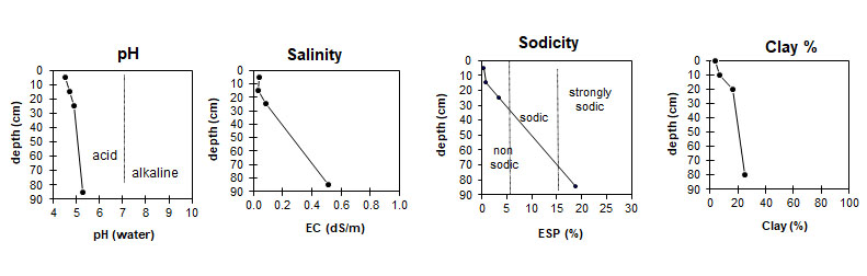
| The surface is very strongly acid. The subsoil is strongly acid. | The salinity rating in the A horizons is very low. The subsoil has a high salinity rating. | The A horizons are non-sodic. The subsoil is strongly sodic. | The clay content is very low in the surface, and moderate at depth. |
Horizon | Horizon Depth (cm) | pH (water) | EC dS/m | Cl % | Organic Carbon % | Total N % | P ppm | K ppm | Free Fe % | Exchangeable Cations | Total Bases cmolc/kg | Ex Ac cmolc/kg | CEC cmolc/kg | |||
Ca | Mg | K | Na | |||||||||||||
cmolc/kg | ||||||||||||||||
A1 | 0-10 | 4.5 | 0.037 | 0.015 | 1.4 | 0.004 | 5 | 120 | 0.3 | 5.4 | 1.9 | 0.3 | 0.1 | 7.7 | 10.8 | 18.5 |
A2 | 10-20 | 4.7 | 0.032 | 0.019 | 1.3 | 0.002 | 3 | 80 | 0.3 | 1.6 | 0.9 | 0.2 | 0.07 | 2.77 | 4.73 | 7.5 |
A3 | 20-30 | 4.9 | 0.083 | 0.017 | 1.1 | 0.007 | 2 | 60 | 1.1 | 0.6 | 1.7 | 0.1 | 0.2 | 2.6 | 2.9 | 5.5 |
B2 | 80 - 90 | 5.3 | 0.510 | 0.047 | 0.7 | 0.064 | 2 | 40 | 1.9 | 0.4 | 3.5 | 0.1 | 1.2 | 5.6 | 0.8 | 6.4 |
Horizon | Horizon Depth (cm) | Gravel % | Coarse Sand (0.2-2.0 mm) | Fine Sand (0.02-0.2 mm) | Silt (0.002-0.02 mm) | Clay (<0.002 mm) |
A1 | 0-10 | 4 | 19 | 52 | 20 | 4 |
A2 | 10-20 | 2 | 14 | 53 | 25 | 7 |
A3 | 20-30 | 3 | 10 | 50 | 24 | 16 |
B2 | 80 - 90 | <1 | 5 | 44 | 24 | 25 |
Profile Described By: Andrew Thornley, 21st August 1969.
© State of Victoria (Agriculture Victoria) 1996 - .

This work, Victorian Resources Online, is licensed under a Creative Commons Attribution 4.0 licence. You are free to re-use the work under that licence, on the condition that you credit the State of Victoria (Agriculture Victoria) as author, indicate if changes were made and comply with the other licence terms.
The licence does not apply to ‘branding’ or some ‘images or photographs’ that may be owned by third parties. We ask you to seek prior approval to use images using the VRO feedback form. Access to higher quality images can also be provided on request.
This page was last updated on .