
OTR 426
Australian Soil Classification: Acidic, Lithosolic, Clastic RUDOSOL
Northcote Factual Key: Uc2.2
General Landscape Description: Hills
Site Description: Hillslope - midslope Slope: 2% Aspect: North
Geology: Tan: Palaeocene (Tertiary) braided stream deposits; quartz gravel, sand (Wiridgil Gravel)
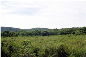 Heathy vegetation south of Chapple Vale |
Soil Profile Morphology:
Surface Soil
| A11 | 0-1 cm | Black (10YR2/1); sandy loam; weak subangular blocky structure; abundant quartz gravel; clear boundary to: | |
| A12 | 1-30 cm | Very dark grey (10YR3/1); sandy loam; weak subangular blocky structure; abundant quartz gravel; clear boundary to: | |
| Subsoil | |||
| C | 30+ cm | Light grey (l0YR7/ 1), merging to white (10YR8/1); loamy coarse sand; apedal single grain structure; abundant quartz gravel and occasional stones. | |
Soil Profile Characteristics:
Salinity Rating | |||
Surface (A1 horizon) | Extremely Acid | Low | Non-Sodic |
Subsoil (Upper C horizon) | Very Strongly Acid | Low to Medium | Non-Sodic |
Deeper Subsoil (at 120 cm) | Strongly Acid | Low to Medium | Non-Sodic |
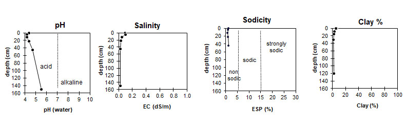
| The surface is extremely acid. The upper C horizon is very strongly acid, becoming strongly acid with depth. | The salinity rating in the surface is low. The C horizon has a low to medium salinity rating. | This profile non-sodic. | The clay content is very low. |
Horizon | Horizon Depth (cm) | pH (water) | EC dS/m | Cl % | Organic Carbon % | Total N % | P ppm | K ppm | Free Fe % | Exchangeable Cations | Total Bases cmolc/kg | Ex Ac cmolc/kg | CEC cmolc/kg | |||
Ca | Mg | K | Na | |||||||||||||
cmolc/kg | ||||||||||||||||
A11 | 0-1 | 4.4 | 0.094 | 0.009 | 9.0 | 0.34 | 9 | 120 | 0.2 | 4.7 | 2.0 | 0.3 | 0.3 | 7.3 | 15.4 | 22.7 |
A12 | 1-8 | 4.2 | 0.100 | 0.006 | 6.8 | 0.24 | 7 | 70 | 0.1 | 2.3 | 1.7 | 0.2 | 0.2 | 4.4 | 16.0 | 20.3 |
A12 | 8-15 | 4.2 | 0.052 | 0.005 | 3.6 | 0.11 | 4 | 60 | <0.1 | 1.4 | 0.8 | 0.1 | 0.1 | 2.4 | 9.7 | 12.1 |
A12 | 15-30 | 4.4 | 0.035 | 0.003 | 1.5 | 0.048 | 3 | 40 | <0.1 | 0.6 | 0.4 | 0.08 | 0.06 | 1.1 | 5.1 | 6.2 |
C | 30-60 | 4.7 | 0.024 | 0.002 | 0.5 | 0.017 | <0.1 | 0.4 | <0.05 | 0.07 | 0.03 | 0.5 | 2.0 | 2.54 | ||
C | 120-180 | 5.5 | 0.022 | 0.001 | 0.1 | 0.03 | <0.1 | |||||||||
Horizon | Horizon Depth (cm) | Gravel % | Coarse Sand (0.2-2.0 mm) | Fine Sand (0.02-0.2 mm) | Silt (0.002-0.02 mm) | Clay (<0.002 mm) |
A11 | 0-1 | 5 | 68 | 13 | 4 | 6 |
A12 | 1-8 | 5 | 66 | 15 | 5 | 5 |
A12 | 8-15 | 6 | 70 | 19 | 4 | 3 |
A12 | 15-30 | 10 | 73 | 19 | 5 | 2 |
C | 30-60 | 14 | 68 | 24 | 4 | 1 |
C | 120-180 | 16 | 80 | 14 | 3 | 2 |
Management Considerations:
The deep sandy soils (associated with the sand and gravel parent lithology) generally have poor plant water/nutrient holding capacity. The soils are particularly prone to wind, sheet and rill erosion. The upper soil horizons may be hydrophobic (in conjunction with organic coatings) when dried out, taking time to reabsorb moisture. These soils do however drain rapidly.
Acid soil pH is often associated with sandy surfaces due the lack of base minerals and may or may not have organic matter (humose or peaty surfaces). This acidic nature restricts the uptake of certain nutrients as well as intolerance for some plant species (due in part to the increasing mobilisation of aluminium and manganese).
Profile Described By: Frank Gibbons, 1969.
© State of Victoria (Agriculture Victoria) 1996 - .

This work, Victorian Resources Online, is licensed under a Creative Commons Attribution 4.0 licence. You are free to re-use the work under that licence, on the condition that you credit the State of Victoria (Agriculture Victoria) as author, indicate if changes were made and comply with the other licence terms.
The licence does not apply to ‘branding’ or some ‘images or photographs’ that may be owned by third parties. We ask you to seek prior approval to use images using the VRO feedback form. Access to higher quality images can also be provided on request.
This page was last updated on .