
OTR424
Australian Soil Classification: Humose-Mottled, Melacic, Red KANDOSOL
Northcote Factual Key: GN2.41
General Landscape Description: Mountains, Hills
Site Description: Lower Slope Slope: 5% Aspect: South
Native Vegetation: E. regnans, E. obliqua, E. gonicalyx, A. melanoxylon
Geology: Kl: Cretaceous Sediments; Felspathic Sandstone
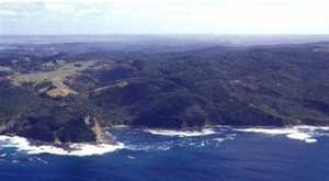
Moonlight Heads
Soil Profile Morphology:
Surface Soil
| A11 | 0-8 cm | Black (10YR2/1); fine sandy loam; crumb structure; clear wavy boundary to: | |
| A12 | 8-15 cm | Very dark greyish brown (10YR3/2); sandy loam; weak subangular blocky structure; occasional angular sandstone; clear wavy boundary to: | |
| A2 | 15-30 cm | Yellowish brown (10YR5/6); fine sandy clay loam; very weak subangular blocky structure; occasional angular sandstones; clear boundary to: | |
| Subsoil | |||
| B2 | 30-60 cm | Dark greyish brown (10YR4/2); heavy clay; strong very fine subangular blocky structure; occasional angular sandstones; gradual irregular boundary to: | |
| B3 | 60-90 cm | Dark greyish brown (10YR4/2); fine sandy clay; moderate angular blocky structure; discontinuous layers of decomposing rock; gradual irregular boundary to: | |
| C | 90+ cm | Weathering dipping beds of sandstones and mudstones with thin lenses of dark greyish brown (10YR4/2) clay down joint plains. | |
Soil Profile Characteristics:
Salinity Rating | |||
Surface (A1 horizon) | Strongly Acid | Medium | Non-Sodic |
Subsoil (B21 horizon) | Strongly Acid | Low | Non-Sodic |
Deeper Subsoil (at 90 cm) | Strongly Acid | Low | Slightly Sodic |
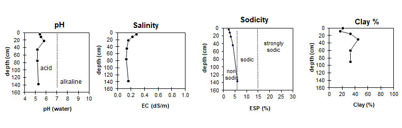
This profile is strongly acid. | The salinity rating in the surface is medium. The subsoil has a low salinity rating. | This profile is non-sodic down to the deeper subsoil where the soil is slightly sodic. | Low to moderate clay content. |
Horizon | Horizon Depth (cm) | pH (water) | EC dS/m | Cl % | Organic Carbon % | Total N % | P ppm | K ppm | Free Fe % | Exchangeable Cations | Total Bases cmolc/kg | Ex Ac cmolc/kg | CEC cmolc/kg | |||
Ca | Mg | K | Na | |||||||||||||
cmolc/kg | ||||||||||||||||
A11 | 0-8 | 5.4 | 0.28 | 0.025 | 5.1 | 0.37 | 11 | 260 | 1.4 | 8.5 | 4.3 | 0.9 | 0.6 | 14.3 | 11.3 | 25.7 |
A12 | 8-15 | 5.5 | 0.22 | 0.021 | 2.8 | 0.19 | 4 | 200 | 1.1 | 5.9 | 3.4 | 0.6 | 0.5 | 10.4 | 7.4 | 17.7 |
A2 | 15-30 | 5.8 | 0.16 | 0.014 | 1.3 | 0.093 | 2 | 240 | 2.4 | 7.7 | 5.0 | 0.8 | 0.6 | 14.1 | 4.4 | 18.5 |
B2 | 30-60 | 5.2 | 0.14 | 0.014 | 0.6 | 0.060 | 1 | 220 | 4.7 | 5.0 | 8.8 | 0.8 | 1.1 | 15.7 | 10.3 | 25.7 |
B3 | 60-90 | 5.2 | 0.13 | 0.014 | 0.4 | 0.040 | 5.4 | |||||||||
C | 90-185 | 5.3 | 0.16 | 0.015 | 0.4 | 0.035 | 2 | 200 | 2.1 | 1.4 | 13.8 | 0.7 | 1.7 | 17.6 | 9.9 | 27.5 |
Horizon | Horizon Depth (cm) | Gravel % | Coarse Sand (0.2-2.0 mm) | Fine Sand (0.02-0.2 mm) | Silt (0.002-0.02 mm) | Clay (<0.002 mm) |
A11 | 0-8 | 8 | 6 | 45 | 20 | 21 |
A12 | 8-15 | 2 | 7 | 48 | 22 | 17 |
A2 | 15-30 | 3 | 3 | 41 | 20 | 33 |
B2 | 30-60 | 2 | 2 | 34 | 20 | 45 |
B3 | 60-90 | 5 | 4 | 48 | 13 | 33 |
C | 90-185 | 1 | 2 | 47 | 16 | 33 |
Management Considerations:
Strong texture contrast between the surface soil (sandy loam) and the subsoil (heavy clay) may reduce and/or redirect the internal drainage and restrict root growth beyond the upper horizons.
Acidic subsoils generally occur on acidic parent material or where there has been sufficient leaching of the soil. These subsoils affect nutrient availability, creating a nutrient imbalance and the potential for aluminium and manganese toxicity.
Deficiencies of calcium, potassium and molybdenum are likely.
Profile Described By: Frank Gibbons, 28th January 1966.
© State of Victoria (Agriculture Victoria) 1996 - .

This work, Victorian Resources Online, is licensed under a Creative Commons Attribution 4.0 licence. You are free to re-use the work under that licence, on the condition that you credit the State of Victoria (Agriculture Victoria) as author, indicate if changes were made and comply with the other licence terms.
The licence does not apply to ‘branding’ or some ‘images or photographs’ that may be owned by third parties. We ask you to seek prior approval to use images using the VRO feedback form. Access to higher quality images can also be provided on request.
This page was last updated on .