
OTR418
Australian Soil Classification: Humose-Acidic, Mesotrophic, Brown DERMOSOL
Northcote Factual Key: Gn3.21
General Landscape Description: Mountains, Hills
Site Description: Ridge Slope Aspect: South
Native Vegetation: E. regnans, A. melanoxylon, Pomaderris spp.
Geology: Kl: Cretaceous Fluvial Sediments; Felspathic Sandstone, Siltstone, Mudstone (Eumeralla Formation).
Soil Profile Morphology:
Surface Soil
| A11 | 0-8 cm | Very dark brown (10YR2/2); loam; strong very fine crumb structure; pH 5.0; abrupt change to: | |
| A12 | 8-30 cm | Dark brown (7.5YR3/2); clay loam; moderate fine subangular blocky structure; pH 4.8; gradual change to: | |
| Subsoil | |||
| B21 | 30-75 cm | Dark brown (10YR3/4); medium clay; moderate medium subangular blocky structure; weak to firm consistence; pH 5.0; diffuse change to: | |
| B22 | 75-140 cm | Yellowish brown (10YR5/6); light clay; weak subangular blocky structure; weak to firm consistence; a few sandstone gravels; pH 4.9; diffuse change to: | |
| C | 140 + cm | Weathered sandstone. | |
Soil Profile Characteristics:
Salinity Rating | |||
Surface (A1 horizon) | Very Strongly Acid | Medium | Non-Sodic |
Subsoil (B21 horizon) | Strongly Acid | Low | Non-Sodic |
Deeper Subsoil (at 90 cm) | Very Strongly Acid | Medium | Non-Sodic |
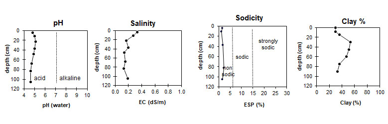
| The surface and deeper subsoil is very strongly acid. The B21 horizon is strongly acid. | The salinity rating is medium except for the B21 horizon where it is low. | This profile is non-sodic. | The clay content is moderate and is at its highest in the B21 horizon. |
Horizon | Horizon Depth (cm) | pH (water) | EC dS/m | Cl % | Organic Carbon % | Total N % | P ppm | K ppm | Free Fe % | Exchangeable Cations | Total Bases cmolc/kg | Ex Ac cmolc/kg | CEC cmolc/kg | |||
Ca | Mg | K | Na | |||||||||||||
cmolc/kg | ||||||||||||||||
A11 | 0 - 8 | 4.8 | 0.330 | 0.026 | 8.1 | 0.66 | 18 | 320 | 3.5 | 4.3 | 5.4 | 0.9 | 0.4 | 11.0 | 15.3 | 26.3 |
A12 | 8 - 15 | 5.0 | 0.270 | 0.028 | 5.3 | 0.46 | 10 | 260 | 3.7 | 3.4 | 4.0 | 0.7 | 0.3 | 8.4 | 16.2 | 24.5 |
15 - 30 | 5.1 | 0.170 | 0.017 | 3.1 | 0.26 | 5.3 | ||||||||||
B21 | 30 - 45 | 5.0 | 0.200 | 0.025 | 1.9 | 0.15 | 140 | 5.8 | 1.5 | 1.6 | 0.4 | 0.3 | 3.8 | 13.3 | 17.0 | |
45 - 60 | 4.9 | 0.140 | 0.018 | 1.2 | 0.097 | 6.0 | ||||||||||
60-75 | 4.7 | 0.150 | 0.022 | 0.8 | 0.067 | 5.5 | ||||||||||
B22 | 75-90 | 4.6 | 0.130 | 0.020 | 0.5 | 0.045 | 100 | 4.8 | 0.6 | 0.8 | 0.3 | 0.3 | 2.0 | 11.1 | 13.0 | |
90 - 120 | 4.6 | 0.190 | 0.030 | 0.5 | 0.043 | 160 | 3.9 | 0.7 | 0.9 | 0.4 | 0.2 | 2.2 | 11.1 | 13.0 | ||
Horizon | Horizon Depth (cm) | Gravel % | Coarse Sand (0.2-2.0 mm) | Fine Sand (0.02-0.2 mm) | Silt (0.002-0.02 mm) | Clay (<0.002 mm) |
A11 | 0 - 8 | 2 | 6 | 30 | 23 | 30 |
A12 | 8 - 15 | 5 | 32 | 27 | 30 | |
15 - 30 | 3 | 27 | 28 | 36 | ||
B21 | 30 - 45 | 3 | 3 | 24 | 14 | 53 |
45-60 | 6 | 6 | 26 | 15 | 51 | |
60-75 | 6 | 6 | 30 | 14 | 47 | |
B22 | 75-90 | 5 | 5 | 41 | 15 | 36 |
90 - 120 | 4 | 4 | 45 | 15 | 33 |
Profile Described By: Frank Gibbons, 12th January 1966.
Profile Described By:
© State of Victoria (Agriculture Victoria) 1996 - .

This work, Victorian Resources Online, is licensed under a Creative Commons Attribution 4.0 licence. You are free to re-use the work under that licence, on the condition that you credit the State of Victoria (Agriculture Victoria) as author, indicate if changes were made and comply with the other licence terms.
The licence does not apply to ‘branding’ or some ‘images or photographs’ that may be owned by third parties. We ask you to seek prior approval to use images using the VRO feedback form. Access to higher quality images can also be provided on request.
This page was last updated on .