
OTR413
Australian Soil Classification: Melacic, Pipey, Aeric PODOSOL
Northcote Factual Key: Uc2.34
General Landscape Description: Dissected Coastal Plain
Site Description: Flat Slope: 1%
Native Vegetation: Tall Wet Scrub; Woolly Tea-Tree
Geology: Quaternary Lacustrine/Alluvium
Soil Profile Morphology:
Surface Soil
| A11 | 0-7 cm | Black (10YR2/1); fine sandy loam; strong fine crumb structure; pH 5.7; clear boundary to: | |
| A12 | 7-25 cm | Black (10YR2/1); fine sandy loam, silty; strong medium blocky structure; pH 6.6; clear and tongued boundary to: | |
| A2 | 25-45 cm | Grey (10YR5/1), with faint yellowish brown (10YR5/4) mottles; loam, fine sandy; apedal massive structure; pH 7.1; clear boundary to: | |
| Subsoil | |||
| B21 | 45-68 cm | Light brownish grey (10YR6/2), with yellowish brown (10YR5/4) and (10YR5/8) mottles; loam fine sandy, silty; apedal massive structure; pH 7.2; abrupt boundary to: | |
| B22 | 68 + cm | Grey (2.5Y5/1 and 2.5Y6/1), with yellowish brown (10YR5/8) mottles; fine sand, silty; apedal massive structure; pH 7.2. | |
Soil Profile Characteristics:
Salinity Rating | |||
Surface (A1 horizon) | Moderately Acid | Low | Non-Sodic |
Subsoil (B21 horizon) | Slightly Alkaline | Low | Non-Sodic |
Deeper Subsoil (at 120 cm) | Slightly Alkaline | Low | Non-Sodic |
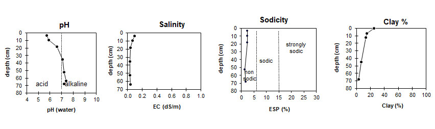
| The surface is moderately acid. The subsoil is slightly alkaline. | The salinity rating in this profile is low. | This profile in non-sodic. | The clay content is low in the surface and decreases with depth. |
Horizon | Horizon Depth (cm) | pH (water) | EC dS/m | Cl % | Organic Carbon % | Total N % | P ppm | K ppm | Exchangeable Cations | Total Bases cmolc/kg | Ex Ac cmolc/kg | CEC cmolc/kg | |||
Ca | Mg | K | Na | ||||||||||||
cmolc/kg | |||||||||||||||
A11 | 0-7 | 5.7 | 0.10 | 0.097 | 12.0 | 1.02 | 76 | 440 | 28.5 | 9.2 | 1.1 | 1.1 | 39.9 | 6.44 | 46.0 |
A12 | 7-12 | 5.9 | 0.07 | 0.071 | 5.8 | 0.61 | 46 | 220 | 22.7 | 6.9 | 0.6 | 0.8 | 31.1 | 4.24 | 35.3 |
A12 | 12-25 | 6.6 | 0.04 | 0.045 | 3.5 | 0.35 | 21 | 140 | 18.6 | 5.1 | 0.4 | 0.6 | 24.7 | 0.51 | 25.3 |
A2 | 25-45 | 7.1 | 0.03 | 0.034 | 0.9 | 0.091 | 100 | ||||||||
B21 | 45-60 | 7.2 | 0.04 | 0.042 | 0.3 | 0.033 | 5 | 100 | 5.3 | 2.3 | 0.3 | 0.1 | 8.0 | 7.4 | |
B21 | 60-68 | 7.4 | 0.04 | 0.038 | 0.5 | 0.060 | 160 | ||||||||
B22 | 68+ | 7.2 | 0.04 | 0.045 | 0.3 | 0.027 | 4 | 100 | 3.3 | 1.7 | 0.2 | 0.1 | 5.3 | 0.11 | 5.4 |
Horizon | Horizon Depth (cm) | Gravel % | Coarse Sand (0.2-2.0 mm) | Fine Sand (0.02-0.2 mm) | Silt (0.002-0.02 mm) | Clay (<0.002 mm) |
A11 | 0-7 | 6 | 50 | 8 | 25 | |
A12 | 7-12 | 8 | 61 | 7 | 15 | |
A12 | 12-25 | tr. | 2 | 72 | 6 | 13 |
A2 | 25-45 | tr. | ||||
B21 | 45-60 | 1 | 86 | 5 | 7 | |
B21 | 60-68 | |||||
B22 | 68+ | 1 | 92 | 4 | 3 |
Profile Described By: Frank Gibbons, 13th January 1965.
© State of Victoria (Agriculture Victoria) 1996 - .

This work, Victorian Resources Online, is licensed under a Creative Commons Attribution 4.0 licence. You are free to re-use the work under that licence, on the condition that you credit the State of Victoria (Agriculture Victoria) as author, indicate if changes were made and comply with the other licence terms.
The licence does not apply to ‘branding’ or some ‘images or photographs’ that may be owned by third parties. We ask you to seek prior approval to use images using the VRO feedback form. Access to higher quality images can also be provided on request.
This page was last updated on .