
OTR411
Australian Soil Classification: Humose-Mottled, Melacic, Red KANDOSOL
Northcote Factual Key: GN2.41
General Landscape Description: Mountains, Hills
Site Description: Lower Slope Slope: 5% Aspect: South
Native Vegetation: E. regnans, E. obliqua, E. gonicalyx, A. melanoxylon
Geology: Kl: Cretaceous Sediments; Felspathic Sandstone
Soil Profile Morphology:
Surface Soil
| A10 | 0-5 cm | Black (10YR2/1); loam; strong very fine crumb structure; very firm consistence, dry; pH 4.8; clear change to: | |
| A11 | 5-15 cm | Dark brown (7.5YR2/2); loam; very fine subangular blocky structure; very firm consistence, dry, pH 4.4; clear change to: | |
| A12 | 15-30 cm | Very dark greyish brown (10YR3/2), with faint yellowish brown (10YR5/4) mottles; loam; strong fine subangular blocky structure; pH 4.4; gradual change to: | |
| Subsoil | |||
| B21 | 30-60 cm | Reddish brown (5YR4/4), with many greyish brown (10YR5/2) mottles; clay; weak medium angular blocky structure; pH 4.3; diffuse change to: | |
| B22 | 60-120 cm | Reddish yellow (10YR6/6), with many greyish brown (10YR5/2) mottles; clay; weak coarse parting to fine angular blocky structure; pH 4.3; diffuse change to: | |
| B3 | 120-150 cm | Abundant mottles; sandy clay; apedal massive structure; pH 4.2 | |
Soil Profile Characteristics:
Salinity Rating | |||
Surface (A1 horizon) | Very Strongly Acid | Medium | Non Sodic |
Subsoil (B21 horizon) | Extremely Acid | Medium | Non Sodic |
Deeper Subsoil (at 120 cm) | Extremely Acid | Medium | Non Sodic |
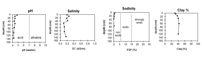
| This profile is very strongly acid at the surface, then extremely acid for the rest of the profile. | The profile has a medium salinity rating. | This profile is non-sodic. | The clay content moderate with a slow increase with depth. |
Horizon | Horizon Depth (cm) | pH (water) | EC dS/m | Cl % | Organic Carbon % | Total N % | P ppm | K ppm | Free Fe % | Exchangeable Cations | Total Bases cmolc/kg | Ex Ac cmolc/kg | CEC cmolc/kg | |||
Ca | Mg | K | Na | |||||||||||||
cmolc/kg | ||||||||||||||||
A11 | 0 - 5 | 4.8 | 0.20 | 0.029 | 8.4 | 0.61 | 21 | 380 | 2.3 | 5.1 | 5.4 | 1.3 | 0.3 | 12.1 | 21.2 | 33.3 |
A11 | 5 - 15 | 4.4 | 0.25 | 0.031 | 8.6 | 0.49 | 20 | 260 | 2.3 | 2.1 | 3.5 | 0.6 | 0.2 | 6.4 | 25.0 | 31.4 |
A12 | 15- 30 | 4.4 | 0.19 | 0.025 | 4.2 | 0.23 | 9 | 180 | 2.8 | 0.3 | 2.7 | 0.5 | 0.1 | 3.6 | 21.9 | 25.5 |
B21 | 30 - 45 | 4.3 | 0.21 | 0.029 | 2.3 | 0.13 | 5 | 180 | 3.1 | 0.2 | 1.2 | 0.5 | <0.05 | 1.9 | 18.9 | 20.8 |
45 - 60 | 4.4 | 0.10 | 0.013 | 1.0 | 0.08 | 3.9 | ||||||||||
B22 | 60 - 90 | 4.3 | 0.12 | 0.017 | 0.6 | 0.06 | 2 | 160 | 4.0 | 0.2 | 0.7 | 0.4 | <0.05 | 1.2 | 20.9 | 22.1 |
90 - 120 | 4.2 | 0.12 | 0.017 | 0.4 | 0.05 | 3.8 | ||||||||||
B3 | 120 - 150 | 4.2 | 0.17 | 0.025 | 0.3 | 0.04 | 3.7 | 0.2 | 0.6 | 0.4 | 0.1 | 1.3 | 20.1 | 21.4 | ||
Horizon | Horizon Depth (cm) | Gravel % | Coarse Sand (0.2-2.0 mm) | Fine Sand (0.02-0.2 mm) | Silt (0.002-0.02 mm) | Clay (<0.002 mm) |
A11 | 0 - 5 | 5 | 25 | 31 | 30 | |
A11 | 5 - 15 | tr | 5 | 27 | 26 | 32 |
A12 | 15- 30 | 1 | 3 | 26 | 28 | 37 |
B21 | 30 - 45 | 3 | 26 | 26 | 40 | |
45 -60 | ||||||
B22 | 60 - 90 | 5 | 27 | 23 | 42 | |
90 - 120 | ||||||
B3 | 120 - 150 | tr | 6 | 27 | 25 | 40 |
Profile Described By: Frank Gibbons, 11th January 1965.
© State of Victoria (Agriculture Victoria) 1996 - .

This work, Victorian Resources Online, is licensed under a Creative Commons Attribution 4.0 licence. You are free to re-use the work under that licence, on the condition that you credit the State of Victoria (Agriculture Victoria) as author, indicate if changes were made and comply with the other licence terms.
The licence does not apply to ‘branding’ or some ‘images or photographs’ that may be owned by third parties. We ask you to seek prior approval to use images using the VRO feedback form. Access to higher quality images can also be provided on request.
This page was last updated on .