H136
Location: Scotts Creek
Chemical Properties of Upper 10 cm:
Physical Properties of Upper 10 cm:
Profile Described By: David Rees, October 2007.
Page top
Australian Soil Classification: Self Mulching (or Epipedal) Black VERTOSOL
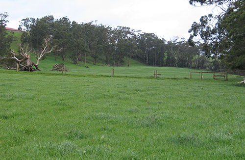
General Landscape Description: Alluvial plain/ Floodplain
Site Description: East-South Easterly facing Terrace/Flat; Gently Undulating (6%)
Vegetation: Pasture
Geology: Quaternary Sediments

Soil Profile Morphology:
Surface Soil
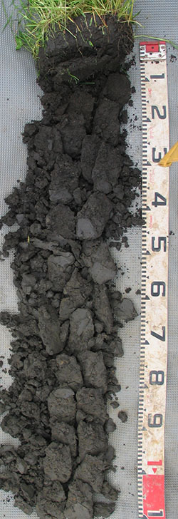
| A1 | 0-20 cm | Black (5Y2.5/1); medium clay; subangular blocky structure; rough ped fabric;weak consistence, moderately moist; pH 7.5; clear change to: |  H136 Profile H136 Profile |
| Subsoil | |||
| B21 | 20-45 cm | Black (10YR2/1); medium clay; strong fine subangular blocky structure; smooth ped fabric; firm consistence, moist; pH 7.5; clear change to: | |
| B22 | 45-80 cm | Very dark grey (2.5Y3/1); common fine faint light olive brown (2.5Y5/6) mottles; medium heavy clay; strong medium polyhedral parting to fine structure; smooth ped fabric; firm consistence, moist; pH 7.5; gradual change to: | |
| B23 | 80-100 cm | Very dark grey (2.5Y3/1) to dark grey (2.5Y4/1); common fine faint light olive brown (2.5Y5/6) mottles; heavy clay; moderate medium polyhedral parting to fine structure; smooth ped fabric; firm consistence, moist; pH 8.0. | |
Chemical Properties of Upper 10 cm:
Depth (cm) | pH (water) | pH (CaCl2) | EC dS/m | Exchangeable Cations | Total Carbon % | Total Nitrogen % | Organic Matter % | Available Aluminium mg/kg | Available Potassium (Skene K) mg/kg | Phosphorous (Olsen P) mg/kg | Available Sulphur mg/kg | Phosphorous Buffering Index | |||
Ca | Mg | K | Na | ||||||||||||
meq/100g | |||||||||||||||
0-10 | 7.0 | 6.6 | 0.24 | 29 | 3.9 | 1.1 | 0.46 | 6.5 | 0.51 | 12 | <10 | 390 | 79 | 11 | 230 |
Physical Properties of Upper 10 cm:
Depth (cm) | Bulk Density kg/L | Volumetric Water | Dispersion | Slaking | ||||||
At Saturation pF0 mL/100mL | Near Saturation pF1.0 mL/100mL | Field Capacity pF2.0 mL/100mL | Wilting Point pF4.2 mL/100mL | Dry | Remoulded | |||||
2 Hour | 20 Hour | 2 Hour | 20 Hour | |||||||
0-10 | 0.99 | 59.8 | 53.0 | 50.5 | 24.3 | Nil | Nil | Nil | Nil | Water Stable |
Profile Described By: David Rees, October 2007.


