
Rutherglen Research Institute
Back to Soil Home | Geology and Geomorphology | Rutherglen Research Institute Soil Index
| A soil survey of the then Rutherglen Research Station was carried out by T.J Poutsma and J.K.M Skene from the former Department of Agriculture. This survey was undertaken to provide more accurate soils information for the design and evaluation of soil management and fertility trials, and for the testing of plant species and varieties. About 480 hectares were examined in 1952. In 1959, a further 340 hectares were acquired and surveyed. The original area was also re-examined in more detail. The final report was then published in 1961. The soils were examined using hand-augered inspection sites from 80 to 200 metres apart and as much as 2 metres deep. Twelve profiles, representing seven soil types, were sampled for laboratory analysis. In addition, some 120 samples were collected from the surface and subsoils for information about pH and salt content across soil types. |
 |
The mapping scale used for the original map was 1:16 000 which makes this a high intensity soil survey. Twelve soil reference sites were described for the original survey and the locations of these are shown on the map in the original report. A number of soil pit sites were later described by Imhof et al (1996) and the location of these sites are marked on this clickable map. |
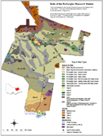
Mapping Units
Soil types differ from each other in various profile properties i.e. texture, colour and thickness of horizons. Usually these differences in soil profile are related to variations in surface features such as relief and vegetation, and the soil type can be given geographical expression e.g. the soil type can be mapped by means of these surface features.
Where different soil types are found together without any change in surface features, or where they are too closely associated to separate at the scale of working used, the soil types are mapped into complexes. Three sub-complexes or composites of soil types have also been recognised on the Station.
The soil boundary represents a zone of transition between two soil types. This zone of changing soils may cover only a few metres, or it can extend over 20 metres. This applies in a different way to the boundaries of Units 1 and 2. These often separate complexes of Rutherglen loam coupled with other soil types, from areas of pure Rutherglen loam. The boundaries here have been drawn on the irregular presence of the associate soils.
Extent of Soil Types in Poutsma and Skene (1961) Survey.
Soil Type | Area in Hectares | Percentage of Total Area |
| Soils on the Plains | ||
| Black Dog Fine Sandy Loam (including complex with Lilliput Loam). | 84 | 10 |
| Rutherglen Loam | 428 | 52 |
| Rutherglen Clay Loam and Type F | 6 | 1 |
| Types A,B,C,D | 20 | 2 |
| Unit 1 | 30 | 4 |
| Unit 2 | 132 | 16 |
| Mine Spoil | 16 | 2 |
| Creek Frontage | 2 | <1 |
| Soils on the Hill Slopes - Catena | ||
| Stillards Loam | 52 | 6 |
| Type G | 24 | 3 |
| Type H | 12 | 1 |
| Type J | 14 | 2 |
| Total | 820 | 100 |
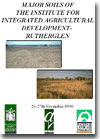
| Soil Pit Site Information In 1996, a number of soil pits were described across the Institute. These were published in an internal report by Imhof et al (1996) and used as the basis for a Soil Characterisation and Classification Workshop held at the Institute from the 26-27 November, 1996. This soil pit information is available from the clickable map above. |
 |
References
Imhof, M., Rampant, P., Lourey, R., Martin, J. and Hall, R. (1996). Major Agricultural Soils of the Institute for Integrated Agricultural Development - Rutherglen. Unpublished Report. Department of Natural Resources and Environment.
Poutsma, T.J. and Skene, J.K.M. (1961). The Soils of Rutherglen Research Station, Victoria. Technical Bulletin No. 12. Department of Agriculture.
© State of Victoria (Agriculture Victoria) 1996 - .

This work, Victorian Resources Online, is licensed under a Creative Commons Attribution 4.0 licence. You are free to re-use the work under that licence, on the condition that you credit the State of Victoria (Agriculture Victoria) as author, indicate if changes were made and comply with the other licence terms.
The licence does not apply to ‘branding’ or some ‘images or photographs’ that may be owned by third parties. We ask you to seek prior approval to use images using the VRO feedback form. Access to higher quality images can also be provided on request.
This page was last updated on .