
WP6
Location: Longeranong
Australian Soil Classification: Epicalcareous-Endohypersodic, Self-Mulching, Grey VERTOSOL
Northcote Factual Key: Ug 5.2
Great Soil Group: grey, brown and red clays
Local Soil Type Name: Kalkee Clay.
General Landscape Description: Gently Undulating Plain.
Site Description: Level plain.
Geology: Quaternary aeolian and lacustrine deposits (Woorinen Formation) overlying Tertiary deposits.
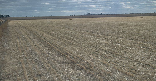 WP6 Landscape |
Soil Profile Morphology:
Surface Soil
| A11 | 0-2 cm | Greyish brown (10YR5/2); light clay; self mulching surface condition; strong fine polyhedral structure; weak to firm consistence dry; contains a few (2-5%) hard carbonate nodules (2 mm in size); pH 8.4; abrupt change to: | 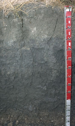 WP6 Profile |
| A12 | 2-30 cm | Dark greyish brown (10YR4/2); light medium clay (becoming heavier with depth); moderate coarse, parting to medium blocky structure; firm to very firm consistence dry; contains a few (2-5%) hard carbonate/silica nodules (2-5 mm in size) as well as very few (< 2%) iron concretions (2-5 mm in size); pH 8.3; abrupt change to: | |
| Subsoil | |||
| B21 | 30-80 cm | Dark grey (10YR4/1); heavy clay; strong coarse blocky structure; strong consistence dry; contains a few (5%) quartz fragments (1-2 mm in size); pH 8.7; gradual change to: | |
| B22 | 80-120 cm | Dark grey (10YR4/1); heavy clay; strong slickenside development; weak to firm consistence moist; contains a few (5%) quartz fragments (1-2 mm in size) as well as a few (2-5%) hard carbonate nodules (2-5 mm in size); pH 8.7; clear change to: | |
| B23k | 120-140 cm | Dark grey (10YR4/1) [with reddish yellow (7.5YR7/6) associated with carbonates]; medium heavy clay; well developed slickensides present; very firm consistence moist; contains a few (10 %) soft and hard carbonate nodules (5-10 mm in size); pH 8.8. |
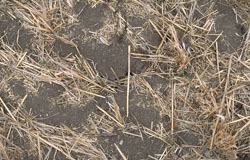
WP6 Self-mulching surface condition.
Key Profile Features:
- High clay content throughout soil profile.
- Vertic properties (ie. slickensides present) in deep subsoil.
- Self-mulching surface condition.
- Calcareous soil profile throughout.
- Variable subsoil properties related to gilgai microrelief.
Soil Profile Characteristics:
| - | pH | Salinity | ||
Surface (A11 horizon) | Moderately Alkaline | Low | Non-Sodic | None |
Subsoil (B21 horizon) | Strongly Alkaline | Low | Sodic | None 1 |
Deeper Subsoil (at 1 metre) | Strongly Alkaline | Very High | Strongly Sodic | None 2 |
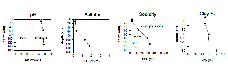
| The surface is moderately alkaline. The subsoil is strongly alkaline. | The salinity rating is low in the upper subsoil and becomes very high at 80 cm depth. | The surface is non-sodic. The subsoil is sodic becoming strongly sodic at 60 cm. |
|
Chemical and Physical Analysis:
Horizon | Horizon Depth (cm) | pH (water) | pH (CaCl2) | EC dS/m | Exchangeable Cations | |||
Ca | Mg | K | Na | |||||
meq/100g | ||||||||
A11 | 0-2 | 8.4 | 7.8 | 0.2 | 36 | 6.1 | 3.2 | 1.1 |
A12 | 2-30 | 8.3 | 7.7 | 0.19 | 41 | 4.4 | 3.5 | 1.1 |
B21 | 30-80 | 8.7 | 7.8 | 0.32 | 20 | 5.2 | 1 | 4.1 |
B22 | 80-120 | 8.7 | 8 | 1.3 | 15 | 11 | 1.3 | 11 |
B23 | 120-140 | 8.8 | 8.2 | 1.8 | 13 | 11 | 1.3 | 12 |
Horizon | Horizon Depth (cm) | Oxidisable Organic Carbon % | Total Nitrogen % | Sodium Chloride % | Wilting Point pF4.2 | Coarse Sand (0.2-2.0 mm) | Fine Sand (0.02-0.2 mm) | Silt (0.002-0.02 mm) | Clay (<0.002 mm) |
A11 | 0-2 | 1.1 | 0.13 | 23.3 | 13 | 17 | 11 | 49 | |
A12 | 2-30 | 23.1 | 16 | 20 | 8 | 47 | |||
B21 | 30-80 | 0.06 | 25.2 | 17 | 21 | 9 | 47 | ||
B22 | 80-120 | 0.25 | 27.2 | 12 | 13 | 11 | 58 | ||
B23 | 120-140 | 0.35 |
Management Considerations:
Whole Profile
- Plant available water capacity (PAWC) is considered to be relatively moderate (estimated at 105 mm). This is based on available laboratory data and assumes an effective rooting depth of 80 cm. Rooting depth will be restricted by the strongly sodic deeper subsoil and the high level of soluble salts. Few roots were evident in the soil pit profile below 80 cm depth. The availability of moisture to the plant will depend to a large degree, however, on soil structure and consistence. In dense and coarsely structured subsoils it is likely that there will be a large amount of unused ‘available’ moisture at depth in the subsoil.
- The relatively high alkalinity of the soil profile will reduce the potential of the soil to support some crops (eg. lupins).
- The surface soil is self-mulching which provides an ideal seed bed. In the dry to moist stage, these soils are friable and easy to work, but become sticky when wet. Crop establishment is promoted on friable surface soils compared to non-friable soil. Badawy (1981) notes, however, that cereal crops grown on friable clays are more prone to cereal cyst nematode.
- This soil has a high cation exchange capacity with relatively high levels of exchangeable calcium and potassium. These soils tend to mineralize nitrogen readily in cultivated bare fallows and initially produce high yields, but total nitrogen levels diminish rapidly with cropping. On similar soils in the Wimmera, legumes (including subterranean clover) often respond to additions of zinc, molybdenum, manganese, sulphur and phosphorus. Cereals respond to additions of phosphorus and zinc (Badawy 1981).
- When the soil is dry, heavy rains will move down soil cracks. This rapid recharge can be valuable for the survival of plants near wilting. When wet, the soil will swell and further infiltration will be relatively slow. After heavy rains, water can lie for long periods in the deeper gilgai depressions.
- The high wilting point value (ie. 23 %) indicates that plants will be unable to utilise light rains when the soil is relatively dry.
- Tillage of cracking clay soils should be avoided if the soil is wet (ie. wetter than the plastic limit). At such moisture conditions, excessive tillage, trafficking or over-stocking could result in structural damage (eg. compaction, smearing occurring). Ideally, tillage should take place on clay soils such as these when the soil is drier than the plastic limit, down to at least the tillage depth. [See Appendix A for information on clay compaction (page A-20) and plastic limit (page A-31)].
- The upper subsoil is sodic but does not disperse. As a result, root and water movement into the subsoil is less likely to be restricted than for other clay soils with dispersive subsoils. The relatively high levels of exchangeable calcium would contribute to reducing dispersion for this soil. The calcium to magnesium ratio is relatively high (ie. 4) for the upper subsoil horizon.
- The deeper subsoil (from 60 cm depth) becomes strongly sodic and root and water movement is likely to be restricted at depth. Some dispersion occurs in the B22 horizon.
- The high level of exchangeable sodium in the deeper subsoil may also result in nutrient imbalances and may even have a toxic effect on some plants. The levels of exchangeable magnesium also increase and the calcium to magnesium ratio is much reduced (ie. < 1.4) in the deeper subsoil.
- The salinity rating is low-medium at 30 cm depth and becomes high at 80 cm depth. This may restrict the growth of deeper rooted salt sensitive species. Under irrigation or frequent flooding, soils such as these can develop salinity problems following waterlogging of subsoils or rising watertables. In low lying areas soluble salts can accumulate at shallow depths (Badawy 1981).
- The subsoil displays strong vertic properties which indicates that significant shrinking and swelling occurs with wetting and drying cycles. This may disturb the roots of some plant species and has engineering implications (eg. disturbance to building foundations and fencelines).
- The original gilgai microrelief is caused due to the vertic properties of the soil and resultant shrinking and swelling with alternate wetting and drying. This forces ‘blocks’ of soil material gradually upward to form mounds (or ‘puffs’). The soil on the mounds will be different to soils on the depressions. Mound soils tend to be lighter in colour and have higher carbonate contents. Salinity can also often be higher in the upper soil profile on the mounds. Continuous cultivation has resulted in the smoothing out of many of these gilgai formations. However, the forces that created them are still operating, as is evident by the displacement of fence posts and if the land is left undisturbed over a number of wetting and drying seasons they will reform. In areas with gilgai microrelief, crop and pasture growth is likely to be uneven across a paddock due to soil variations and poor drainage conditions in depressions. Levelling of gilgais can reduce the depth of surface soil on gilgai mounds which may expose the subsoils.
- The strongly alkaline subsoil suggests that some nutrients (e.g. iron, manganese, zinc, copper) may be poorly available to plants and that deficiencies are likely to occur. Deficiencies should be determined by plant tissue analysis.
© State of Victoria (Agriculture Victoria) 1996 - .

This work, Victorian Resources Online, is licensed under a Creative Commons Attribution 4.0 licence. You are free to re-use the work under that licence, on the condition that you credit the State of Victoria (Agriculture Victoria) as author, indicate if changes were made and comply with the other licence terms.
The licence does not apply to ‘branding’ or some ‘images or photographs’ that may be owned by third parties. We ask you to seek prior approval to use images using the VRO feedback form. Access to higher quality images can also be provided on request.
This page was last updated on .