
WLRA124
|
| WLRA124 | 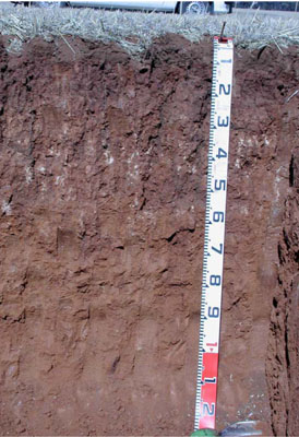 Hypercalcic, Mesonatric, Red SODOSOL | |
|
Location | Borung Highway, Areegra, western Victoria | |||
|
Landform | Crest of an undulating plain | |||
|
Geology | Quaternary Woorinen Formation: aeolian dune sand, calcareous clay | |||
|
Element | Rise crest | |||
|
Slope | 2–3% | |||
|
Aspect | South-west | |||
Horizon | Depth (cm) | Description | ||
A1 | 0–10 | Dark brown (7.5YR3/3); light sandy clay loam; weakly pedal to single grain (structureless); weak consistence when dry; pH 7.5; smooth and sharp boundary to: | ||
B21 | 10–25 | Dusky red (2.5YR3/4); medium clay; medium to coarse strong angular blocky, parting to fine to very fine subangular blocky structure; smooth ped fabric; very firm consistence when dry; very few manganiferous flecks (<2 mm) and root linings (2-6 mm), slightly calcareous, pH 8.5; clear and irregular boundary to: | ||
B22k | 25–55 | Yellowish red (5YR5/6); medium clay; medium strong prismatic, parting to fine subangular blocky structure; rough ped fabric; very firm consistence when dry; very highly calcareous with many coarse to very coarse soft calcareous segregation's; many fine pores and roots; pH 9.0; clear and irregular boundary to: | ||
B23 | 55–85 | Yellowish red (5YR5/6); light medium clay; strong fine prismatic, parting to strong very fine subangular blocky structure; rough ped fabric; very firm consistence when dry; many fine pores and roots; pH 9.0; smooth and gradual boundary to: | ||
B3 | 85–125+ | Yellowish red (5YR5/5); light medium clay; weak fine prismatic, parting to very fine subangular blocky structure; rough ped fabric; firm consistence when moderately moist; many fine pores; pH 9.0. | ||
| Management Considerations | ||||
| ||||

Horizon | Depth (cm) | pH (water) | pH (CaCl2) | EC dS/m | Exchangeable Cations cmol-/kg | Coarse Sand % | Fine Sand % | Silt % | Clay % | |||
Ca | Mg | K | Na | |||||||||
A1 | 0–10 | 7.6 | 7.1 | 0.14 | 2.7 | 1.6 | 0.24 | 2.7 | 50 | 21.6 | 5 | 19.5 |
B21 | 10–25 | 8.4 | 8 | 0.24 | 10 | 1.2 | 1.6 | 10 | 24.4 | 14.2 | 4 | 53.5 |
B22k | 25–55 | 9.3 | 8.6 | 0.33 | 12 | 1.4 | 5 | 12 | 18.1 | 15.5 | 6 | 51.5 |
B23 | 55–85 | 9.6 | 9 | 0.61 | 13 | 2 | 10 | 13 | 16.3 | 16.6 | 3.5 | 56 |
B3 | 85–125+ | 9.7 | 9 | 0.78 | 12 | 2.3 | 12 | 12 | 14.8 | 14 | 4 | 59.5 |
© State of Victoria (Agriculture Victoria) 1996 - .

This work, Victorian Resources Online, is licensed under a Creative Commons Attribution 4.0 licence. You are free to re-use the work under that licence, on the condition that you credit the State of Victoria (Agriculture Victoria) as author, indicate if changes were made and comply with the other licence terms.
The licence does not apply to ‘branding’ or some ‘images or photographs’ that may be owned by third parties. We ask you to seek prior approval to use images using the VRO feedback form. Access to higher quality images can also be provided on request.
This page was last updated on .