
WCFA3
Location: Lower Norton
Australian Soil Classification: Hypercalcic, Mottled-Subnatric, Red SODOSOL
General Landscape Description: Rise of a ridge spur.
Site Description: Lower slope of a hillslope.
Geology: Parilla Sand
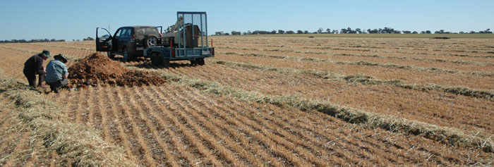
WCFA3 Landscape
Soil Profile Morphology:
| Surface Soil | 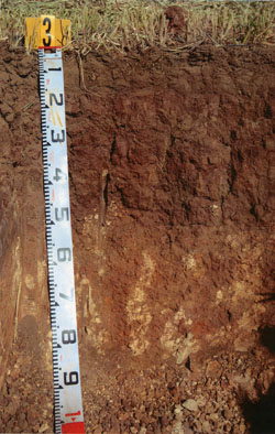 WCFA3 profile | ||
| A1 | 0-15 cm | Dark brown (7.5YR4/3); sandy loam; loose (cultivated) surface condition; weak very fine sub-angular blocky structure; rough fabric; firm consistence dry; contains a few, fine gravelly sub-rounded ferruginous fragments; pH 7.2; sharp and smooth change to: | |
| Subsoil | |||
| B21 | 15-30 cm | Red (10R4/6) with many medium distinct pale brown (10YR6/3) and yellowish brown (5YR4/6) mottles; medium heavy clay; moderate coarse prismatic, parting to moderate medium prismatic structure; smooth fabric; strong consistence dry; contains very few fine gravelly sub-rounded ferruginous fragments; pH 6.9; clear and smooth change to: | |
| B22 | 30-45 cm | Weak red (10R4/4) with common fine to medium, faint orange and grey mottles; heavy clay; moderate to strong coarse prismatic, parting to moderate to strong medium prismatic structure; smooth fabric; very strong consistence dry; contains very few fine gravelly sub-rounded ferruginous fragments; pH 7.8; clear and tongued change to: | |
| B23k | 45-90+ cm | Medium clay; strong, very coarse blocky, parting to strong medium blocky structure; smooth and rough fabric; very strong consistence dry; contains many coarse to extremely coarse calcareous segregations in patches; very highly calcareous; pH 8.7. | |
Soil Profile Characteristics:
pH | Salinity Rating | |||
Surface (A1 horizon) | Slightly Alkaline | Low | Non-Sodic | None1 |
Subsoil (B21 horizon) | Slightly Acid | Low | Sodic | None2 |
Deeper Subsoil (at 55-100 cm) | Strongly Alkaline | Medium | Sodic | None |
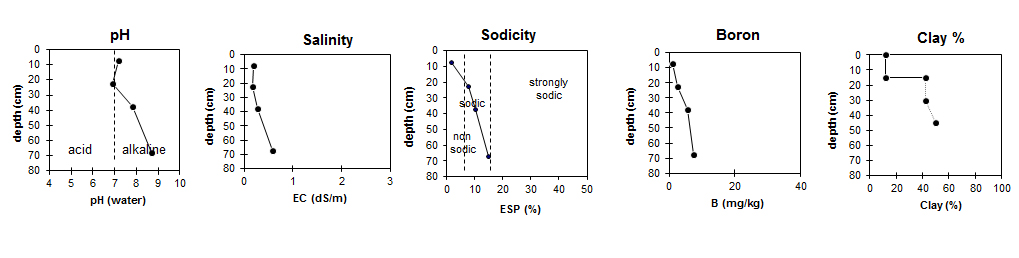
| The salinity rating in the upper profile is low becoming medium at depth.
| The surface is non-sodic. The subsoil is sodic. | Boron content increases with depth. |
|
Horizon | Horizon Depth (cm) | pH (water) | pH (CaCl2) | EC dS/m | NaCl % | Exchangeable Cations | |||
Ca | Mg | K | Na | ||||||
meq/100g | |||||||||
A1 | 0-15 | 7.2 | 6.9 | 0.2 | - | 8.3 | 0.95 | 1.1 | 0.17 |
B21 | 15-30 | 6.9 | 6.4 | 0.18 | - | 9.2 | 6.6 | 0.88 | 1.4 |
B22 | 30-45 | 7.8 | 7.2 | 0.28 | <0.02 | 14 | 14 | 1.1 | 3.3 |
B23k | 45-90 | 8.7 | 8.3 | 0.58 | 0.04 | 8.6 | 12 | 0.76 | 3.7 |
Horizon | Horizon Depth (cm) | Oxidisable Organic Carbon % | Total Nitrogen % | Available Boron mg/kg | Field Capacity pF2.5 | Wilting Point pF4.2 | Coarse Sand (0.2-2.0 mm) | Fine Sand (0.02-0.2 mm) | Silt (0.002-0.02 mm) | Clay (<0.002 mm) |
A1 | 0-15 | 1.5 | 0.1 | 1 | 13.8 | 4.8 | 15 | 64 | 6 | 12 |
B21 | 15-30 | 2.5 | 26.4 | 15.4 | 11 | 38 | 5 | 42 | ||
B22 | 30-45 | 5.5 | 38.5 | 23.7 | ||||||
B23k | 45-90 | 7.4 | 31.7 | 16.9 |
Profile Described By: Nathan Robinson, Grant Boyle and John Martin (October 2006).
© State of Victoria (Agriculture Victoria) 1996 - .

This work, Victorian Resources Online, is licensed under a Creative Commons Attribution 4.0 licence. You are free to re-use the work under that licence, on the condition that you credit the State of Victoria (Agriculture Victoria) as author, indicate if changes were made and comply with the other licence terms.
The licence does not apply to ‘branding’ or some ‘images or photographs’ that may be owned by third parties. We ask you to seek prior approval to use images using the VRO feedback form. Access to higher quality images can also be provided on request.
This page was last updated on .