
LSWW17
|
| LSWW17 | 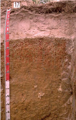 Calcic, Mottled_mesonatric, Yellow SODOSOL | |
|
Location | North-east of Langkoop, western Victoria | |||
|
Landform | Plain | |||
|
Geology | Quaternary swamp and lake deposits: paludal silt and clay | |||
|
Element | Plain | |||
Horizon | Depth (cm) | Description | ||
A1 | 0–15 | Brown (7.5YR4/2); loamy sand; weakly structured to massive (structureless); very weak consistence when dry; very few ferruginous nodules; pH 6.9; clear boundary to: | ||
A21 | 15–40 | Light brown (7.5YR6/4), conspicuously bleached; sand; massive (structureless); a few ferruginous nodules; pH 5.7; clear boundary to: | ||
A22 | 40–47 | Pink (7.5YR7/4), conspicuously bleached; sand; massive (structureless); very weak consistence when dry; a few (10-20%) ferruginous nodules (some areas there is a larger percentage of nodules); pH 6.1; sharp boundary to: | ||
B21 | 47–85 | Yellow (10YR7/8) with very coarse distinct dark red and light grey mottles; light clay grading to light medium clay at depth; some organic staining on ped faces; strong medium to coarse, parting to strong coarse blocky structure; abundant yellowish brown clay skin cutans; strong consistence when dry (complete dispersion when worked); pH 6.3: | ||
B22 | 85–135 | Brownish yellow (10YR6/6); medium heavy clay (sandy); moderate very coarse prismatic structure; very firm consistence when slightly moist; few (2%) soft calcareous segregations and hard calcareous/silica nodules; complete dispersion; pH 9.0: | ||
B23 | 135–190 | Pale yellow (2.5Y7/4) with a few patches of light grey mottles; medium clay; moderate very coarse prismatic, parting to strong coarse blocky, parting to moderate coarse polyhedral structure; few manganese flecks and ferruginous nodules; pH 9.2. | ||
| Management Considerations | ||||
| ||||
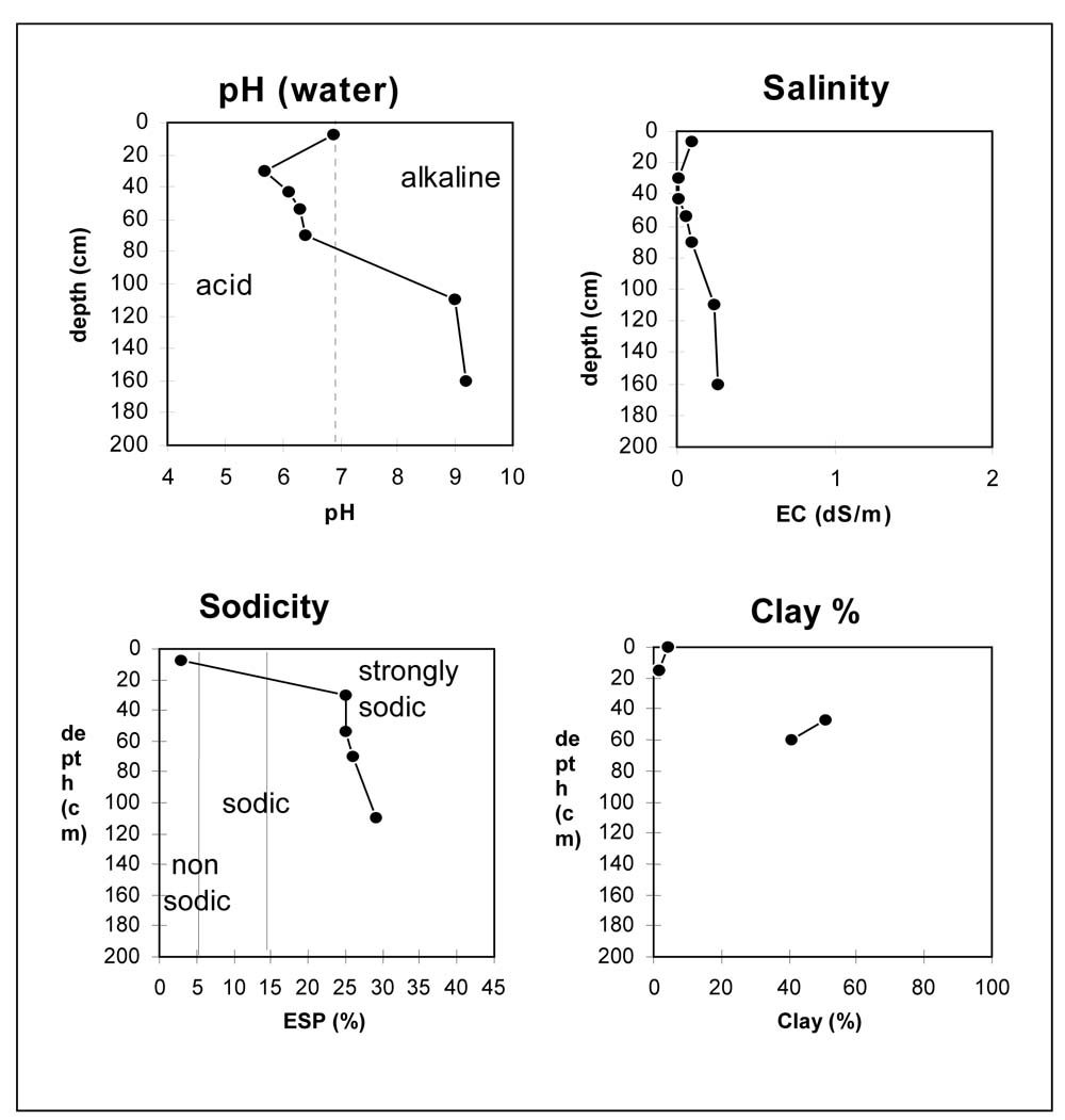
Horizon | Depth (cm) | pH (water) | pH (CaCl2) | EC dS/m | Exchangeable Cations cmol-/kg | Wilting Point (pF4.2) | Coarse Sand % | Fine Sand % | Silt % | Clay % | |||
Ca | Mg | K | Na | ||||||||||
A1 | 0–15 | 6.9 | 6.5 | 0.1 | 3.1 | 0.4 | 0.1 | 0.1 | 4.7 | 41.2 | 47.8 | 2 | 4 |
A21 | 15–40 | 5.7 | 4.9 | <0.05 | 0.1 | <0.1 | <0.1 | <0.1 | 1.0 | 39.9 | 54.1 | 2.5 | 1.5 |
A22 | 40–47 | 6.1 | 5 | <0.05 | |||||||||
B21 | 47–60 | 6.3 | 4.7 | 0.06 | 2.6 | 4.5 | 0.2 | 2.4 | 19.0 | 18.3 | 23.2 | 1.5 | 51 |
B21 | 60–85 | 6.4 | 5 | 0.1 | 2.4 | 5.2 | 0.2 | 2.7 | 14.9 | 25.2 | 28.3 | 1.5 | 40.5 |
B22 | 85–135 | 9 | 8 | 0.24 | 3.3 | 6.8 | 0.2 | 4.1 | |||||
B23 | 135–190 | 9.2 | 8.3 | 0.26 | |||||||||
| Site: LSWW17 | Land Unit: Red Gum Plains and Rises |
| Aust. Soil Class.: Calcic, Mottled-Mesonatric, Yellow SODOSOL (confidence level 1) | |
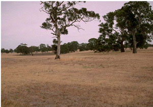
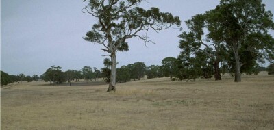 | General Land Unit Description: This land unit comprises the Quaternary lacustrine geology mainly north of the Glenelg River and around Balmoral. The landscape is generally gently undulating plains dissected with small clay plains. The soils in this land unit are similar to many of the soils in the study area – a strong textural contrast between the light textured topsoil and the sodic clay subsoil (Sodosol). The distinguishing feature of the soil type is the presence of an uncemented gravel (ironstone) above the clay, consisting mainly of ferruginised iron nodules mixed with indurated sandstone and manganese nodules. The presence of the bleached horizon (A2) and the mottles in the subsoil indicates impeded internal soil drainage. The presence of manganese flecks and nodules in some of the profiles may indicate the presence of a seasonally perched watertable. The subsoil is often sodic, and is also often strongly dispersive, destroying the structure of the subsoil and resulting in an evident large columnar or prismatic structure. Although often there can be secondary cracks in the large prisms or columns, it remains difficult for plant roots to penetrate deep into the subsoil. The dominant tree species located on this land unit is red gum. |
Site Description:
| Slope: 1-3% | Geology: Quaternary lacustrine |
| Landform pattern: Gently to undulating plain | Position in landscape: Mid slope |
| Internal drainage: Imperfectly drained |
| A1 | 0-15 cm | Brown (7.5YR4/2) loamy sand, weakly structured to structureless, very weak consistence when dry, very few ferruginised iron nodules. pH 6.9. Clear transition to: | 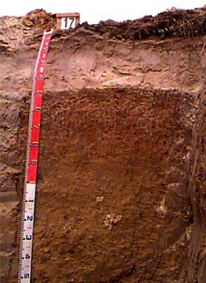 |
| A21 | 15-40 cm | Light brown (7.5YR6/4) sand, conspicuously bleached when dry, structureless, a few (5-10%) ferruginised iron nodules. pH 5.7. Clear transition to: | |
| A22 | 40-47 cm | Pink (7.5YR7/4) sand, conspicuously bleached when dry, structureless, very weak consistence when dry, a few (10-20%) ferruginised iron nodules (some areas there is a larger percentage of nodules). pH 6.1. Sharp transition to: | |
| Subsoil | |||
| B21 | 47-85 cm | Yellow (10YR7/8) light clay grading to light medium clay at depth, very coarse distinct dark red and light grey mottles and yellowish brown clay skins are abundant, some organic staining down ped faces, strong prismatic structure (peds 20-100 mm), breaking to strong blocky structure, (peds 20-50 mm), strong consistence when dry, complete dispersion when worked. pH6.3. | |
| B22 | 85-135 cm | Brownish yellow (10YR6/6) medium heavy clay (sandy) moderate prismatic structure, (peds >200 mm), very firm consistence when slightly moist, a few (2%) soft calcium carbonate segregations and hard carbonate/silica nodules, complete dispersion. pH 9.0. | |
| B23 | 135-190 cm | Pale yellow (2.5Y7/4) medium clay with a few patches of light grey mottles, moderate prismatic structure, (peds >200 mm), breaking to strong blocky structure, (peds 20-50 mm), breaking to moderate polyhedral structure, (peds, 20-50 mm), a few (2%) manganese flecks and ferruginised iron nodules. pH 9.2. |
Key Profile Features
- Sandy topsoil
- Strong texture contrast between topsoil and subsoil
- Bleached A2 horizon
- Sodic subsoil
- Mottled subsoil
- Top of the subsoil is dispersive following cultivation when wet
- Ferruginous pan
- Slightly acidic A21 horizon
- Top of the subsoil slightly acidic
- Alkaline subsoil at depth (>85 cm)
- Organic staining down faces and clay skins of the B21 indicates that there is some shrinking and swelling of the soil
© State of Victoria (Agriculture Victoria) 1996 - .

This work, Victorian Resources Online, is licensed under a Creative Commons Attribution 4.0 licence. You are free to re-use the work under that licence, on the condition that you credit the State of Victoria (Agriculture Victoria) as author, indicate if changes were made and comply with the other licence terms.
The licence does not apply to ‘branding’ or some ‘images or photographs’ that may be owned by third parties. We ask you to seek prior approval to use images using the VRO feedback form. Access to higher quality images can also be provided on request.
This page was last updated on .