
LSWW14
|
| LSWW14 | 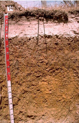 Vertic, Mottled-Mesonatric, Grey Sodosol | |
|
Location | North-west of Lake Wallace, Edenhope, western Victoria | |||
|
Landform | Plain | |||
|
Geology | Quaternary Lowan Formation: aeolian fine to medium grained dune sand | |||
|
Element | Plain | |||
Horizon | Depth (cm) | Description | ||
A1 | 0–10 | Very dark greyish brown (10YR3/2); sand (organic); weak consistence when dry; pH 5.8; abrupt boundary to: | ||
A2 | 10–35 | Pink (7.5YR7/4); conspicuously bleached sand;; massive (structureless); weak consistence when dry; few subrounded ferruginous nodules; pH 6.5; thin (2-5 mm) capping directly above the clay with a very strong consistence when dry; sharp boundary to: | ||
B21 | 35–70 | Pale brown (10YR6/3) changing at depth to yellowish brown (10YR5/6) with abundant coarse distinct red, light grey and yellowish brown mottles; medium clay; moderate coarse blocky, parting to moderate medium polyhedral structure and in patches strong fine polyhedral structure; strong consistence when dry (dispersive when worked); pH 6.4; clear boundary to: | ||
B22 | 70–120 | Yellowish brown (10YR5/6); medium clay; dark stains on prism faces; moderate to strong coarse prismatic, parting to moderate coarse blocky structure; strong consistence when slightly moist; pockets of clayey sand; pH 8.2; gradual boundary to: | ||
B23 | 120–150 | Yellow (10YR7/8); medium clay; strong lenticular structure in patches; firm to very firm consistence when moderately moist; pH 8.8; gradual boundary to: | ||
B31 | 150–170 | Brownish yellow (10YR6/6); sandy clay (with patches of grey); firm consistence when moderately moist; pH 8.6; gradual boundary to: | ||
B32 | 170–200+ | Pinkish grey (7.5YR6/2); sandy clay loam; veins of bluish grey (5B6/1) clay and red flecks of quartz sand; firm consistence when moderately moist; pH 8.7. | ||
| Management considerations | ||||
| ||||
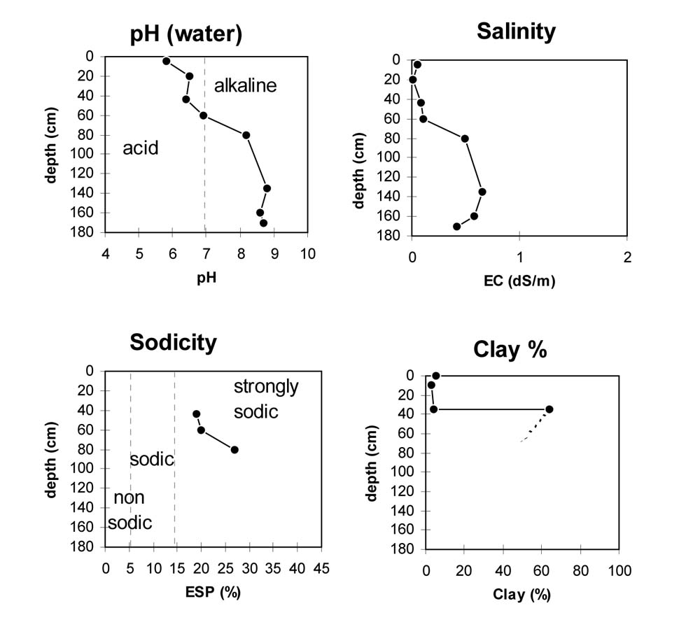
Site WW14 | Sample depth cm | pH | EC dS/m | NaCl % | Ex Ca cmol-/kg | Ex Mg cmol-/kg | Ex K cmol-/kg | Ex Na cmol-/kg | Ex Al mg/kg | Ex acidity cmol-/kg | FC -30okPa | PWP -1500okPa | KS % | FS % | Z % | C % | |
Horizon | H2O | CaCl2 | |||||||||||||||
A1 | 0–10 | 5.8 | 5.1 | 0.05 | NA | 1.7 | 0.4 | 0.1 | 0.1 | NA | NA | NA | 6.1 | 53.6 | 31.1 | 4 | 5.5 |
A2 | 10–35 | 6.5 | 5.8 | <0.05 | NA | <0.1 | <0.1 | <0.1 | <0.1 | NA | NA | NA | 0.9 | 48.9 | 42.6 | 2.5 | 3 |
B21 | 35–70 | 6.4 | 5.3 | 0.09 | NA | 2.7 | 7.3 | 0.4 | 2.4 | NA | NA | NA | 23.9 | 15.2 | 12 | 2 | 64 |
B22 | 70–120 | 6.9 | 5.8 | 0.11 | NA | 2.5 | 7.2 | 0.3 | 2.5 | NA | NA | NA | 18.1 | 23.6 | 20.2 | 2 | 49.5 |
B22 | 70–120 | 8.2 | 7.6 | 0.49 | 0.11 | 2.8 | 9.4 | 0.3 | 4.6 | NA | NA | NA | NA | NA | NA | NA | NA |
B23 | 120–150 | 8.6 | 7.6 | 0.32 | 0.08 | NA | NA | NA | NA | NA | NA | NA | NA | NA | NA | NA | NA |
B31 | 150–170 | 8.8 | 8.1 | 0.66 | 0.13 | NA | NA | NA | NA | NA | NA | NA | NA | NA | NA | NA | NA |
B32 | 170–200+ | 8.6 | 7.8 | 0.58 | 0.11 | NA | NA | NA | NA | NA | NA | NA | NA | NA | NA | NA | NA |
| Site: LSWW14 | Land Unit: Sand Plains and Rises |
| Aust. Soil Class.: Vertic, Mottled-Mesonatric, Grey SODOSOL(confidence level 1) | |
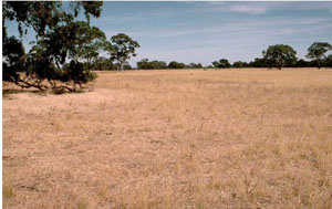
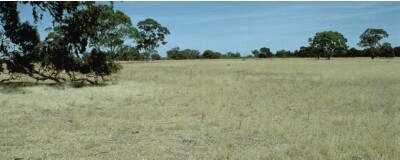 | General Land Unit Description: This land unit comprises areas with reasonably deep sand deposits, mainly north of the Kanawinka fault. The vegetation commonly marks the distinct changes from a landscape comprising of deep sand to one of shallow sand. The major tree species on the deep sand is Brown Stringybark, with an understorey of heath vegetation, such as Blackboys and Tea Trees. Yellow Gums prefer the shallower sandy topsoils. The major landform in this land unit is gently undulating plains where there are gentle rises and low dunes. The common soil type on the gentle rises and low dunes is a sandy topsoil over mottled clay. The depth of sand is variable (often deeper than 50 cm) similar to this site, and can be as deep as two metres in some areas. The subsoils can be strongly acidic (Kurosol), although Chromosols and Sodosols also occur. Ferruginous nodules above the clay horizon are common. There are minor areas where dunes are the dominant landform. Podosols, Tenosols and soils with a deep sandy topsoil over a clay subsoil occur on the steeper dunes and Chromosols or Kurosols occur on the gentler dunes, with Sodosols and Vertosols on the swales and drainage depression. Podosols are soil types with a deep sandy profile that have a ‘coffee rock’ layer commonly at depth. This site is found close to areas of deeper sand and shows the soil type on the transition away from the deep sandy soils. The crests and upper slopes above this unit commonly have deep sands (often greater than 1.5 metres on the crests). Dry heath vegetation associated with this land unit, such as Stringbarks, Blackboys, and Tea Trees, are indicative of the deeper sands. |
Site Description:
| Geology: Quaternary aeolian | Landform pattern: Gently undulating plain |
| Position in landscape: Lower slope | Internal drainage: Imperfectly drained |
| A1 | 0-10 cm | Very dark greyish brown (10YR3/2) sand (organic); weak consistence when dry. pH 5.8. Abrupt transition to: | 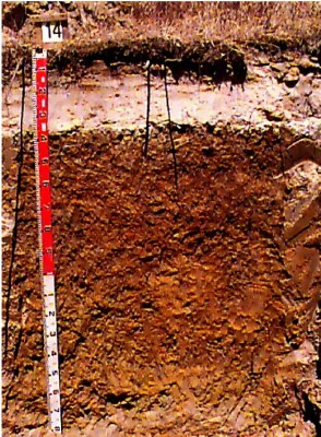 |
| A2 | 10-35 cm | Pink (7.5YR7/4) sand; conspicuously bleached sand, structureless, weak consistence when dry. A few subrounded ferruginised iron-stone gravels. pH 6.5. Thin (2-5mm) capping directly above the clay, with a very strong consistence when dry. Sharp transition to: | |
| Subsoil | |||
| B21 | 35-70 cm | Pale brown (10YR6/3) changing at depth to yellowish brown (10YR5/6) medium clay; coarse distinct red, light grey and yellowish brown mottles are abundant, moderate blocky structure, (peds 20-50 mm), breaking to moderate polyhedral structure (peds 10-20 mm) and in patches strong polyhedral structure, (peds 5-10 mm), strong consistence when dry. pH 6.4. Dispersive when worked. Clear transition to: | |
| B22 | 70-120 cm | Yellowish brown (10YR5/6) medium clay; with dark stains down prism faces, moderate to strong prismatic structure (peds 50-100 mm), breaking to moderate blocky structure (peds 20-50 mm); strong consistence when slightly moist. Pockets of clayey sand. pH 8.2. Gradual transition to: | |
| B23 | 120-150 cm | Yellow (10YR7/8) medium clay; strong lenticular structure in patches, firm to very firm consistence when moderately moist. pH 8.8. Gradual transition to: | |
| B31 | 150-170 cm | Brownish yellow (10YR6/6) sandy clay (with patches of grey); firm consistence when moderately moist. pH 8.6. Gradual transition to: | |
| B32 | 170-200+ cm | Pinkish grey (7.5YR6/2) sandy clay loam; veins of bluish grey (5B6/1) clay, and red flecks of quartz sand, firm consistence when moderately moist. pH 8.7. |
Key Profile Features
- Sandy topsoil
- Hyrophobic topsoil
- Strong texture contrast between topsoil and subsoil
- Bleached A2 horizon
- Sodic subsoil
- Mottled subsoil
- Subsoil disperses following cultivation when wet
- Acidic topsoil
- Alkaline subsoil at depth
- Cracking deeper subsoils
© State of Victoria (Agriculture Victoria) 1996 - .

This work, Victorian Resources Online, is licensed under a Creative Commons Attribution 4.0 licence. You are free to re-use the work under that licence, on the condition that you credit the State of Victoria (Agriculture Victoria) as author, indicate if changes were made and comply with the other licence terms.
The licence does not apply to ‘branding’ or some ‘images or photographs’ that may be owned by third parties. We ask you to seek prior approval to use images using the VRO feedback form. Access to higher quality images can also be provided on request.
This page was last updated on .