
LSWW11
|
| LSWW11 | 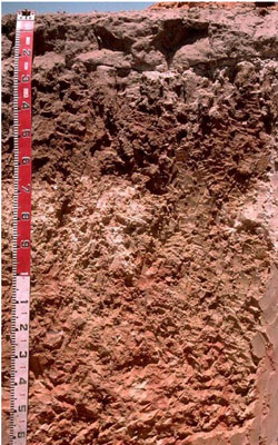 Hypercalcic, Mottled-Hypernatric, Brown SODOSOL | |
|
Location | West of Booroopki Swamp, western Victoria | |||
|
Landform | Rise | |||
|
Geology | Quaternary Woorinen Formation: aeolian dune sand, calcareous clay | |||
|
Element | Hillcrest | |||
Horizon | Depth (cm) | Description | ||
A1 | 0–20 | Dark brown (10YR3/3); loamy sand; massive (structureless); weak consistence when dry; pH 6.1. | ||
A2 | 20–25 | Pale brown (10YR6/3); loamy sand; conspicuously bleached; massive (structureless); weak consistence when dry; discontinuous horizon; pH 6.9; sharp boundary to: | ||
B21 | 25–65 | Brown (10YR4/3) with many coarse distinct yellowish brown and red mottles, colour changes to strong brown (7.5YR5/6) at depth and mottle abundance decreases; medium heavy clay; strong very coarse columnar, parting to moderate very coarse blocky structure; very strong consistence when dry (complete dispersion); pH 7.5. | ||
B22k | 65–100 | Pink (7.5YR7/4) with common fine distinct reddish yellow mottles; medium clay, fine sandy; moderate coarse prismatic, parting to coarse blocky structure; many (40%) soft calcareous segregations, and a few (5%) hard silica/carbonate nodules; strong dispersion; horizon is discontinuous, with the carbonate forming large patches in places; pH 9.6. | ||
B23 | 100–130 | Reddish yellow (7.5YR7/6) with common yellowish red mottles; medium clay, coarse sandy; pH 9.7. | ||
BC | 130–180+ | Partially weathered sandstone; pH 9.5.
| ||
| Management Considerations | ||||
| ||||
Horizon | Depth (cm) | pH (water) | pH (CaCl2) | EC dS/m | NaCl % | Exchangeable Cations cmol-/kg | Wilting Point (pF 4.2) | Coarse Sand % | Fine Sand % | Silt % | Clay % | |||
Ca | Mg | K | Na | |||||||||||
A1 | 0–20 | 6.1 | 5.6 | 0.12 | 2.5 | 0.9 | 0.3 | 0.3 | 8.5 | 42.2 | 38.2 | 4.5 | 8 | |
A2 | 20–25 | 6.9 | 6.4 | <0.05 | ||||||||||
B21 | 25–65 | 7.5 | 6.6 | 0.25 | 4.1 | 8.1 | 0.4 | 4.7 | 19.4 | 27.4 | 22.4 | 3.5 | 40.5 | |
B22k | 65–100 | 9.6 | 9.0 | 0.53 | <0.05 | 3.8 | 12 | 0.5 | 7.3 | 16.7 | 31.5 | 23.2 | 3 | 35 |
B22k | 65–100 | 9.8 | 8.7 | 0.49 | <0.05 | |||||||||
B23 | 100–130 | 9.7 | 9.0 | 0.52 | <0.05 | |||||||||
BC | 130–180+ | 9.5 | 8.6 | 0.29 | ||||||||||
© State of Victoria (Agriculture Victoria) 1996 - .

This work, Victorian Resources Online, is licensed under a Creative Commons Attribution 4.0 licence. You are free to re-use the work under that licence, on the condition that you credit the State of Victoria (Agriculture Victoria) as author, indicate if changes were made and comply with the other licence terms.
The licence does not apply to ‘branding’ or some ‘images or photographs’ that may be owned by third parties. We ask you to seek prior approval to use images using the VRO feedback form. Access to higher quality images can also be provided on request.
This page was last updated on .