
LSWW07
| 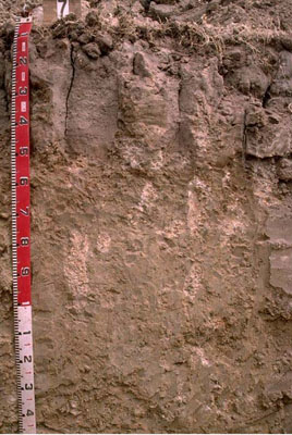 Hypercalcic, Mottled-Subnatric, Grey SODOSOL | |||
|
Location | Kaniva South Road, Lillimur South, western Victoria | |||
|
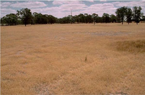
Landform | Plain | |||
|
Geology | Quaternary Lowan Formation: aeolian fine to medium grained dune sand | |||
|
Element | Plain | |||
Horizon | Depth (cm) | Description | ||
A1 | 0–10 | Very dark greyish brown (10YR3/2); light fine sandy loam; pH 6.1: | ||
A2 | 10–12 | Conspicuously bleached hard setting sand that tends to occur in patches, as domed capping on top of columnar subsoil structure: | ||
B21 | 12–30 | Light greyish brown (10YR6/2) with a few faint brownish yellow mottles; medium clay (sandy); strong very coarse columnar structure; very strong consistence when dry (completely dispersive); pH 8.6: | ||
B22 | 30–50 | Very pale brown (10YR7/3) with a few faint yellow mottles; medium clay (sandy); strong very coarse columnar structure; strongly dispersive; pH9.3: | ||
B23 | 50–100 | Very pale brown (10YR7/3) with yellow and reddish yellow mottles; medium clay (sandy); many soft calcareous segregations and very few hard calcareous nodules; completely dispersive; pH 10: | ||
B24 | 100–190+ | Light grey (5Y7/2); medium clay (sandy); moderate coarse polyhedral structure; smooth ped-fabric; few soft and hard calcareous segregations; manganese flecks occur at depth; pH 9.9. | ||
| Management Considerations | ||||
| ||||
Horizon | Depth (cm) | pH (water) | pH (CaCl2) | EC dS/m | NaCl % | Exchangeable Cations cmol-/kg | Wilting Point (pF4.2) | Coarse Sand % | Fine Sand % | Silt % | Clay % | |||
Ca | Mg | K | Na | |||||||||||
A1 | 0–10 | 6.1 | 5.1 | 0.09 | 2.4 | 1.7 | 0.5 | 0.5 | 8.4 | 26.1 | 48.4 | 3.5 | 15 | |
A2 | 10–12 | 15.3 | ||||||||||||
B21 | 12–30 | 8.6 | 7.7 | 0.16 | 6.7 | 6.9 | 1.3 | 1.9 | 15.5 | 20.5 | 37.6 | 3 | 34 | |
B22 | 30–50 | 9.3 | 8.4 | 0.22 | 7.4 | 7.5 | 1.3 | 2.4 | 23.4 | 36.8 | 2 | 30.5 | ||
B23 | 50–100 | 10 | 9 | 0.52 | 1.5 | 8.4 | 1.1 | 7.1 | ||||||
B24 | 100–190+ | 9.9 | 9 | 0.47 | <0.05 | |||||||||
© State of Victoria (Agriculture Victoria) 1996 - .

This work, Victorian Resources Online, is licensed under a Creative Commons Attribution 4.0 licence. You are free to re-use the work under that licence, on the condition that you credit the State of Victoria (Agriculture Victoria) as author, indicate if changes were made and comply with the other licence terms.
The licence does not apply to ‘branding’ or some ‘images or photographs’ that may be owned by third parties. We ask you to seek prior approval to use images using the VRO feedback form. Access to higher quality images can also be provided on request.
This page was last updated on .