
LSWW05
| 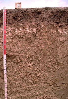 Endocalcareous-Endohypersodic, Self-mulching Brown VERTOSOL | |||
|
Location | Lillimur, western Victoria | |||
|
Landform | Rise | |||
|
Geology | Quaternary Woorinen Formation: aeolian dune sand, calcareous clay | |||
|
Element | Hillslope | |||
Horizon | Depth (cm) | Description | ||
A1 | 0–10 | Dark greyish brown (10YR4/2); light medium clay; moderate coarse blocky structure, parting to moderate fine polyhedral structure; self-mulching surface condition; firm consistence when dry; pH 8.2: | ||
B21 | 10–30 | Dark brown (7.5YR4/4); light medium clay; strong medium polyhedral, parting to fine and very fine polyhedral structure; strong consistence when slightly moist; pH 8.6: | ||
B22 | 30–45 | Dark brown (7.5YR4/4); medium heavy clay; strong coarse blocky structure; very strong consistence when dry (complete dispersion when worked); pH 9.1: | ||
B23 | 45–60 | Reddish yellow (7.5YR7/6); medium heavy clay; strong coarse blocky structure; strong consistence when slightly moist; common soft calcareous segregations; pH 9.5: | ||
B24 | 60–90 | Light yellowish brown (10YR6/4); light medium clay; weak to moderate medium prismatic structure; very firm consistence when slightly moist; very few calcareous and silica nodules; pH 9.1: | ||
B25 | 90–180+ | Pale yellow (2.5Y7/4); medium clay; strong coarse polyhedral structure; firm consistence when slightly moist; very few manganese flecks; few calcareous and silica nodules (2–20 mm); slickensides occur with many large slickensides occurring below 140 cm; pH 9.1. | ||
| Management Considerations | ||||
| ||||
Horizon | Depth (cm) | pH (water) | pH (CaCl2) | EC dS/m | NaCl % | Exchangeable Cations cmol-/kg | Wilting Point | Coarse Sand % | Fine Sand % | Silt % | Clay % | |||
Ca | Mg | K | Na | |||||||||||
A1 | 0–10 | 8.2 | 7.7 | 0.13 | 27 | 4.1 | 2 | 0.3 | 23.4 | 8 | 22.8 | 8.5 | 48.5 | |
B21 | 10–30 | 8.6 | 7.8 | 0.16 | 22 | 8.1 | 1.2 | 1.7 | 26.3 | 7.2 | 22.6 | 7.5 | 53 | |
B22 | 30–45 | 9.1 | 8.2 | 0.24 | 17 | 12 | 1.2 | 4.8 | 29.2 | 7.4 | 21.7 | 7 | 54 | |
B23 | 45–60 | 9.5 | 8.5 | 0.42 | <0.05 | |||||||||
B24 | 60–90 | 9.1 | 8.4 | 0.93 | 0.05 | 15 | 8.4 | 1.2 | 8.1 | |||||
B25 | 90–180+ | 9.1 | 8.6 | 1.3 | 0.09 | 8.3 | 11 | 1.2 | 10 | |||||
© State of Victoria (Agriculture Victoria) 1996 - .

This work, Victorian Resources Online, is licensed under a Creative Commons Attribution 4.0 licence. You are free to re-use the work under that licence, on the condition that you credit the State of Victoria (Agriculture Victoria) as author, indicate if changes were made and comply with the other licence terms.
The licence does not apply to ‘branding’ or some ‘images or photographs’ that may be owned by third parties. We ask you to seek prior approval to use images using the VRO feedback form. Access to higher quality images can also be provided on request.
This page was last updated on .