
LS22
Location: Perenna
Australian Soil Classification: Epibasic, Pedal, Hypercalcic, CALCAROSOL
General Landscape Description: Gently undulating plain.
Site Description: Crest of a continuously cropped paddock.
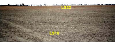 |
| LS22 Landscape |
Soil Profile Morphology:
Surface Soil
| A11 | 0-10 cm | Dark reddish brown (5YR3/3); loamy sand; massive; weak consistence dry; pH 8.1; clear change to: | 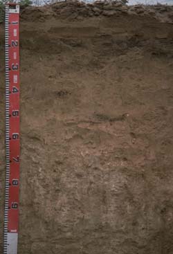 LS22 Profile |
| A12 | 10-18 cm | Dark reddish brown (5YR3/4); loamy sand; massive (plough pan effect); firm consistence moist; sharp change to: | |
| A13 | 18-25 cm | Dark reddish brown (5YR3/3); clay loam; massive; weak consistence dry; highly calcareous; roots stop here; pH 8.6; sharp change to: | |
| Subsoil | |||
| B1 | 25-50 cm | Reddish yellow (5YR6/5); fine sandy clay loam; weak medium subangular blocky structure; weak consistence moist; very few hard carbonate nodules present; highly calcareous; pH 8.7; gradual change to: | |
| B21 | 50-100 cm | Pinkish grey (7.5YR6/2), with yellowish red (5YR5/6) infills; light medium clay; moderate medium blocky structure; weak consistence moist; contains many soft carbonate and hard silica carbonate segregations; very highly calcareous; pH 9.4. |
Soil Profile Characteristics:
pH | Salinity | |||
Surface (A1 horizon) | Moderately Alkaline | Low | Non-Sodic | - |
Subsoil (B21 horizon) | Strongly Alkaline | Low | Non-Sodic | None |
Deeper Subsoil (60-110 cm) | Very Strongly Alkaline | Low | Sodic | None1 |
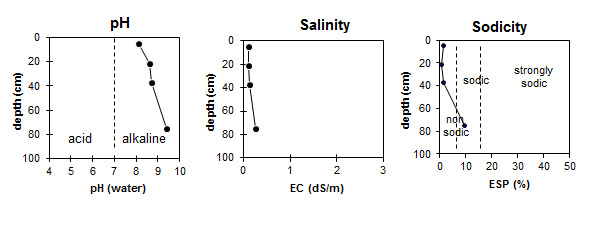
| The surface horizon is moderately alkaline. The upper subsoil is strongly alkaline becoming very strongly alkaline with depth. | The salinity rating for this profile is low throughout. | The surface and upper subsoil is non-sodic. The deeper subsoil is sodic. |
Chemical and Physical Analysis:
Horizon | Horizon Depth (cm) | pH (water) | pH (CaCl2) | EC dS/m | Na Cl % | Exchangeable Cations | Total Nitrogen % | Organic Carbon % | Field Capacity pF 2.5 | Wilting Point pF 4.2 | Coarse Sand (0.2 - 2 mm) | Fine Sand (0.02-0.2 mm) | Silt (0.002-0.02 mm) | Clay (<0.002 mm) | |||
Ca | Mg | K | Na | ||||||||||||||
meq/100g | |||||||||||||||||
A11 | 0-10 | 8.1 | 7.4 | 0.1 | <0.05 | 4.2 | 1.3 | 0.9 | 0.1 | <0.05 | 0.24 | 7.5 | 4.2 | ||||
A12 | 10-18 | ||||||||||||||||
A13 | 18-25 | 8.6 | 7.8 | 0.1 | 14.1 | 2.5 | 1.6 | 0.1 | 24 | 35 | 2 | 31 | |||||
B1 | 25-50 | 8.7 | 8.0 | 0.13 | 15 | 5.2 | 1.7 | 0.3 | 30.1 | 18.7 | 20 | 27 | 1 | 36 | |||
B21 | 50-100 | 9.4 | 8.4 | 0.27 | 6.1 | 14 | 2.4 | 2.3 | 40.1 | 26.6 | |||||||
Profile Described By: Mark Imhof, David Rees, Sonia Thompson (May 1994).
© State of Victoria (Agriculture Victoria) 1996 - .

This work, Victorian Resources Online, is licensed under a Creative Commons Attribution 4.0 licence. You are free to re-use the work under that licence, on the condition that you credit the State of Victoria (Agriculture Victoria) as author, indicate if changes were made and comply with the other licence terms.
The licence does not apply to ‘branding’ or some ‘images or photographs’ that may be owned by third parties. We ask you to seek prior approval to use images using the VRO feedback form. Access to higher quality images can also be provided on request.
This page was last updated on .