
LS12
Location: Propodollah
Australian Soil Classification: Hypercalcic, Mottled-Mesonatric, Yellow SODOSOL (sandy)
Northcote Factual Key: Dy 5.43
Great Soil Group: solodized solonetz
General Landscape Description: Gently undulating plain with low sand dunes (generally trending east-west). Slope generally 2%.
Site Description: This site occurs at the top of a broad dune.
Native Vegetation: Supporting Mallee species.
Land Use: Used mainly for grazing.
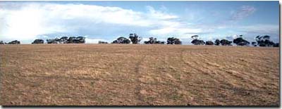 LS12 Landscape | 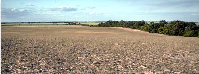 LS12 Landscape - another view. |
Soil Profile Morphology:
Surface Soil
| A1 | 0-10 cm | Greyish brown (10YR5/2); loamy sand; structureless; loose consistence dry; pH 6.7: | 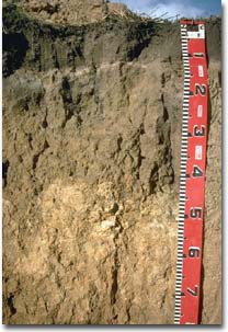 LS12 Profile |
| A2 | 10-11 cm | Conspicuously bleached; sand: | |
| Subsoil | |||
| B21 | 11-30 cm | Light yellowish brown (10YR6/4) with reddish yellow (7.5YR6/8) mottles; sandy clay; strong coarse columnar structure with cemented bleached domed capping; very strong consistence dry; pH 8.5: | |
| B22 | 30-40 cm | Light yellowish brown (10YR6/4) with reddish brown (7.5YR6/8) mottles; medium clay (sandy); moderate medium prismatic, breaking to moderate medium blocky structure; strong consistence dry; pH 9.1: | |
| B23 | 40-65 cm | Very pale brown (10YR7/4) with strong brown (7.5YR5/8) mottles; medium clay; structure similar to above; contains many (20 - 50%) soft and hard calcareous segregations; pH 9.4: | |
| B24 | 65+ cm | Strong brown (7.5YR5/6); medium heavy clay; structure similar to above; pH 9.4; weathered sandstone begins at 170 cm. | |
Note: Weathered sandstone occurs at 170 cm depth. | |||
Key Profile Features:
- Strongly texture contrast between sandy surface horizons and clay subsoil.
- Coarse columnar structure with cemented capping at top of subsoil.
| - | pH | Salinity | ||
Surface (A1 horizon) | Slightly Acid | Very Low | Non-Sodic | None |
Subsoil (B21 horizon) | Moderately Alkaline | Low | Strongly Sodic | Strong |
Deeper Subsoil (at 85 cm) | Very Strongly Alkaline | Medium | Strongly Sodic | Strong |
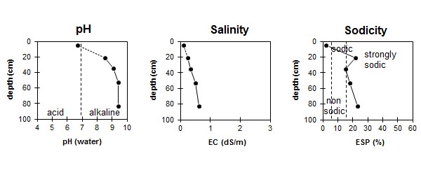
| The surface soil is slightly acid. The subsoil is moderately alkaline becoming very strongly alkaline at depth. | The salinity rating is very low in the surface. The subsoil is low becoming moderate with depth. | The surface is non-sodic. The subsoil is strongly sodic. |
Chemical and Physical Analysis:
Horizon | Horizon Depth (cm) | pH (water) | pH (CaCl2) | EC dS/m | Sodium Chloride % | Exchangeable Cations | |||
Ca | Mg | K | Na | ||||||
meq/100g | |||||||||
A1 | 0-10 | 6.7 | 6.1 | 0.1 | 1.9 | 0.5 | 0.3 | <0.1 | |
A2 | 10-11 | - | - | - | - | - | - | - | - |
B21 | 11-30 | 8.5 | 7.4 | 0.24 | 3.8 | 6.7 | 0.6 | 3 | |
B22 | 30-40 | 9.1 | 8.2 | 0.33 | <0.05 | 9.1 | 11.1 | 1.3 | 3.8 |
B23 | 40-65 | 9.4 | 8.4 | 0.5 | 0.05 | 6.7 | 9.5 | 1 | 3.8 |
B24 | 65-100 | 9.4 | 8.5 | 0.61 | 4.9 | 10.8 | 1.1 | 4.8 | |
Horizon | Horizon Depth (cm) | Total Nitrogen % | Oxidisable Organic Carbon % | Field Capacity pF2.5 | Wilting Point pF4.2 | Coarse Sand (0.2-2.0 mm) % | Fine Sand (0.02-0.2 mm) % | Silt (0.002-0.02 mm) % | Clay (<0.002 mm) % |
A1 | 0-10 | <0.05 | 0.8 | 4.3 | 2.4 | ||||
A2 | 10-11 | - | - | - | - | - | - | - | - |
B21 | 11-30 | 24.5 | 10.5 | 38 | 33 | 2 | 26 | ||
B22 | 30-40 | 33.8 | 23.1 | ||||||
B23 | 40-65 | ||||||||
B24 | 65-100 |
Surface (A) Horizons
- The light textured shallow surface horizon is potentially wind erodible and if removed would expose the strongly sodic and dispersive subsoil to water erosion.
- Plant available water capacity is limited by the shallow and sandy textured surface horizons. The low wilting point value (ie. 2%), however, means that plants will be able to utilise light rain falling on relatively dry soil. Plants will soon suffer moisture stress if further rains do not fall.
- The surface horizons have a very low inherent fertility (based on the sum of the basic exchangeable cations) and relatively low levels of organic carbon and nitrogen. Increasing organic mater levels on light textured soils will improve the nutrient holding capacity.
- The strongly sodic and dispersive subsoil is likely to result in restricted water and root movement down the profile. The hard capping of the columnar structured B horizon is also likely to restrict root penetration. The conspicuously bleached A2 horizon above the sodic B horizon indicates that periodic waterlogging occurs.
- Much of the subsoil is very strongly alkaline which indicates that some nutrients (eg. iron, manganese, copper and zinc) may be poorly available to plants. Plant tissue analysis can be used to assess deficiencies.
- The high levels of exchangeable sodium in the subsoil may also result in nutrient imbalances and may even have a toxic effect on some plants.
Comments from Landholder:
- Waterlogging occurs.
- Boron toxicity problem may occur at depth associated with carbonate layer.
- Lucerne roots have difficulty penetrating subsoil.
Profile Described By: Mark Imhof, David Rees, Sonia Thompson (October 1994).
© State of Victoria (Agriculture Victoria) 1996 - .

This work, Victorian Resources Online, is licensed under a Creative Commons Attribution 4.0 licence. You are free to re-use the work under that licence, on the condition that you credit the State of Victoria (Agriculture Victoria) as author, indicate if changes were made and comply with the other licence terms.
The licence does not apply to ‘branding’ or some ‘images or photographs’ that may be owned by third parties. We ask you to seek prior approval to use images using the VRO feedback form. Access to higher quality images can also be provided on request.
This page was last updated on .