
IS3
Location: Coromby
Australian Soil Classification: Calcic, Subnatric, Red SODOSOL
Northcote Factual Key: Dr2.33
Great Soil Group: red-brown earth
Soil Type: Drung Sandy clay Loam
General Description: Eroded crest within a plain.
Geology: Quaternary Woorinen Formation: aeolian dune sand, calcareous clay
Soil Profile Morphology:
Surface Soil
| A1 | 0-5 cm | Brown (7.5YR4/4); sandy clay loam; hardsetting surface condition; weak coarse friable granular structure; pH 7.1; sharp and wavy boundary to: | 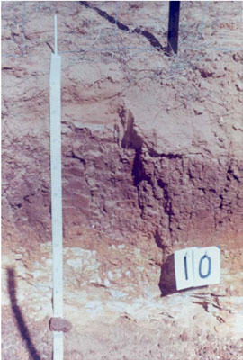 IS3 Profile |
| A2j | 5–15 cm | Brown (7.5YR4/4) sporadically bleached (10YR7/2d); sandy clay loam; weak coarse friable granular structure; pH 6.2; sharp and wavy boundary to: | |
| Subsoil | |||
| B21 | 15–45 cm | Reddish brown (5YR4/4); light clay; plastic; moderate very coarse prismatic structure; strong consistence dry; slightly sticky consistence wet; very few (<2%) hard carbonate segregations; pH 7.7; clear and smooth boundary to: | |
| B22 | 45–65 cm | Yellowish brown (10YR5/8); medium clay; plastic; moderate coarse subangular blocky structure; strong consistence dry; sticky consistence wet; very few (<2%) hard carbonate segregations; pH 8.9; sharp and broken boundary to: | |
| B23 | 65–75 cm | Yellowish brown (10YR5/8); medium clay; plastic; very large lenticular structure (slickensides); strong consistence dry; sticky consistence wet; few (2-10%) soft carbonate segregations; rock fragments; pH 9.0: | |
| C | 75+ cm | Impenetrable rock. | |
Chemical and Physical Analysis:
Horizon | Sample Depth cm | pH | EC dS/m | Sodium Chloride % | Bulk Density | Exchangeable Calcium cmol-/kg | Exchangeable Magnesium cmol-/kg | Exchangeable Potassium cmol-/kg | Exchangeable Sodium cmol-/kg | Total Nitrogen % | Organic Carbon % | Exchangeable Acidity cmol-/kg | Field Capacity -30okPa | Permanent Wilting Point -1500okPa | Coarse Sand % | Fine Sand % | Silt % | Clay % | |
H2O | CaCl2 | ||||||||||||||||||
A1 | 0–5 | 7.1 | 6.4 | 0.06 | 0.01 | 1.47 | 3.1 | 0.4 | 0.6 | 0.08 | 1.01 | 2.9 | 4.7 | 45 | 23 | 13 | 14 | ||
A2j | 5–15 | 6.2 | 0.07 | 0.01 | 1.54 | 2.4 | 0.8 | 0.4 | 0.1 | 0.04 | 0.54 | 3.3 | 13.1 | 4.8 | 43 | 24 | 15 | 16 | |
B21 | 15–45 | 7.7 | 6.7 | 0.3 | 0.02 | 1.22 | 11.8 | 12 | 2.5 | 3.3 | 0.09 | 0.58 | 7.1 | 30 | 10 | 6 | 3 | 79 | |
B22 | 45–65 | 8.9 | 0.46 | 0.02 | 10.5 | 12.4 | 2.2 | 3.3 | 0.05 | 0.27 | 1.5 | 24 | 20 | 12 | 6 | 62 | |||
B23 | 65–75 | 9.0 | 0.33 | 0.02 | 6.8 | 9 | 1.6 | 2.6 | 0.03 | 0.17 | 1.0 | 15.9 | 32 | 15 | 8 | 44 | |||
Management Considerations:
- Strong texture contrasts (16% to 79% clay).
- Neutral upper soil becoming alkaline at depth, high level of nutrients in upper subsoil (B21, B22 horizons).
- Thin surface and subsurface horizon with, poor structure and high coarse sand component.
- Subsurface soil is leached with fewer nutrients than above or below.
- Subsoil is sodic, with sodicity and salinity higher in upper and mid subsoil (B21 and B22 horizons).
- Subsoil is reddish in upper subsoil, indicating relatively free drainage and air movement (oxidising conditions), despite clay percentage.
- Moderate site drainage.
Profile Described By: John Martin, Nabil Badawy, Ron Cawood, Geoff Pope, John Galea, John Turner (1970).
© State of Victoria (Agriculture Victoria) 1996 - .

This work, Victorian Resources Online, is licensed under a Creative Commons Attribution 4.0 licence. You are free to re-use the work under that licence, on the condition that you credit the State of Victoria (Agriculture Victoria) as author, indicate if changes were made and comply with the other licence terms.
The licence does not apply to ‘branding’ or some ‘images or photographs’ that may be owned by third parties. We ask you to seek prior approval to use images using the VRO feedback form. Access to higher quality images can also be provided on request.
This page was last updated on .