
IS14
Location: Murtoa
Morphological Soil Type: Drung Sandy Clay Loam
Australian Soil Classification: Calcic, Subnatric, Red SODOSOL
Northcote Factual Key: Dr 2.33
Great Soil Group: red-brown earth
Mapping Unit: Drung Sandy Clay Loam
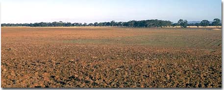
General Landscape Description: Crest of a slight rise in the prior stream flood plain landscape.
Site Description: Cleared and cultivated area.
Geology: Late Tertiary to Quaternary Shepparton Formation.
Native Vegetation: Probably originally Buloke (Casuarina luehmannii) vegetation.
 IS14 Landscape |
Soil Profile Morphology:
Surface soil
| A1 | 0-5 cm | Dark brown (7.5YR3/4); fine sandy clay loam; plastic; hardsetting surface condition; weak coarse angular blocky structure; strong consistence dry, moderately sticky consistence wet; pH 7.8; sharp and wavy change to: | 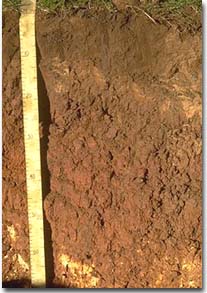 IS14 Profile |
| A2 | 5-10 cm | Brown (7.5YR4/3) sporadically bleached (10YR7/1); fine sandy clay loam; weak coarse blocky structure; pH 8.1; sharp and wavy change to: | |
| Subsoil | |||
| B21 | 10-25 cm | Reddish brown (5YR4/4); light clay; plastic; moderate coarse prismatic structure; strong consistence dry, moderately sticky consistence wet; pH 8.7; sharp and wavy change to: | |
| B22 | 25-45 cm | Yellowish red (5YR4/6); light clay; plastic; moderate coarse prismatic structure; strong consistence dry, moderately sticky consistence wet; pH 9.3; clear and wavy change to: | |
| B231k | 45-90 cm | Strong brown (7.5YR5/6) with faint yellowish red (5YR4/6) fine mottles; medium clay; plastic; weak blocky structure; strong consistence dry, moderately sticky consistence wet; contains very few (< 2 %) hard carbonates and a few (2-10%) soft carbonates; pH 9.3: | |
| B232k | 90-130+ cm | Strong brown (7.5YR5/6) with faint yellowish red (5YR4/6) fine mottles; medium clay; plastic; weak blocky structure; strong consistence dry, moderately sticky consistence wet; contains very few (< 2 %) hard carbonates and a few (2-10%) soft carbonates; pH 9.3. |
Key Profile Features:
- Strong texture contrast between surface (A) horizons (< 24% clay) and subsoil (B21) horizon (56% clay).
Soil Profile Characteristics:
pH | Salinity Rating | |||
Surface (A1 horizon) | Slightly Alkaline | Low | Non-Sodic | None1 |
Subsoil (B21 horizon) | Strongly Alkaline | Low | Sodic | Slight |
Deeper Subsoil (at 1 m) | Very Strongly Alkaline | High | Very Strongly Sodic | None2 |
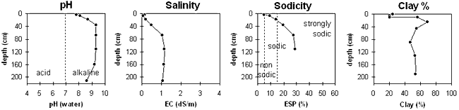
| The surface soil is slightly alkaline. The upper subsoil is strongly alkaline becoming very strongly alkaline with depth. | The salinity rating is low in the surface and upper subsoil becoming high with depth. | The surface is non-sodic. The upper subsoil is sodic becoming very strongly sodic with depth. | The clay content jumps markedly at the surface subsoil boundary. |
Horizon | Sample Depth cm | pH H2O | EC dS/m | Sodium Chloride % | Exchangeable Calcium cmol-/kg | Exchangeable Magnesium cmol-/kg | Exchangeable Potassium cmol-/kg | Exchangeable Sodium cmol-/kg | Total Nitrogen % | Organic Carbon % | Bulk Density | Exchangeable Acidity cmol-/kg | Field Capacity -30okPa | Permanent Wilting Point -1500okPa | Coarse Sand % | Fine Sand % | Silt % | Clay % |
A1 | 0–5 | 7.8 | 0.11 | 0.01 | 7 | 3.8 | 0.7 | 0.6 | 0.09 | 1.22 | 1.28 | 2.7 | 19.6 | 8.4 | 20 | 45 | 8 | 24 |
A2 | 5–10 | 8.1 | 0.07 | 0.01 | 4.7 | 3.4 | 0.4 | 0.9 | 0.06 | 0.75 | 2 | 6.7 | 22 | 48 | 9 | 20 | ||
B21 | 10–25 | 8.7 | 0.18 | 0.03 | 10 | 12.5 | 1.6 | 3.9 | 0.08 | 0.68 | 1.26 | 1.3 | 23.3 | 12 | 24 | 5 | 56 | |
B22 | 25–45 | 9.3 | 0.48 | 0.06 | 9.4 | 17.1 | 1.6 | 6.8 | 0.06 | 0.47 | 1.28 | 26.7 | 6 | 17 | 4 | 69 | ||
B31k | 45–90 | 9.3 | 1.03 | 0.13 | 6 | 13.3 | 1.5 | 8 | 0.03 | 0.25 | 1.45 | 23.3 | 9 | 20 | 5 | 55 | ||
B32k | 90–130 | 9.3 | 1.17 | 0.18 | 5.2 | 12.6 | 1.4 | 7.8 | 0.02 | 0.13 | 20.1 | 13 | 22 | 7 | 47 | |||
B233 | 130–190 | 9.2 | 1.11 | 0.16 | 20.3 | 12 | 22 | 9 | 53 | |||||||||
B234 | 190–230 | 8.6 | 1.05 | 0.17 | 21.1 | 11 | 26 | 7 | 54 |
Management Considerations:
Whole Profile
- Plant available water capacity (PAWC) is considered to be relatively low (estimated at 79 mm). This is based on available laboratory data and assumes an effective rooting depth of 45 cm. Effective rooting depth will be restricted by the strongly sodic deeper subsoil which has a high level of soluble salts.
Surface (A) Horizons
- The surface soil disperses moderately after remoulding. This indicates that cultivation or overstocking of the soil when in a wet condition may result in dispersion and consequent structural degradation (eg. exacerbated hardsetting, surface sealing, cloddiness) occurring.
- The surface soil has a high fine sand content (ie. 45%) and is hardsetting when dry. Soils such as these rely to a large extent on organic matter for maintaining aggregation. Organic matter will build up under pasture but will decline if cultivation takes place. Practices such as residue retention, minimum tillage and including pasture rotations could be utilised if cropping takes place in order to build up organic matter.
- The subsurface (A2) horizon is sodic and is likely to disperse significantly after remoulding. This indicates that if tillage occurs when this horizon is in a wet condition, a plough pan may develop. Gypsum application on such soils may assist in improving soil structural condition.
Subsoil (B) Horizons
- The coarsely structured subsoil becomes strongly sodic from 25 cm depth, and has a low exchangeable calcium to magnesium ratio (ie. < 0.6). This is likely to result in restricted root and water movement in the subsoil. The presence of a conspicuous bleach in the A2 horizon indicates that water movement into the subsoil is being restricted.
- The high level of exchangeable sodium and magnesium in the subsoil may also result in nutrient imbalances and may even have a toxic effect on some plants.
- The strongly alkaline subsoil indicates that some nutrients (eg. manganese, iron, copper, zinc) may be poorly available to plants.
- The level of soluble salts becomes high from 45 cm depth. This is likely to restrict the growth of salt sensitive species (eg. faba beans, chickpeas, lupins).
Profile Described By: John Martin, Nabil Badawy, Ron Cawood, Geoff Pope, John Galea, John Turner (1970).
Reference: "Major Agricultural Soils of the Wimmera Irrigation Area". John Martin, Mark Imhof, Lourey Ruth, Rob Nink, Karen DePlater, Paul Rampant, Sonia Thompson, S. Alexander. Department of Natural Resources and Environment, Victoria. 1996.
© State of Victoria (Agriculture Victoria) 1996 - .

This work, Victorian Resources Online, is licensed under a Creative Commons Attribution 4.0 licence. You are free to re-use the work under that licence, on the condition that you credit the State of Victoria (Agriculture Victoria) as author, indicate if changes were made and comply with the other licence terms.
The licence does not apply to ‘branding’ or some ‘images or photographs’ that may be owned by third parties. We ask you to seek prior approval to use images using the VRO feedback form. Access to higher quality images can also be provided on request.
This page was last updated on .