
IS12
Location: Longerenong.
Australian Soil Classification: Endocalcareous-Endohypersodic, Epipedal, Grey VERTOSOL
Northcote Factual Key: Ug5.29
Great Soil Group: grey clay
Soil Type: Murtoa Clay
General Landscape Description: Anastomotic plain.
Geology: Quaternary Shepparton Formation: fluvial silt, sand and minor gravel.
Soil Profile Morphology:
Surface Soil
| A1 | 0-5 cm | Dark grey (10YR4/1); light clay; subplastic; cracking and self-mulching surface condition; moderate coarse subangular blocky structure; very strong consistence dry; slightly sticky consistence wet; pH 7.2; sharp and wavy boundary to: | 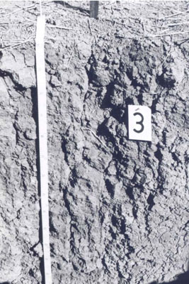 IS12 Profile. |
| Subsoil | |||
| B21 | 5-25 cm | Grey (5Y5/1); light clay; subplastic; moderate coarse prismatic structure; strong consistence dry; moderately sticky consistence wet; pH 8.9. | |
| B22 | 25-60 cm | Grey (5Y5/1); heavy clay; subplastic; moderate coarse prismatic structure; strong consistence dry; moderately sticky consistence wet; very few (<2%) hard and soft carbonate segregations; pH 9.2; sharp and wavy boundary to: | |
| B23 | 60-110 cm | Grey (5Y5/1); heavy clay; plastic; coarse lenticular structure (slickensides); strong consistence dry; moderately sticky consistence wet; very few (<2%) hard carbonate segregations; pH 9.3; gradual boundary to: | |
| B31 | 110-150 cm | Greyish brown (10Y5/2); heavy clay; plastic; coarse lenticular structure (slickensides); strong consistence dry; slightly sticky consistence wet; very few (<2%) hard carbonate segregations; pH 9.3; gradual boundary to: | |
| B32 | 150-180 | Brown (10Y5/3); heavy clay; plastic; coarse lenticular structure (slickensides); strong consistence dry; slightly sticky consistence wet; pH 9.1; gradual boundary to: | |
| B33 | 180-215 | Greyish brown (10Y5/2); heavy clay; plastic; coarse lenticular structure (slickensides); strong consistence dry; slightly sticky consistence wet; pH 8.9. | |
Chemical and Physical Analysis:
Horizon | Sample Depth cm | pH H2O | EC dS/m | Sodium Chloride % | Exchangeable Calcium cmol-/kg | Exchangeable Magnesium cmol-/kg | Exchangeable Potassium cmol-/kg | Exchangeable Sodium cmol-/kg | Organic Carbon % | Total Nitrogen % | Exchangeable Acidity cmol-/kg | Field Capacity -30okPa | Permanent Wilting Point -1500okPa | Coarse Sand % | Fine Sand % | Silt % | Clay % |
A1 | 0–5 | 7.2 | 0.11 | 0.02 | 9.9 | 8.7 | 2.5 | 0.7 | 1.13 | 0.11 | 6.7 | 34.2 | 18.4 | 7 | 23 | 8 | 59 |
B21 | 5–25 | 8.9 | 0.14 | 0.02 | 16.6 | 14.2 | 2 | 3.1 | 0.32 | 0.05 | 3 | 42.3 | 25.7 | 3 | 7 | 6 | 83 |
B22 | 25–60 | 9.2 | 0.24 | 0.02 | 13.4 | 17.3 | 2.1 | 5.6 | 0.26 | 0.03 | 21.9 | 3 | 9 | 6 | 81 | ||
B23 | 60–110 | 9.3 | 0.41 | 0.05 | 9.7 | 17 | 1.9 | 8.7 | 0.22 | 0.02 | 26.7 | 4 | 11 | 8 | 76 | ||
B31 | 110–150 | 9.3 | 0.64 | 0.11 | 6.6 | 14.5 | 1.7 | 10.4 | 0.11 | 0.02 | 24.2 | 5 | 14 | 9 | 69 | ||
B32 | 150–180 | 9.1 | 0.62 | 0.12 | 25.2 | 4 | 15 | 10 | 70 | ||||||||
B33 | 180–215 | 8.9 | 0.67 | 0.11 | 24.8 | 4 | 15 | 10 | 69 |
Management Considerations:
- Cracking clay profile, very high clay percentage, decreasing below upper subsoil
- Neutral thin surface soil and alkaline below
- Friable self mulching surface, feels lighter than lab data suggests (subplastic), as does upper subsoil
- Calcium percentage decreasing with depth
- Yellow hue profile(5Y) and lighter coloured deep subsoil, poorer internal drainage
- Subsoil is strongly sodic and salinity increases at depth, particularly below 50cm
- Cracking may allow air and seasonal moisture to penetrate
- Very strong consistence when dry, implications for compaction and implement use
- Landform element, plain: poor site drainage
© State of Victoria (Agriculture Victoria) 1996 - .

This work, Victorian Resources Online, is licensed under a Creative Commons Attribution 4.0 licence. You are free to re-use the work under that licence, on the condition that you credit the State of Victoria (Agriculture Victoria) as author, indicate if changes were made and comply with the other licence terms.
The licence does not apply to ‘branding’ or some ‘images or photographs’ that may be owned by third parties. We ask you to seek prior approval to use images using the VRO feedback form. Access to higher quality images can also be provided on request.
This page was last updated on .